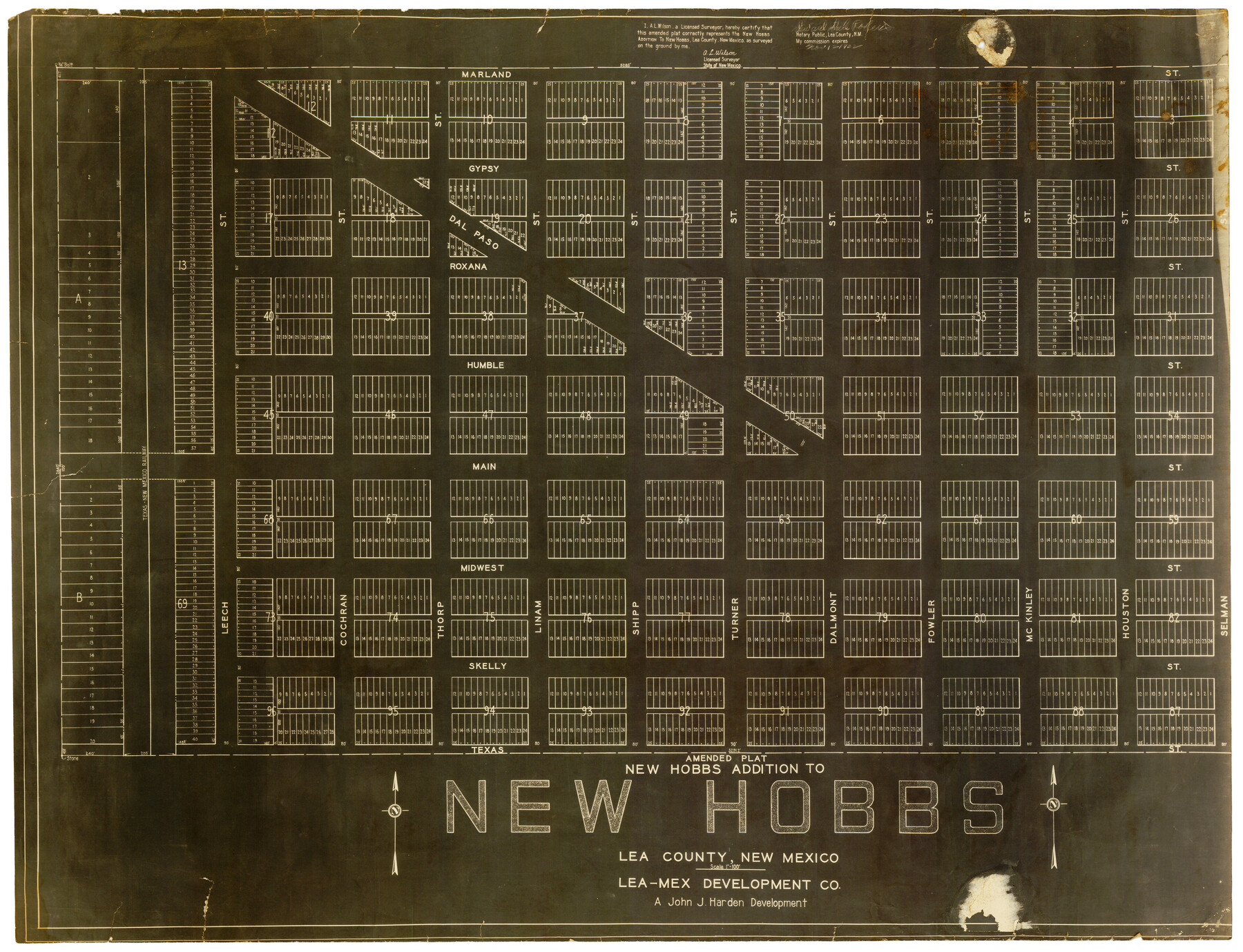
Amended Plat New Hobbs Addition to New Hobbs, Lea County, New Mexico
-
Map/Doc
92418
-
Collection
Twichell Survey Records
-
People and Organizations
A.L. Wilson (Surveyor/Engineer)
-
Counties
Lea [New Mexico]
-
Height x Width
24.1 x 18.5 inches
61.2 x 47.0 cm
Part of: Twichell Survey Records
[Blocks T1, T2, and T3]
![90995, [Blocks T1, T2, and T3], Twichell Survey Records](https://historictexasmaps.com/wmedia_w700/maps/90995-1.tif.jpg)
Print $20.00
- Digital $50.00
[Blocks T1, T2, and T3]
1888
Size 16.0 x 25.9 inches
Map/Doc 90995
[Sketch showing I. & G. N. Block 8]
![91703, [Sketch showing I. & G. N. Block 8], Twichell Survey Records](https://historictexasmaps.com/wmedia_w700/maps/91703-1.tif.jpg)
Print $2.00
- Digital $50.00
[Sketch showing I. & G. N. Block 8]
1919
Size 5.0 x 8.7 inches
Map/Doc 91703
Plat in Pecos County, Texas

Print $20.00
- Digital $50.00
Plat in Pecos County, Texas
Size 33.2 x 23.1 inches
Map/Doc 91601
[Double Lakes Area Northwest of Tohoka, Block 3, Surveys 319, 321, and 322]
![91298, [Double Lakes Area Northwest of Tohoka, Block 3, Surveys 319, 321, and 322], Twichell Survey Records](https://historictexasmaps.com/wmedia_w700/maps/91298-1.tif.jpg)
Print $20.00
- Digital $50.00
[Double Lakes Area Northwest of Tohoka, Block 3, Surveys 319, 321, and 322]
Size 21.1 x 20.1 inches
Map/Doc 91298
L. A. Wells Subdivision of Sections 6-11-12-13-18, Block V, Cochran County, Tex.

Print $2.00
- Digital $50.00
L. A. Wells Subdivision of Sections 6-11-12-13-18, Block V, Cochran County, Tex.
Size 6.7 x 8.4 inches
Map/Doc 90441
![92619, [Hart Townsite], Twichell Survey Records](https://historictexasmaps.com/wmedia_w700/maps/92619-1.tif.jpg)
Rhyne Simpson Addition No. 2, City of Lubbock Section 3, Block O

Print $20.00
- Digital $50.00
Rhyne Simpson Addition No. 2, City of Lubbock Section 3, Block O
1951
Size 12.2 x 18.4 inches
Map/Doc 92731
Sketch of Surveys in Crosby & Garza Cos.

Print $20.00
- Digital $50.00
Sketch of Surveys in Crosby & Garza Cos.
Size 18.0 x 23.8 inches
Map/Doc 90347
[Texas Boundary Line]
![92075, [Texas Boundary Line], Twichell Survey Records](https://historictexasmaps.com/wmedia_w700/maps/92075-1.tif.jpg)
Print $20.00
- Digital $50.00
[Texas Boundary Line]
Size 21.4 x 11.9 inches
Map/Doc 92075
Ed F. Mann and Ed Liedtke's Subdivision of Leagues 22 and 23 McCulloch County School Land Hockley County, Texas

Print $20.00
- Digital $50.00
Ed F. Mann and Ed Liedtke's Subdivision of Leagues 22 and 23 McCulloch County School Land Hockley County, Texas
Size 25.9 x 22.0 inches
Map/Doc 92212
[M. B. & B. Blocks A, B and C and various County School Land Leagues]
![90282, [M. B. & B. Blocks A, B and C and various County School Land Leagues], Twichell Survey Records](https://historictexasmaps.com/wmedia_w700/maps/90282-1.tif.jpg)
Print $20.00
- Digital $50.00
[M. B. & B. Blocks A, B and C and various County School Land Leagues]
Size 15.8 x 19.0 inches
Map/Doc 90282
Sketch Showing D. Rubin Surveys

Print $20.00
- Digital $50.00
Sketch Showing D. Rubin Surveys
1926
Size 35.1 x 24.5 inches
Map/Doc 91165
You may also like
General Highway Map, McMullen County, Texas

Print $20.00
General Highway Map, McMullen County, Texas
1961
Size 24.7 x 18.3 inches
Map/Doc 79592
Harris County Boundary File 3

Print $16.00
- Digital $50.00
Harris County Boundary File 3
Size 14.7 x 7.0 inches
Map/Doc 54298
Cameron County Boundary File 1

Print $14.00
- Digital $50.00
Cameron County Boundary File 1
Size 14.1 x 8.6 inches
Map/Doc 51087
Martin County Sketch File 1

Print $66.00
- Digital $50.00
Martin County Sketch File 1
Size 19.3 x 8.9 inches
Map/Doc 30626
Rockwall County Boundary File 4

Print $6.00
- Digital $50.00
Rockwall County Boundary File 4
Size 10.9 x 8.4 inches
Map/Doc 58396

Detail Sketch of A.B. Robertson's Ranch and J.W. James' Ranch situated in Garza and Crosby Counties, Texas

Print $40.00
- Digital $50.00
Detail Sketch of A.B. Robertson's Ranch and J.W. James' Ranch situated in Garza and Crosby Counties, Texas
Size 51.8 x 34.1 inches
Map/Doc 93030
Henderson County Working Sketch 37

Print $20.00
- Digital $50.00
Henderson County Working Sketch 37
1982
Size 29.4 x 22.0 inches
Map/Doc 66170
Edwards County Sketch File 49

Print $20.00
- Digital $50.00
Edwards County Sketch File 49
1958
Size 25.6 x 27.9 inches
Map/Doc 11444
Donley County Sketch File 28

Print $40.00
- Digital $50.00
Donley County Sketch File 28
Size 25.7 x 9.1 inches
Map/Doc 21266
Karnes County Sketch File 17

Print $4.00
- Digital $50.00
Karnes County Sketch File 17
1873
Size 12.8 x 8.0 inches
Map/Doc 28622
Polk County Sketch File 29a

Print $4.00
- Digital $50.00
Polk County Sketch File 29a
Size 12.1 x 8.2 inches
Map/Doc 34202