Cameron County Boundary File 1
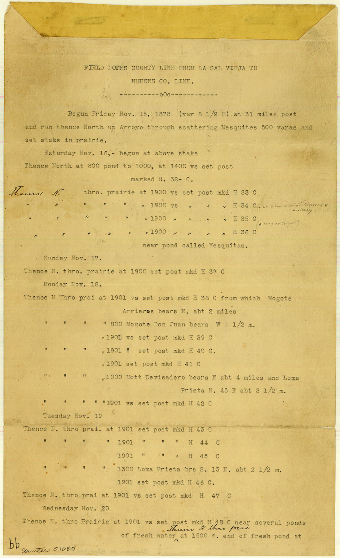
[Certified copy of field notes of Cameron & Hidalgo County Line as run by J. J. Cocke]
-
Map/Doc
51087
-
Collection
General Map Collection
-
Counties
Cameron
-
Subjects
County Boundaries
-
Height x Width
14.1 x 8.6 inches
35.8 x 21.8 cm
Part of: General Map Collection
Tarrant County Rolled Sketch 3

Print $20.00
- Digital $50.00
Tarrant County Rolled Sketch 3
Size 23.3 x 28.6 inches
Map/Doc 7910
Edwards County Rolled Sketch 27

Print $20.00
- Digital $50.00
Edwards County Rolled Sketch 27
1959
Size 18.0 x 33.2 inches
Map/Doc 5813
Dickens County Rolled Sketch 13

Print $40.00
- Digital $50.00
Dickens County Rolled Sketch 13
1950
Size 43.4 x 53.7 inches
Map/Doc 45135
Limestone County Sketch File 15

Print $8.00
- Digital $50.00
Limestone County Sketch File 15
1883
Size 12.7 x 8.0 inches
Map/Doc 30181
Bell County Sketch File 29

Print $4.00
- Digital $50.00
Bell County Sketch File 29
1874
Size 13.1 x 8.1 inches
Map/Doc 14439
Reeves County Working Sketch 2

Print $20.00
- Digital $50.00
Reeves County Working Sketch 2
1903
Size 22.6 x 42.4 inches
Map/Doc 63444
San Patricio County Rolled Sketch 31

Print $20.00
- Digital $50.00
San Patricio County Rolled Sketch 31
1941
Size 43.1 x 42.6 inches
Map/Doc 9898
Briscoe County Sketch File H-1

Print $40.00
- Digital $50.00
Briscoe County Sketch File H-1
Size 21.7 x 18.2 inches
Map/Doc 11006
Sherman County

Print $20.00
- Digital $50.00
Sherman County
1932
Size 39.6 x 36.4 inches
Map/Doc 77422
Tom Green County Sketch File 87

Print $5.00
- Digital $50.00
Tom Green County Sketch File 87
1951
Size 8.7 x 11.2 inches
Map/Doc 38264
Orange County, West Half of Sabine River Showing Leases 5 and 6

Print $20.00
- Digital $50.00
Orange County, West Half of Sabine River Showing Leases 5 and 6
1957
Size 30.6 x 34.3 inches
Map/Doc 1934
Brewster County Sketch File 46

Print $16.00
- Digital $50.00
Brewster County Sketch File 46
1939
Size 9.3 x 6.2 inches
Map/Doc 16313
You may also like
Falls County Sketch File 6

Print $4.00
- Digital $50.00
Falls County Sketch File 6
1848
Size 12.8 x 8.3 inches
Map/Doc 22341
Bell County Working Sketch 9

Print $20.00
- Digital $50.00
Bell County Working Sketch 9
1954
Size 32.3 x 27.9 inches
Map/Doc 67349
Yoakum County Boundary File 1a

Print $20.00
- Digital $50.00
Yoakum County Boundary File 1a
Size 7.8 x 29.5 inches
Map/Doc 60196
Limestone County Working Sketch 26

Print $20.00
- Digital $50.00
Limestone County Working Sketch 26
1982
Size 39.6 x 44.1 inches
Map/Doc 70576
Caddo Lake and Subdivision

Print $20.00
- Digital $50.00
Caddo Lake and Subdivision
1918
Size 35.0 x 29.8 inches
Map/Doc 93283

The Republic County of Nacogdoches. November 28. 1839

Print $20.00
The Republic County of Nacogdoches. November 28. 1839
2020
Size 17.5 x 21.7 inches
Map/Doc 96245
Tarrant County Working Sketch 4

Print $20.00
- Digital $50.00
Tarrant County Working Sketch 4
1952
Size 20.6 x 19.7 inches
Map/Doc 62421
Texas, Aransas Bay, Copano Bay and St. Charles Bay

Print $40.00
- Digital $50.00
Texas, Aransas Bay, Copano Bay and St. Charles Bay
1934
Size 34.0 x 48.6 inches
Map/Doc 73434
Shelby County Working Sketch 3

Print $20.00
- Digital $50.00
Shelby County Working Sketch 3
1940
Size 28.9 x 19.4 inches
Map/Doc 63856
Bandera County Working Sketch 21

Print $20.00
- Digital $50.00
Bandera County Working Sketch 21
1948
Size 21.1 x 16.7 inches
Map/Doc 67617
Medina County Rolled Sketch 21

Print $20.00
- Digital $50.00
Medina County Rolled Sketch 21
2002
Size 33.5 x 19.1 inches
Map/Doc 76412