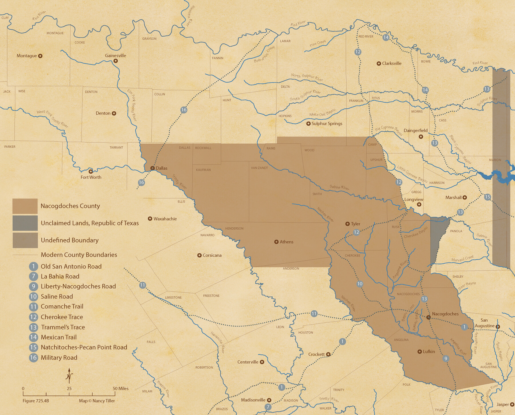
The Republic County of Nacogdoches. November 28. 1839
Figure No. 725.4 from 'A Boundary Atlas of Texas, 1821-1845' by Jim Tiller
-
Map/Doc
96245
-
Collection
Nancy and Jim Tiller Digital Collection
-
Object Dates
2020/1/1 (Creation Date)
-
People and Organizations
Jim Tiller (Author)
Nancy Tiller (Cartographer)
Gang Gong (GIS Professional)
-
Counties
Nacogdoches
-
Subjects
Atlas County Republic of Texas Texas Boundaries
-
Height x Width
17.5 x 21.7 inches
44.5 x 55.1 cm
-
Medium
digital image
-
Comments
To purchase a digital PDF copy of "A Boundary Atlas of Texas, 1821-1845" see 96437.
Part of: Nancy and Jim Tiller Digital Collection
From Citizens of Austin County Requesting to be Attached to Washington County, Undated

Print $20.00
From Citizens of Austin County Requesting to be Attached to Washington County, Undated
2020
Size 18.8 x 21.7 inches
Map/Doc 96398
Dominguez Empresario Colony. February 6, 1829

Print $20.00
Dominguez Empresario Colony. February 6, 1829
2020
Size 17.2 x 21.7 inches
Map/Doc 95992
The Republic County of Brazoria. Proposed, Late Fall 1837

Print $20.00
The Republic County of Brazoria. Proposed, Late Fall 1837
2020
Size 13.0 x 21.7 inches
Map/Doc 96109
Wilson Empresario Colony. May 27, 1826

Print $20.00
Wilson Empresario Colony. May 27, 1826
2020
Size 19.4 x 21.6 inches
Map/Doc 96010
The Chief Justice County of Gonzales. Lands in Conflict with Victoria County

Print $20.00
The Chief Justice County of Gonzales. Lands in Conflict with Victoria County
2020
Size 22.3 x 21.7 inches
Map/Doc 96048
The Republic County of Jefferson. January 20, 1841

Print $20.00
The Republic County of Jefferson. January 20, 1841
2020
Size 22.6 x 21.7 inches
Map/Doc 96198
Vehlein and Company Empresario Colony. December 21, 1826

Print $20.00
Vehlein and Company Empresario Colony. December 21, 1826
2020
Size 20.8 x 21.7 inches
Map/Doc 96007
The Republic County of Brazoria. January 20, 1841

Print $20.00
The Republic County of Brazoria. January 20, 1841
2020
Size 14.7 x 21.8 inches
Map/Doc 96114
The Republic County of Houston. December 29, 1845

Print $20.00
The Republic County of Houston. December 29, 1845
2020
Size 19.7 x 21.8 inches
Map/Doc 96183
The Republic County of Victoria. February 2, 1842

Print $20.00
The Republic County of Victoria. February 2, 1842
2020
Size 24.3 x 21.7 inches
Map/Doc 96299
The Republic County of Montgomery. Spring 1842

Print $20.00
The Republic County of Montgomery. Spring 1842
2020
Size 19.9 x 21.7 inches
Map/Doc 96240
The d’Orvane Colony. June 3, 1842

Print $20.00
The d’Orvane Colony. June 3, 1842
2020
Size 13.1 x 21.7 inches
Map/Doc 96369
You may also like
[Sketch showing parts of Blocks 3, 5, 22, M-20, S, T and Block BB, surveys 1, 2 and 3]
![91730, [Sketch showing parts of Blocks 3, 5, 22, M-20, S, T and Block BB, surveys 1, 2 and 3], Twichell Survey Records](https://historictexasmaps.com/wmedia_w700/maps/91730-1.tif.jpg)
Print $20.00
- Digital $50.00
[Sketch showing parts of Blocks 3, 5, 22, M-20, S, T and Block BB, surveys 1, 2 and 3]
Size 15.5 x 15.9 inches
Map/Doc 91730
Hill County Sketch File 21a

Print $4.00
- Digital $50.00
Hill County Sketch File 21a
1887
Size 10.8 x 8.4 inches
Map/Doc 26503
Andrews County Boundary File 1

Print $133.00
- Digital $50.00
Andrews County Boundary File 1
Size 14.6 x 9.0 inches
Map/Doc 49664
Flight Mission No. CRK-8P, Frame 107, Refugio County

Print $20.00
- Digital $50.00
Flight Mission No. CRK-8P, Frame 107, Refugio County
1956
Size 18.4 x 22.0 inches
Map/Doc 86968
Uvalde County Working Sketch 64, revised

Print $20.00
- Digital $50.00
Uvalde County Working Sketch 64, revised
1998
Size 34.2 x 35.5 inches
Map/Doc 72135
Johnson County

Print $20.00
- Digital $50.00
Johnson County
1943
Size 42.0 x 38.8 inches
Map/Doc 73199
Jack County Working Sketch 12

Print $20.00
- Digital $50.00
Jack County Working Sketch 12
1959
Size 18.0 x 22.4 inches
Map/Doc 66438
Kimble County Rolled Sketch 34

Print $20.00
- Digital $50.00
Kimble County Rolled Sketch 34
1976
Size 35.0 x 20.2 inches
Map/Doc 6524
Map of Grayson County

Print $20.00
- Digital $50.00
Map of Grayson County
1859
Size 22.6 x 19.5 inches
Map/Doc 3600
Shackelford County Working Sketch 2

Print $20.00
- Digital $50.00
Shackelford County Working Sketch 2
1914
Size 17.2 x 17.3 inches
Map/Doc 63842
Yoakum County Sketch File 14

Print $22.00
- Digital $50.00
Yoakum County Sketch File 14
1937
Size 14.5 x 14.6 inches
Map/Doc 40791
Reagan County Sketch File 8

Print $20.00
- Digital $50.00
Reagan County Sketch File 8
Size 25.6 x 47.6 inches
Map/Doc 10584