Limestone County Sketch File 15
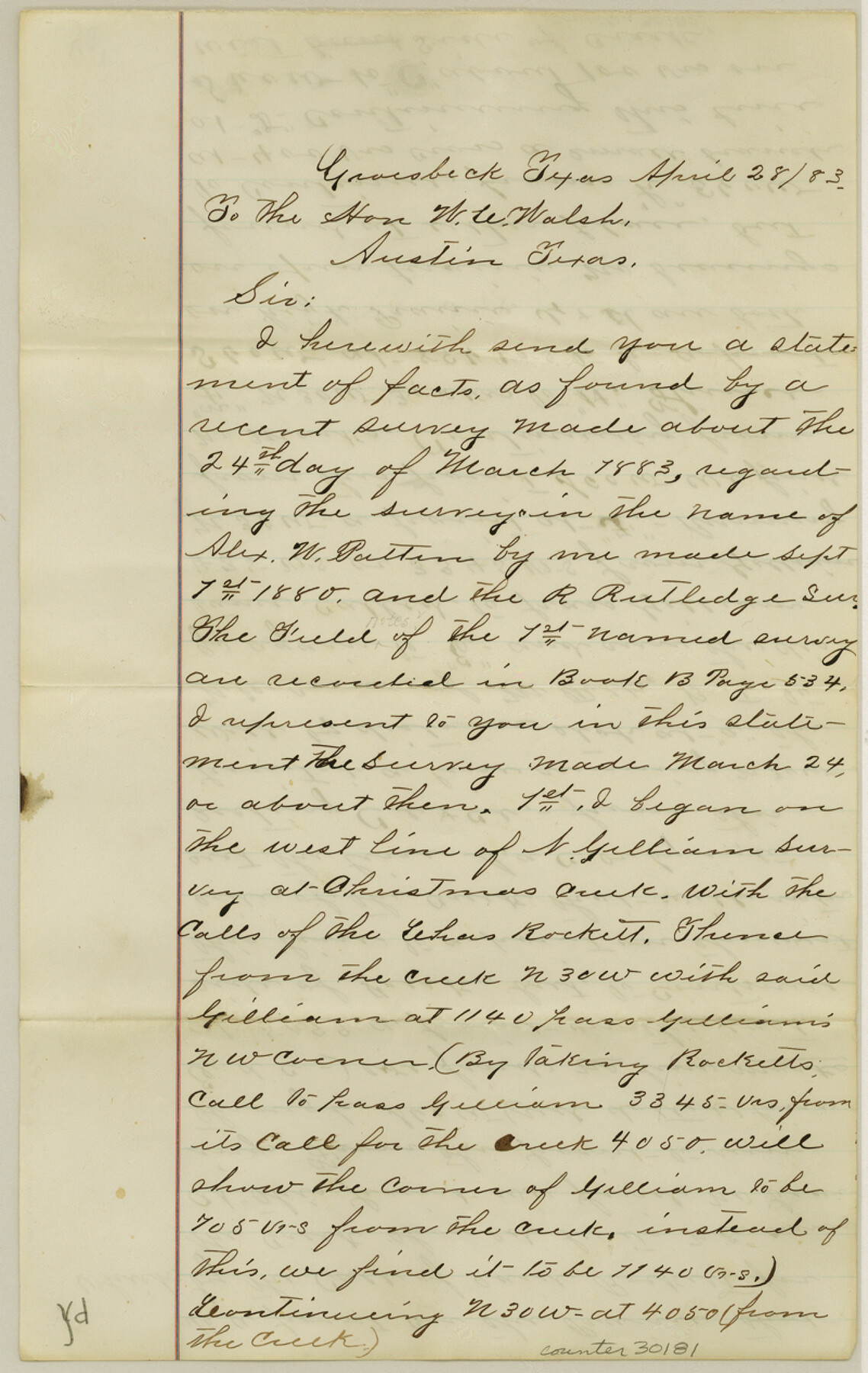
[Explanation regarding A. W. Patton survey]
-
Map/Doc
30181
-
Collection
General Map Collection
-
Object Dates
4/28/1883 (Creation Date)
5/2/1883 (File Date)
4/28/1883 (Correspondence Date)
3/24/1883 (Survey Date)
9/1/1880 (Survey Date)
-
People and Organizations
R.W. Priest (Surveyor/Engineer)
-
Counties
Limestone
-
Subjects
Surveying Sketch File
-
Height x Width
12.7 x 8.0 inches
32.3 x 20.3 cm
-
Medium
paper, manuscript
-
Features
Christmas Creek
Part of: General Map Collection
Presidio County Working Sketch Graphic Index, West Part, Sheet 1 (Sketches 1 to 74)

Print $20.00
- Digital $50.00
Presidio County Working Sketch Graphic Index, West Part, Sheet 1 (Sketches 1 to 74)
1974
Size 40.3 x 31.4 inches
Map/Doc 76672
Map of Starr County

Print $40.00
- Digital $50.00
Map of Starr County
1900
Size 51.6 x 25.8 inches
Map/Doc 4046
Wichita County Working Sketch 20

Print $20.00
- Digital $50.00
Wichita County Working Sketch 20
1950
Size 33.2 x 23.0 inches
Map/Doc 72530
Midland County Boundary File 1

Print $40.00
- Digital $50.00
Midland County Boundary File 1
Size 7.0 x 6.6 inches
Map/Doc 57140

Shackelford County Working Sketch 11

Print $20.00
- Digital $50.00
Shackelford County Working Sketch 11
1993
Size 16.2 x 37.8 inches
Map/Doc 63851

Flight Mission No. DQN-2K, Frame 191, Calhoun County

Print $20.00
- Digital $50.00
Flight Mission No. DQN-2K, Frame 191, Calhoun County
1953
Size 18.8 x 22.4 inches
Map/Doc 84332
Bexar County Sketch File 57

Print $4.00
- Digital $50.00
Bexar County Sketch File 57
1847
Size 10.4 x 8.3 inches
Map/Doc 14570
Garza County Sketch File 21

Print $4.00
- Digital $50.00
Garza County Sketch File 21
1906
Size 14.4 x 8.7 inches
Map/Doc 24078
Morris County Rolled Sketch 2A

Print $20.00
- Digital $50.00
Morris County Rolled Sketch 2A
Size 24.0 x 18.8 inches
Map/Doc 10254
Bee County Sketch File 29

Print $6.00
- Digital $50.00
Bee County Sketch File 29
1887
Size 14.0 x 8.8 inches
Map/Doc 14338
You may also like
Montgomery County Working Sketch 74

Print $20.00
- Digital $50.00
Montgomery County Working Sketch 74
1981
Size 37.6 x 45.6 inches
Map/Doc 71181
Lamb County Rolled Sketch 2

Print $20.00
- Digital $50.00
Lamb County Rolled Sketch 2
1917
Size 37.9 x 43.4 inches
Map/Doc 9412
The History of the Republic of Texas, from the discovery of the country to the present time; and the cause of her separation from the Republic of Mexico.

Print $1080.00
- Digital $50.00
The History of the Republic of Texas, from the discovery of the country to the present time; and the cause of her separation from the Republic of Mexico.
1842
Size 9.3 x 6.1 inches
Map/Doc 93866
Upton County Working Sketch 25

Print $20.00
- Digital $50.00
Upton County Working Sketch 25
1953
Size 38.2 x 31.2 inches
Map/Doc 69521
San Augustine County Working Sketch 27

Print $20.00
- Digital $50.00
San Augustine County Working Sketch 27
2009
Size 30.4 x 31.3 inches
Map/Doc 89020
Callahan County Rolled Sketch 4

Print $20.00
- Digital $50.00
Callahan County Rolled Sketch 4
1952
Size 20.8 x 30.6 inches
Map/Doc 5381
Terrell County Working Sketch 58

Print $40.00
- Digital $50.00
Terrell County Working Sketch 58
1960
Size 36.3 x 48.9 inches
Map/Doc 69579
Threading the Islands: Which track fits?

Threading the Islands: Which track fits?
1986
Size 20.5 x 14.7 inches
Map/Doc 96838
General Highway Map. Detail of Cities and Towns in Hale County, Texas [Plainview and vicinity]
![79109, General Highway Map. Detail of Cities and Towns in Hale County, Texas [Plainview and vicinity], Texas State Library and Archives](https://historictexasmaps.com/wmedia_w700/maps/79109.tif.jpg)
Print $20.00
General Highway Map. Detail of Cities and Towns in Hale County, Texas [Plainview and vicinity]
1940
Size 25.0 x 18.5 inches
Map/Doc 79109
Louisiana and Texas Intracoastal Waterway, Section 7, Galveston Bay to Brazos River and Section 8, Brazos River to Matagorda Bay

Print $20.00
- Digital $50.00
Louisiana and Texas Intracoastal Waterway, Section 7, Galveston Bay to Brazos River and Section 8, Brazos River to Matagorda Bay
1928
Size 30.7 x 42.9 inches
Map/Doc 61840
Copy of Surveyor's Field Book, Morris Browning - In Blocks 7, 5 & 4, I&GNRRCo., Hutchinson and Carson Counties, Texas

Print $2.00
- Digital $50.00
Copy of Surveyor's Field Book, Morris Browning - In Blocks 7, 5 & 4, I&GNRRCo., Hutchinson and Carson Counties, Texas
1888
Size 7.0 x 8.8 inches
Map/Doc 62272
Wood County Rolled Sketch 4

Print $20.00
- Digital $50.00
Wood County Rolled Sketch 4
1943
Size 37.0 x 29.2 inches
Map/Doc 8283