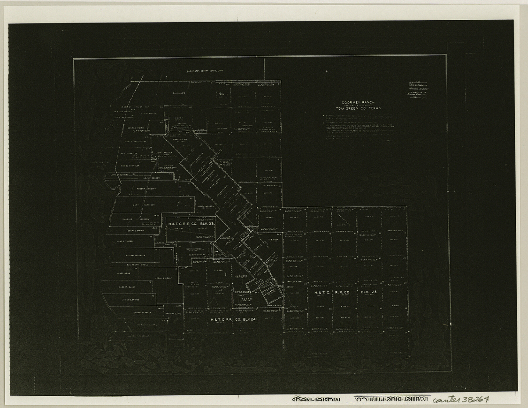
Tom Green County Sketch File 87
[Sketch of Door Key Ranch showing surveys in the vicinity of Pecan Creek and the South Fork of the Concho River southeast from San Angelo]
-
Map/Doc
38264
-
Collection
General Map Collection
-
Object Dates
1951 (Creation Date)
4/6/1988 (File Date)
-
People and Organizations
H.L. George (Surveyor/Engineer)
-
Counties
Tom Green
-
Subjects
Surveying Sketch File
-
Height x Width
8.7 x 11.2 inches
22.1 x 28.5 cm
-
Medium
photostat, negative
-
Features
Door Key Ranch
Part of: General Map Collection
Central America II. Including Texas, California and the Northern States of Mexico

Print $20.00
- Digital $50.00
Central America II. Including Texas, California and the Northern States of Mexico
1842
Size 14.1 x 16.7 inches
Map/Doc 93927
Flight Mission No. DAG-23K, Frame 14, Matagorda County

Print $20.00
- Digital $50.00
Flight Mission No. DAG-23K, Frame 14, Matagorda County
1953
Size 15.6 x 15.5 inches
Map/Doc 86476
San Augustine County Working Sketch 24

Print $20.00
- Digital $50.00
San Augustine County Working Sketch 24
1975
Size 27.8 x 39.1 inches
Map/Doc 63712
Bee County Sketch File 30

Print $6.00
- Digital $50.00
Bee County Sketch File 30
Size 14.2 x 8.9 inches
Map/Doc 14341
[Maps of surveys in Reeves & Culberson Cos]
![61139, [Maps of surveys in Reeves & Culberson Cos], General Map Collection](https://historictexasmaps.com/wmedia_w700/maps/61139.tif.jpg)
Print $20.00
- Digital $50.00
[Maps of surveys in Reeves & Culberson Cos]
1937
Size 30.7 x 24.7 inches
Map/Doc 61139
Maps & Lists Showing Prison Lands (Oil & Gas) Leased as of June 1955

Print $2.00
- Digital $50.00
Maps & Lists Showing Prison Lands (Oil & Gas) Leased as of June 1955
1955
Size 11.2 x 8.8 inches
Map/Doc 62863
Milam County Working Sketch 11

Print $20.00
- Digital $50.00
Milam County Working Sketch 11
1987
Size 43.8 x 31.9 inches
Map/Doc 71026
Harris County Working Sketch 119

Print $20.00
- Digital $50.00
Harris County Working Sketch 119
1984
Size 30.8 x 42.2 inches
Map/Doc 66011
[Surveys in the Bexar District along the Guadalupe River]
![124, [Surveys in the Bexar District along the Guadalupe River], General Map Collection](https://historictexasmaps.com/wmedia_w700/maps/124.tif.jpg)
Print $3.00
- Digital $50.00
[Surveys in the Bexar District along the Guadalupe River]
1841
Size 17.2 x 10.8 inches
Map/Doc 124
Flight Mission No. BQR-5K, Frame 68, Brazoria County

Print $20.00
- Digital $50.00
Flight Mission No. BQR-5K, Frame 68, Brazoria County
1952
Size 18.8 x 22.5 inches
Map/Doc 84013
Flight Mission No. CUG-3P, Frame 135, Kleberg County

Print $20.00
- Digital $50.00
Flight Mission No. CUG-3P, Frame 135, Kleberg County
1956
Size 18.7 x 22.3 inches
Map/Doc 86270
Angelina County Sketch File 18a

Print $5.00
- Digital $50.00
Angelina County Sketch File 18a
Size 7.7 x 12.0 inches
Map/Doc 13030
You may also like
Comanche County Working Sketch 4

Print $40.00
- Digital $50.00
Comanche County Working Sketch 4
1919
Size 58.7 x 35.2 inches
Map/Doc 68138
[Plainview with Highland Addition]
![92662, [Plainview with Highland Addition], Twichell Survey Records](https://historictexasmaps.com/wmedia_w700/maps/92662-1.tif.jpg)
Print $40.00
- Digital $50.00
[Plainview with Highland Addition]
Size 54.0 x 27.4 inches
Map/Doc 92662
McMullen County

Print $40.00
- Digital $50.00
McMullen County
1967
Size 50.8 x 35.8 inches
Map/Doc 95586
Presidio County Rolled Sketch 131A

Print $20.00
- Digital $50.00
Presidio County Rolled Sketch 131A
Size 17.5 x 14.1 inches
Map/Doc 10707
Haskell County Sketch File 26

Print $9.00
- Digital $50.00
Haskell County Sketch File 26
1992
Size 11.3 x 8.8 inches
Map/Doc 26182
K&E Paragon N4238 Compensating Polar Planimeter

K&E Paragon N4238 Compensating Polar Planimeter
1930
Size 1.5 x 9.3 inches
Map/Doc 97308
Flight Mission No. BRA-16M, Frame 52, Jefferson County

Print $20.00
- Digital $50.00
Flight Mission No. BRA-16M, Frame 52, Jefferson County
1953
Size 18.5 x 22.6 inches
Map/Doc 85669
Pecos County Rolled Sketch 93

Print $40.00
- Digital $50.00
Pecos County Rolled Sketch 93
Size 50.3 x 42.8 inches
Map/Doc 9711
Shackelford County

Print $20.00
- Digital $50.00
Shackelford County
1972
Size 43.9 x 37.3 inches
Map/Doc 95638
Gregg County Working Sketch 6

Print $20.00
- Digital $50.00
Gregg County Working Sketch 6
1933
Size 10.2 x 24.1 inches
Map/Doc 63272
Hartley County Sketch File 8

Print $20.00
- Digital $50.00
Hartley County Sketch File 8
Size 23.9 x 19.1 inches
Map/Doc 11699
Section A, Tech Memorial Park, Inc.

Print $20.00
- Digital $50.00
Section A, Tech Memorial Park, Inc.
Size 21.6 x 15.6 inches
Map/Doc 92785