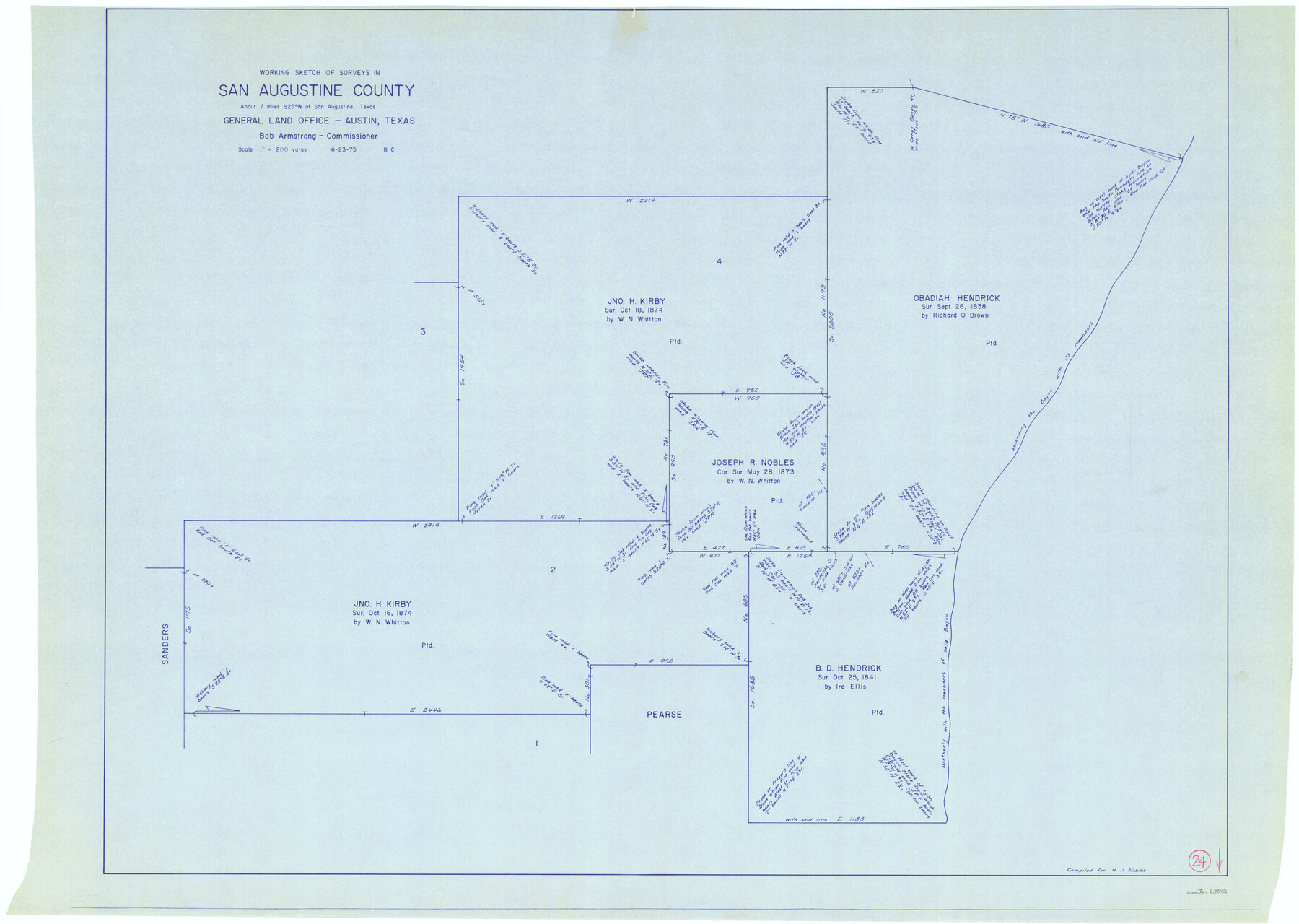
San Augustine County Working Sketch 24
-
Map/Doc
63712
-
Collection
General Map Collection
-
Object Dates
6/23/1975 (Creation Date)
-
People and Organizations
Beverly Christian (Draftsman)
-
Counties
San Augustine
-
Subjects
Surveying Working Sketch
-
Height x Width
27.8 x 39.1 inches
70.6 x 99.3 cm
-
Scale
1" = 200 varas
Part of: General Map Collection
Leon County Working Sketch Graphic Index

Print $20.00
- Digital $50.00
Leon County Working Sketch Graphic Index
1977
Size 46.8 x 41.5 inches
Map/Doc 76618
Harris County Sketch File 96

Print $426.00
- Digital $50.00
Harris County Sketch File 96
1938
Size 26.2 x 36.9 inches
Map/Doc 10484


Flight Mission No. DQN-3K, Frame 4, Calhoun County

Print $20.00
- Digital $50.00
Flight Mission No. DQN-3K, Frame 4, Calhoun County
1953
Size 17.0 x 18.9 inches
Map/Doc 84336
Presidio County Sketch File 6a

Print $2.00
- Digital $50.00
Presidio County Sketch File 6a
Size 7.9 x 6.6 inches
Map/Doc 34437
Harris County Working Sketch 41

Print $20.00
- Digital $50.00
Harris County Working Sketch 41
1940
Size 37.8 x 29.9 inches
Map/Doc 65933
Plat of Division 3 of Day Ranch Lands, Leaday, Texas

Print $20.00
- Digital $50.00
Plat of Division 3 of Day Ranch Lands, Leaday, Texas
Size 20.4 x 21.8 inches
Map/Doc 81514
Map of Erath County

Print $20.00
- Digital $50.00
Map of Erath County
1856
Size 22.4 x 28.0 inches
Map/Doc 3519
Liberty County Sketch File 52

Print $20.00
- Digital $50.00
Liberty County Sketch File 52
Size 17.5 x 13.5 inches
Map/Doc 11995
Palo Pinto County Boundary File 3

Print $58.00
- Digital $50.00
Palo Pinto County Boundary File 3
Size 14.3 x 8.7 inches
Map/Doc 57800
Map of Brown County

Print $40.00
- Digital $50.00
Map of Brown County
1886
Size 48.9 x 41.6 inches
Map/Doc 3342
You may also like
Live Oak County Working Sketch 31

Print $20.00
- Digital $50.00
Live Oak County Working Sketch 31
1991
Size 22.8 x 25.4 inches
Map/Doc 70616
Translations of Titles - Austin's Second Contract, Vol. 3

Translations of Titles - Austin's Second Contract, Vol. 3
1841
Map/Doc 94548

Flight Mission No. DQO-3K, Frame 27, Galveston County

Print $20.00
- Digital $50.00
Flight Mission No. DQO-3K, Frame 27, Galveston County
1952
Size 18.7 x 22.5 inches
Map/Doc 85068
South Part Presidio County

Print $20.00
- Digital $50.00
South Part Presidio County
1975
Size 31.6 x 37.2 inches
Map/Doc 77400
La Salle County Rolled Sketch 23A

Print $225.00
- Digital $50.00
La Salle County Rolled Sketch 23A
1956
Size 10.0 x 15.6 inches
Map/Doc 46481
[Stephen F. Austin's Map of Texas]
![95825, [Stephen F. Austin's Map of Texas], Non-GLO Digital Images](https://historictexasmaps.com/wmedia_w700/maps/95825.tif.jpg)
[Stephen F. Austin's Map of Texas]
1829
Size 21.7 x 17.9 inches
Map/Doc 95825
Webb County Working Sketch 39

Print $20.00
- Digital $50.00
Webb County Working Sketch 39
1941
Size 22.9 x 17.2 inches
Map/Doc 72404
Polk County Rolled Sketch FD

Print $40.00
- Digital $50.00
Polk County Rolled Sketch FD
Size 99.8 x 38.2 inches
Map/Doc 9754
[Sketch showing Blocks B-11, G and M-2 and 3, L, and 47, Sections 77-102]
![91733, [Sketch showing Blocks B-11, G and M-2 and 3, L, and 47, Sections 77-102], Twichell Survey Records](https://historictexasmaps.com/wmedia_w700/maps/91733-1.tif.jpg)
Print $20.00
- Digital $50.00
[Sketch showing Blocks B-11, G and M-2 and 3, L, and 47, Sections 77-102]
Size 25.4 x 18.8 inches
Map/Doc 91733
Cooke County Sketch File 21

Print $4.00
- Digital $50.00
Cooke County Sketch File 21
Size 9.0 x 6.7 inches
Map/Doc 19265
Brewster County Working Sketch 33

Print $20.00
- Digital $50.00
Brewster County Working Sketch 33
1943
Size 32.5 x 38.2 inches
Map/Doc 67567