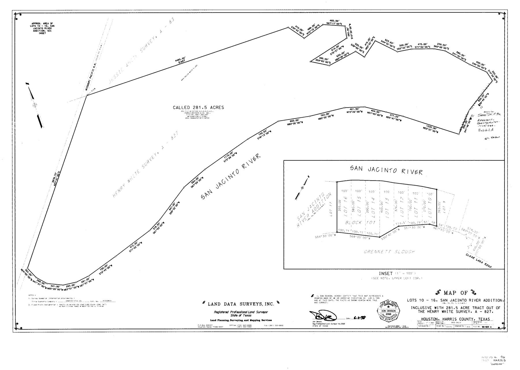
Harris County Sketch File 96
[Correspondence, photostats, USGS quad sheets regarding surveys on San Jacinto River]
-
Map/Doc
10484
-
Collection
General Map Collection
-
Object Dates
1988/2/9 (File Date)
1938 (Creation Date)
1938/6/3 (Survey Date)
1965/11/30 (Correspondence Date)
1970 (Creation Date)
1970/7/24 (Correspondence Date)
1970/8/6 (Correspondence Date)
1987/12/29 (Correspondence Date)
1976 (Creation Date)
1987/9/10 (Correspondence Date)
1835 (Survey Date)
-
People and Organizations
Don Denson (Surveyor/Engineer)
Harry K. Johnson (Surveyor/Engineer)
Jerry Sadler (GLO Commissioner)
Stephen A. Bryan (Surveyor/Engineer)
Jack Giberson (GLO Clerk)
Herman Forbes (Surveyor/Engineer)
LaNell H. Aston (GLO Clerk)
-
Counties
Harris
-
Subjects
Surveying Sketch File
-
Height x Width
26.2 x 36.9 inches
66.6 x 93.7 cm
-
Medium
multi-page, multi-format
-
Features
MP
San Jacinto River
Clear Lake Road
San Jacinto Addition
McCombs Lake
Highlands
I.H. 10
Market Street Road
River Road
Meadowbrook Drive
Moreland Drive
Fairmount Drive
Brookside Drive
Lincoln Drive
Woodloom Street
River Park Street
Riverside Drive
Lake Shore Drive
Old River Road
San Jacinto Terrace
San Jacinto Terrace
San Jacinto River Estates
Lake Sandy Acres
Monmouth Drive
Lake Shady Acres
Magnolia Place
Grinnel Slue [sic]
Whites Lake
Grunnel Slough
Houston
Cedar Bayou
Humble
Warners Bayou
Carpenters Bayou
Baytown
Goose Creek
Little Vince Bayou
Pasadena
Vince Bayou
State Highway 146
I.H. 610
Highway 90
State Road 225
I.H. 35
Hunting Bayou
Clear Lake Street
Lang Road
White Cemetery
Highland Shores Road
George White Lake
Muleshoe Lake
Rio Villa Drive
Wallisville Gully
Bird Lake
Clear Lake
Bear Lake
Diamond Island
Lake Sandy
Bear Bayou
Whiteoak Street
Mantu
Missouri Pacific Railroad Bridge
Lynchburg-Crosby Road
Avenue A
Harris Street
St. Jude's Church
Avenue B
Avenue C
Avenue D
Avenue E
River Bend County Park
Bird Lake
Battle Bell Road
Rio Villa Drive
East Houston Street
Steele Road
Thompson Road
Shady Lane
Crosby
Sheldon
Jacksons Gum Gully
West Camp Lake
Bluff Gully
Fig Orchard Road
Buzzard Lake
Heads Lake
Wallisville
Grennet Slough
McGhee Cemetery
McGhee School
Channelview
Gilbert Landing
Old River
Lost Lake
5th Street
6th Street
7th Street
8th Street
9th Street
10th Street
11th Street
Bennett Oil Lot Subdivision
Roberta Street
Part of: General Map Collection
Angelina County Working Sketch 3

Print $20.00
- Digital $50.00
Angelina County Working Sketch 3
1894
Size 17.9 x 16.6 inches
Map/Doc 67083
Duval County Rolled Sketch 44

Print $20.00
- Digital $50.00
Duval County Rolled Sketch 44
Size 21.2 x 26.5 inches
Map/Doc 8822
Intracoastal Waterway in Texas - Corpus Christi to Point Isabel including Arroyo Colorado to Mo. Pac. R.R. Bridge Near Harlingen

Print $20.00
- Digital $50.00
Intracoastal Waterway in Texas - Corpus Christi to Point Isabel including Arroyo Colorado to Mo. Pac. R.R. Bridge Near Harlingen
1933
Size 27.9 x 41.0 inches
Map/Doc 61868
[Right of Way & Track Map, The Texas & Pacific Ry. Co. Main Line]
![64679, [Right of Way & Track Map, The Texas & Pacific Ry. Co. Main Line], General Map Collection](https://historictexasmaps.com/wmedia_w700/maps/64679.tif.jpg)
Print $20.00
- Digital $50.00
[Right of Way & Track Map, The Texas & Pacific Ry. Co. Main Line]
Size 11.0 x 18.4 inches
Map/Doc 64679
Orange County Working Sketch 33

Print $20.00
- Digital $50.00
Orange County Working Sketch 33
1957
Size 26.1 x 18.4 inches
Map/Doc 71365
Brewster County Rolled Sketch 79

Print $20.00
- Digital $50.00
Brewster County Rolled Sketch 79
Size 36.9 x 28.0 inches
Map/Doc 5244
[University Lands in El Paso County]
![2426, [University Lands in El Paso County], General Map Collection](https://historictexasmaps.com/wmedia_w700/maps/2426.tif.jpg)
Print $20.00
- Digital $50.00
[University Lands in El Paso County]
1886
Size 29.0 x 43.4 inches
Map/Doc 2426
Hemphill County Sketch File 5

Print $8.00
- Digital $50.00
Hemphill County Sketch File 5
1903
Size 11.2 x 8.8 inches
Map/Doc 26295
Calhoun County Rolled Sketch 30

Print $20.00
- Digital $50.00
Calhoun County Rolled Sketch 30
1974
Size 18.5 x 27.6 inches
Map/Doc 5492
Gradient Boundary Survey of Canadian River through portions of Hutchinson & Roberts Counties, Texas

Print $40.00
- Digital $50.00
Gradient Boundary Survey of Canadian River through portions of Hutchinson & Roberts Counties, Texas
1989
Size 39.6 x 139.0 inches
Map/Doc 3120
Travis County State Real Property Sketch 5

Print $20.00
- Digital $50.00
Travis County State Real Property Sketch 5
1990
Size 25.4 x 37.5 inches
Map/Doc 61696

You may also like
Hamilton County Boundary File 2

Print $4.00
- Digital $50.00
Hamilton County Boundary File 2
Size 14.2 x 8.8 inches
Map/Doc 54195
Sterling County Sketch File 15

Print $8.00
- Digital $50.00
Sterling County Sketch File 15
1935
Size 11.1 x 8.8 inches
Map/Doc 37150
Midland County Working Sketch Graphic Index

Print $20.00
- Digital $50.00
Midland County Working Sketch Graphic Index
1930
Size 43.3 x 35.3 inches
Map/Doc 76641
Galveston County NRC Article 33.136 Sketch 16

Print $28.00
- Digital $50.00
Galveston County NRC Article 33.136 Sketch 16
2002
Size 25.3 x 36.2 inches
Map/Doc 78314
Trinity County

Print $20.00
- Digital $50.00
Trinity County
1857
Size 19.2 x 30.8 inches
Map/Doc 4094
Montague County Sketch File 24

Print $20.00
- Digital $50.00
Montague County Sketch File 24
1941
Size 16.2 x 23.3 inches
Map/Doc 12108
Flight Mission No. BRE-1P, Frame 153, Nueces County

Print $20.00
- Digital $50.00
Flight Mission No. BRE-1P, Frame 153, Nueces County
1956
Size 18.5 x 22.5 inches
Map/Doc 86714
Map of Block X in the Name of Jesse F. Cross, Situated in Martin and Dawson Counties, Texas

Print $20.00
- Digital $50.00
Map of Block X in the Name of Jesse F. Cross, Situated in Martin and Dawson Counties, Texas
1908
Size 26.2 x 42.4 inches
Map/Doc 91356
Tom Green County Sketch File 58

Print $6.00
- Digital $50.00
Tom Green County Sketch File 58
Size 15.9 x 9.4 inches
Map/Doc 38225
[Block V and surrounding surveys]
![90293, [Block V and surrounding surveys], Twichell Survey Records](https://historictexasmaps.com/wmedia_w700/maps/90293-1.tif.jpg)
Print $20.00
- Digital $50.00
[Block V and surrounding surveys]
Size 12.0 x 12.6 inches
Map/Doc 90293
Brewster County Rolled Sketch 101

Print $40.00
- Digital $50.00
Brewster County Rolled Sketch 101
1927
Size 73.0 x 44.9 inches
Map/Doc 8923
Childress County

Print $20.00
- Digital $50.00
Childress County
1921
Size 43.8 x 32.6 inches
Map/Doc 66753