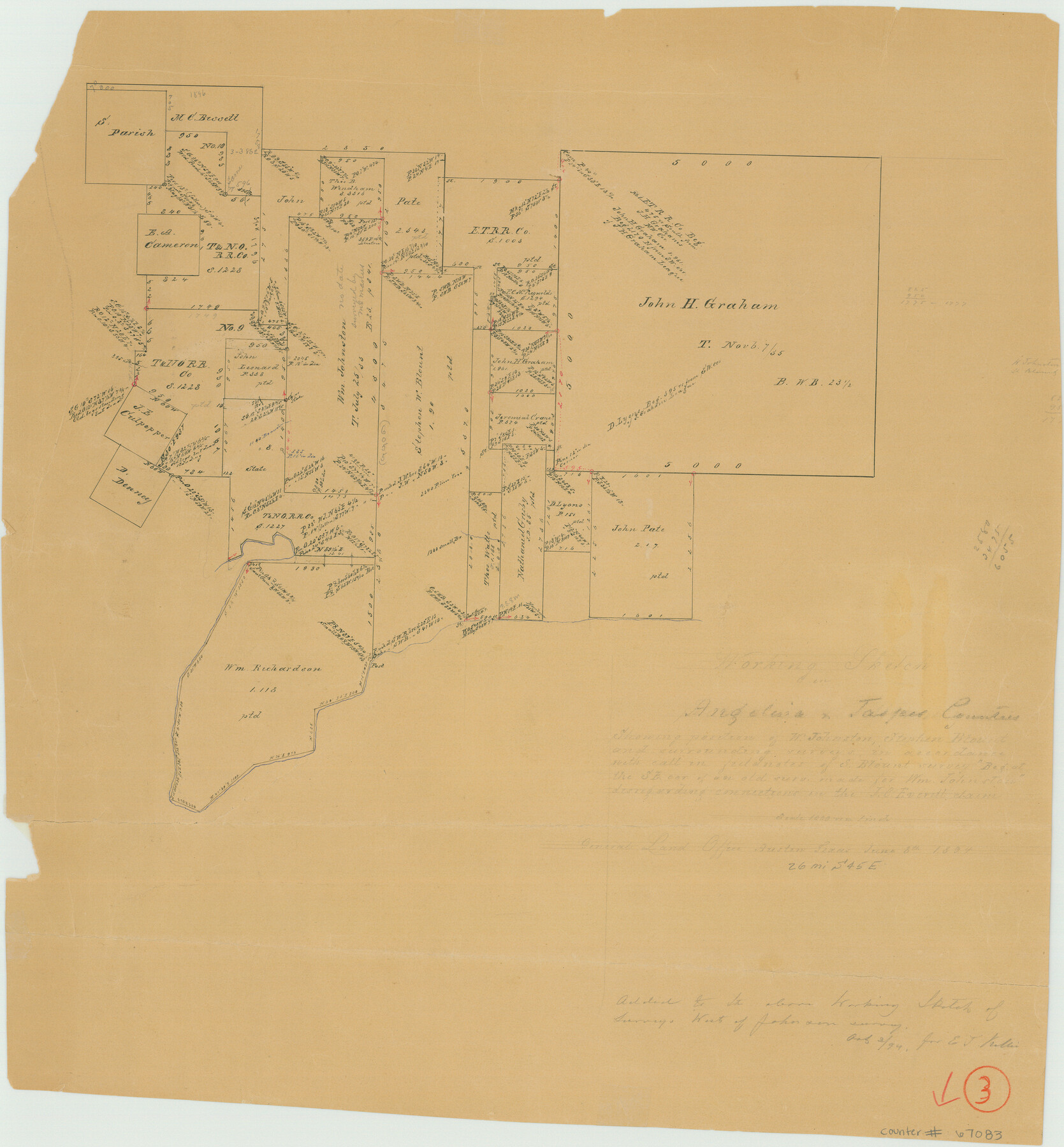
Angelina County Working Sketch 3
-
Map/Doc
67083
-
Collection
General Map Collection
-
Object Dates
6/8/1894 (Creation Date)
-
People and Organizations
Texas General Land Office (Publisher)
-
Counties
Angelina Jasper
-
Subjects
Surveying Working Sketch
-
Height x Width
17.9 x 16.6 inches
45.5 x 42.2 cm
-
Scale
1" = 1000 varas
-
Comments
Surveys located about 26 miles South 45 degrees East from Lufkin, Texas.
Part of: General Map Collection
Presidio County Rolled Sketch 122

Print $20.00
- Digital $50.00
Presidio County Rolled Sketch 122
1981
Size 33.9 x 28.3 inches
Map/Doc 7395
Shelby County Working Sketch 7

Print $20.00
- Digital $50.00
Shelby County Working Sketch 7
1942
Size 40.2 x 44.2 inches
Map/Doc 63860
Goliad County Rolled Sketch 2

Print $20.00
- Digital $50.00
Goliad County Rolled Sketch 2
1944
Size 33.1 x 34.6 inches
Map/Doc 9010
[Travis District]
![88740, [Travis District], General Map Collection](https://historictexasmaps.com/wmedia_w700/maps/88740.tif.jpg)
Print $40.00
- Digital $50.00
[Travis District]
1840
Size 54.7 x 46.0 inches
Map/Doc 88740
Maps of Gulf Intracoastal Waterway, Texas - Sabine River to the Rio Grande and connecting waterways including ship channels

Print $20.00
- Digital $50.00
Maps of Gulf Intracoastal Waterway, Texas - Sabine River to the Rio Grande and connecting waterways including ship channels
1966
Size 14.5 x 22.2 inches
Map/Doc 61928
Flight Mission No. DIX-8P, Frame 68, Aransas County

Print $20.00
- Digital $50.00
Flight Mission No. DIX-8P, Frame 68, Aransas County
1956
Size 18.7 x 22.5 inches
Map/Doc 83899
[Capitol League Surveys in Hartley County, Texas]
![1766, [Capitol League Surveys in Hartley County, Texas], General Map Collection](https://historictexasmaps.com/wmedia_w700/maps/1766.tif.jpg)
Print $20.00
- Digital $50.00
[Capitol League Surveys in Hartley County, Texas]
1910
Size 19.6 x 27.9 inches
Map/Doc 1766
Hamilton County Sketch File 14

Print $10.00
- Digital $50.00
Hamilton County Sketch File 14
Size 10.1 x 8.0 inches
Map/Doc 24937
Williamson County Sketch File 17

Print $8.00
- Digital $50.00
Williamson County Sketch File 17
1876
Size 6.5 x 8.1 inches
Map/Doc 40338
Liberty County Working Sketch 6

Print $20.00
- Digital $50.00
Liberty County Working Sketch 6
1903
Size 17.2 x 19.5 inches
Map/Doc 70465
Rusk County Sketch File 34

Print $20.00
Rusk County Sketch File 34
1949
Size 33.4 x 28.2 inches
Map/Doc 10597
Henderson County Rolled Sketch 11

Print $20.00
- Digital $50.00
Henderson County Rolled Sketch 11
1915
Size 29.4 x 42.5 inches
Map/Doc 75956
You may also like
Nueces County Working Sketch 4

Print $20.00
- Digital $50.00
Nueces County Working Sketch 4
1951
Size 46.8 x 36.2 inches
Map/Doc 71306
Plan C, Part 2nd Shewing that portion of the meridian boundary between Texas and the United States, included between the 36th mile mound and the 72nd north of Sabine River

Print $20.00
- Digital $50.00
Plan C, Part 2nd Shewing that portion of the meridian boundary between Texas and the United States, included between the 36th mile mound and the 72nd north of Sabine River
1842
Size 19.4 x 27.6 inches
Map/Doc 65413
Bexar County Sketch File 52

Print $28.00
- Digital $50.00
Bexar County Sketch File 52
1935
Size 13.5 x 16.8 inches
Map/Doc 14534
Kerr County Working Sketch 24

Print $20.00
- Digital $50.00
Kerr County Working Sketch 24
1966
Size 35.9 x 38.3 inches
Map/Doc 70055
Flight Mission No. DAG-23K, Frame 180, Matagorda County

Print $20.00
- Digital $50.00
Flight Mission No. DAG-23K, Frame 180, Matagorda County
1953
Size 18.4 x 16.0 inches
Map/Doc 86515
Val Verde County Rolled Sketch 60

Print $20.00
- Digital $50.00
Val Verde County Rolled Sketch 60
1951
Size 32.4 x 20.4 inches
Map/Doc 8127
![88913, Map of Brown Co[unty], Library of Congress](https://historictexasmaps.com/wmedia_w700/maps/88913.tif.jpg)
Carte Reduite du Globe Terrestre

Print $20.00
- Digital $50.00
Carte Reduite du Globe Terrestre
1782
Size 13.5 x 17.1 inches
Map/Doc 97117
Callahan County Working Sketch Graphic Index

Print $20.00
- Digital $50.00
Callahan County Working Sketch Graphic Index
1969
Size 41.3 x 33.4 inches
Map/Doc 76485
Map of the country adjacent to the left bank of the Rio Grande below Matamoros

Print $20.00
- Digital $50.00
Map of the country adjacent to the left bank of the Rio Grande below Matamoros
1847
Size 18.3 x 28.1 inches
Map/Doc 72872
Jefferson County Rolled Sketch 21

Print $20.00
- Digital $50.00
Jefferson County Rolled Sketch 21
Size 12.0 x 12.1 inches
Map/Doc 6387
Tracing of J. M. Morgan's Map Showing X-LIT Fence Line

Print $20.00
- Digital $50.00
Tracing of J. M. Morgan's Map Showing X-LIT Fence Line
1916
Size 9.5 x 22.7 inches
Map/Doc 91809