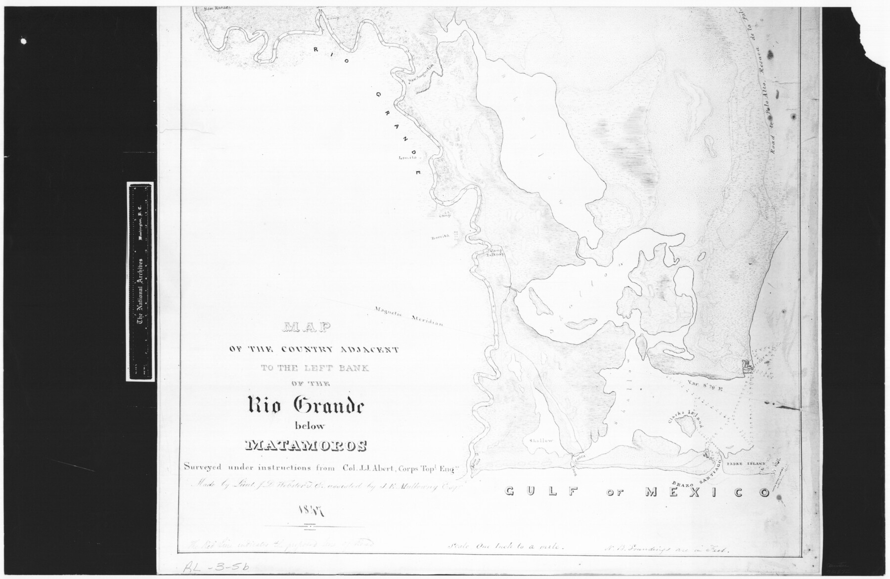
Map of the country adjacent to the left bank of the Rio Grande below Matamoros
RL-3-5b
-
Map/Doc
72872
-
Collection
General Map Collection
-
Object Dates
1847 (Creation Date)
-
People and Organizations
Corps of Topographical Engineers (Author)
J.D. Webster (Surveyor/Engineer)
J.F. Mullowny (Surveyor/Engineer)
-
Subjects
River Surveys
-
Height x Width
18.3 x 28.1 inches
46.5 x 71.4 cm
-
Comments
B/W photostat copy from National Archives in multiple pieces.
Part of: General Map Collection
Ector County Working Sketch 7

Print $40.00
- Digital $50.00
Ector County Working Sketch 7
1941
Size 48.5 x 29.3 inches
Map/Doc 68850
[Beaumont, Sour Lake and Western Ry. Right of Way and Alignment - Frisco]
![64132, [Beaumont, Sour Lake and Western Ry. Right of Way and Alignment - Frisco], General Map Collection](https://historictexasmaps.com/wmedia_w700/maps/64132.tif.jpg)
Print $20.00
- Digital $50.00
[Beaumont, Sour Lake and Western Ry. Right of Way and Alignment - Frisco]
1910
Size 19.9 x 46.1 inches
Map/Doc 64132
Upton County Working Sketch 48

Print $20.00
- Digital $50.00
Upton County Working Sketch 48
1975
Size 29.3 x 24.3 inches
Map/Doc 69544
Flight Mission No. BRA-6M, Frame 99, Jefferson County

Print $20.00
- Digital $50.00
Flight Mission No. BRA-6M, Frame 99, Jefferson County
1953
Size 18.5 x 22.3 inches
Map/Doc 85442
Kaufman County

Print $20.00
- Digital $50.00
Kaufman County
1942
Size 44.5 x 36.7 inches
Map/Doc 77335
Morris County Rolled Sketch 2A

Print $20.00
- Digital $50.00
Morris County Rolled Sketch 2A
Size 24.3 x 19.1 inches
Map/Doc 10239
Wise County Working Sketch 1

Print $20.00
- Digital $50.00
Wise County Working Sketch 1
1929
Size 22.4 x 19.4 inches
Map/Doc 72615
Flight Mission No. DQO-3K, Frame 20, Galveston County

Print $20.00
- Digital $50.00
Flight Mission No. DQO-3K, Frame 20, Galveston County
1952
Size 18.8 x 22.6 inches
Map/Doc 85061
Navigation Maps of Gulf Intracoastal Waterway, Port Arthur to Brownsville, Texas

Print $4.00
- Digital $50.00
Navigation Maps of Gulf Intracoastal Waterway, Port Arthur to Brownsville, Texas
1951
Size 16.6 x 21.5 inches
Map/Doc 65440
Eastland County Working Sketch 47

Print $20.00
- Digital $50.00
Eastland County Working Sketch 47
1981
Size 30.0 x 27.1 inches
Map/Doc 68828
Flight Mission No. BRE-1P, Frame 100, Nueces County

Print $20.00
- Digital $50.00
Flight Mission No. BRE-1P, Frame 100, Nueces County
1956
Size 18.4 x 22.1 inches
Map/Doc 86671
Runnels County Sketch File E

Print $6.00
Runnels County Sketch File E
1895
Size 12.7 x 8.3 inches
Map/Doc 35481
You may also like
Flight Mission No. DQO-2K, Frame 90, Galveston County

Print $20.00
- Digital $50.00
Flight Mission No. DQO-2K, Frame 90, Galveston County
1952
Size 18.8 x 22.6 inches
Map/Doc 85017
Map of Llano County

Print $20.00
- Digital $50.00
Map of Llano County
1871
Size 17.0 x 20.5 inches
Map/Doc 3825
Brazos Santiago, Texas

Print $20.00
- Digital $50.00
Brazos Santiago, Texas
1882
Size 18.3 x 26.0 inches
Map/Doc 72986
Flight Mission No. BRA-8M, Frame 132, Jefferson County

Print $20.00
- Digital $50.00
Flight Mission No. BRA-8M, Frame 132, Jefferson County
1953
Size 18.7 x 22.3 inches
Map/Doc 85628
Jim Hogg County Sketch File 6a

Print $6.00
- Digital $50.00
Jim Hogg County Sketch File 6a
1939
Size 11.1 x 8.7 inches
Map/Doc 28408

Haskell County Sketch File 26

Print $9.00
- Digital $50.00
Haskell County Sketch File 26
1992
Size 11.3 x 8.8 inches
Map/Doc 26182
Bell County Sketch File 29

Print $4.00
- Digital $50.00
Bell County Sketch File 29
1874
Size 13.1 x 8.1 inches
Map/Doc 14439
Baylor County Sketch File 1a

Print $8.00
- Digital $50.00
Baylor County Sketch File 1a
1857
Size 8.2 x 7.9 inches
Map/Doc 14144
Menard County Sketch File 15

Print $8.00
- Digital $50.00
Menard County Sketch File 15
1892
Size 12.9 x 8.3 inches
Map/Doc 31510
Flight Mission No. BQR-9K, Frame 44, Brazoria County

Print $20.00
- Digital $50.00
Flight Mission No. BQR-9K, Frame 44, Brazoria County
1952
Size 18.7 x 22.3 inches
Map/Doc 84048
[Surveys in the vicinity of the Martina Olivares survey]
![90891, [Surveys in the vicinity of the Martina Olivares survey], Twichell Survey Records](https://historictexasmaps.com/wmedia_w700/maps/90891-1.tif.jpg)
Print $3.00
- Digital $50.00
[Surveys in the vicinity of the Martina Olivares survey]
1911
Size 10.3 x 16.9 inches
Map/Doc 90891