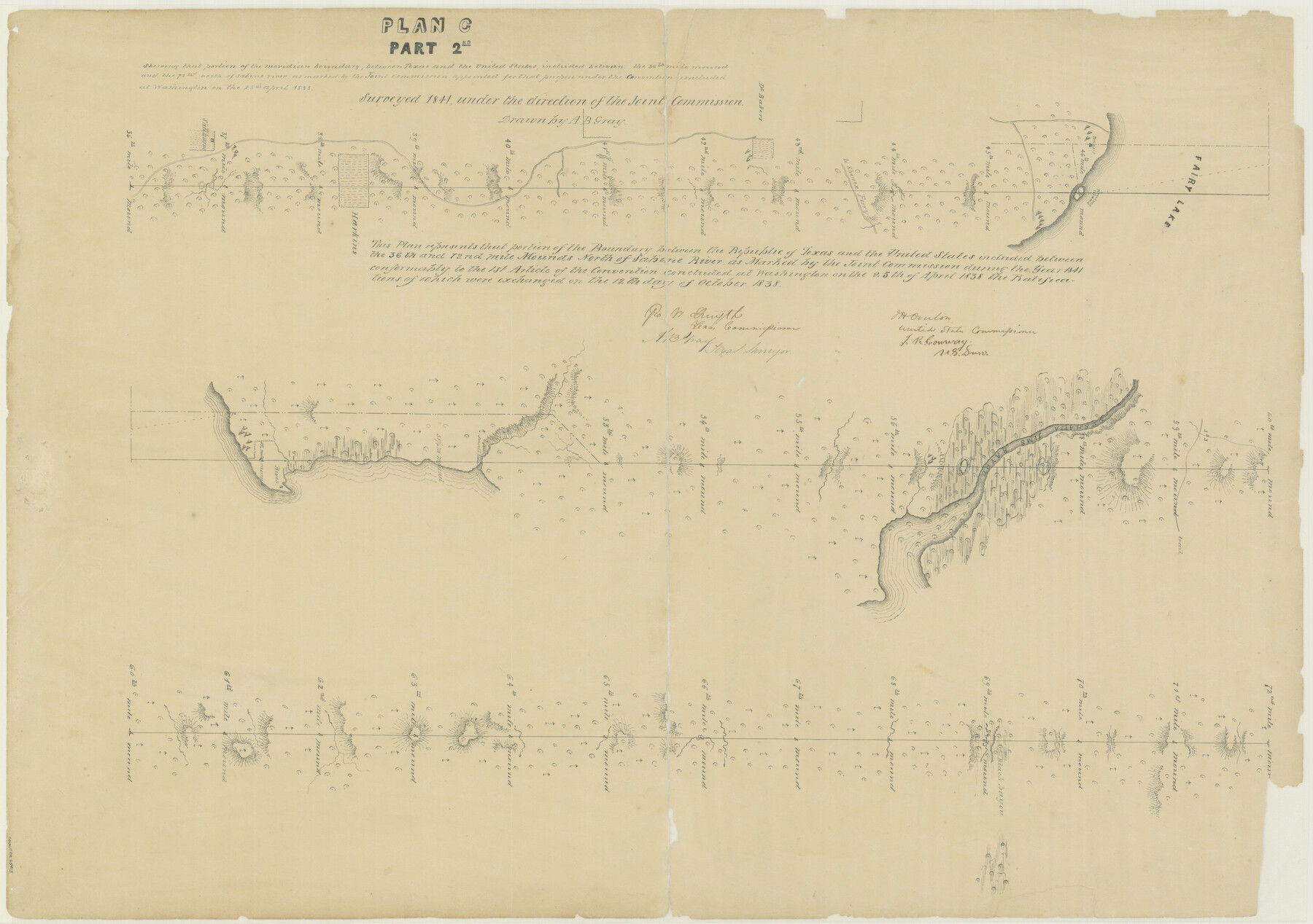
Plan C, Part 2nd Shewing that portion of the meridian boundary between Texas and the United States, included between the 36th mile mound and the 72nd north of Sabine River
K-7-18
-
Map/Doc
65413
-
Collection
General Map Collection
-
Object Dates
1842 (Creation Date)
-
People and Organizations
Joint Boundary Commission (Author)
A.B. Gray (Surveyor/Engineer)
-
Subjects
Texas Boundaries
-
Height x Width
19.4 x 27.6 inches
49.3 x 70.1 cm
-
Comments
Texas version of Joint (Boundary) Commission map. (Streeter, Texas, III: 1441). For US version see map 94004. For a copy of the "Journal of the Joint Commission" see 65515.
Related maps
That part of the boundary between the Republic of Texas and the United States, North of Sabine River from the 36th to the 72nd Mile Mound on the Meridian Line (Sheet No. 2)

Print $20.00
- Digital $50.00
That part of the boundary between the Republic of Texas and the United States, North of Sabine River from the 36th to the 72nd Mile Mound on the Meridian Line (Sheet No. 2)
1842
Size 33.7 x 26.0 inches
Map/Doc 3132
Journal of the Joint Commission

Print $35.00
- Digital $50.00
Journal of the Joint Commission
1838
Size 9.3 x 6.1 inches
Map/Doc 65515
B2 - Part of the Boundary between the United States and Texas North of Sabine River from the 39th [i.e. 36th] to the 72nd mile mound
![94004, B2 - Part of the Boundary between the United States and Texas North of Sabine River from the 39th [i.e. 36th] to the 72nd mile mound, General Map Collection](https://historictexasmaps.com/wmedia_w700/maps/94004-1.tif.jpg)
Print $20.00
- Digital $50.00
B2 - Part of the Boundary between the United States and Texas North of Sabine River from the 39th [i.e. 36th] to the 72nd mile mound
Size 28.6 x 22.2 inches
Map/Doc 94004
Part of: General Map Collection
Liberty County Rolled Sketch I

Print $20.00
- Digital $50.00
Liberty County Rolled Sketch I
1944
Size 38.1 x 38.1 inches
Map/Doc 10642
Flight Mission No. DCL-6C, Frame 130, Kenedy County

Print $20.00
- Digital $50.00
Flight Mission No. DCL-6C, Frame 130, Kenedy County
1943
Size 18.6 x 22.3 inches
Map/Doc 85960
Jack County Working Sketch 1

Print $20.00
- Digital $50.00
Jack County Working Sketch 1
Size 28.4 x 27.1 inches
Map/Doc 66427
Uvalde County Rolled Sketch 24

Print $20.00
- Digital $50.00
Uvalde County Rolled Sketch 24
2014
Size 16.2 x 16.1 inches
Map/Doc 93722
Crockett County Working Sketch 64

Print $20.00
- Digital $50.00
Crockett County Working Sketch 64
1957
Size 19.0 x 25.4 inches
Map/Doc 68397
Brewster County Working Sketch 80

Print $20.00
- Digital $50.00
Brewster County Working Sketch 80
1972
Size 44.3 x 39.1 inches
Map/Doc 67680
Liberty County Sketch File 38

Print $22.00
- Digital $50.00
Liberty County Sketch File 38
1899
Size 13.9 x 8.9 inches
Map/Doc 29983
Nueces County NRC Article 33.136 Sketch 12

Print $80.00
- Digital $50.00
Nueces County NRC Article 33.136 Sketch 12
2000
Size 24.9 x 36.7 inches
Map/Doc 83065
Van Zandt County Working Sketch 2

Print $20.00
- Digital $50.00
Van Zandt County Working Sketch 2
1910
Size 17.8 x 11.6 inches
Map/Doc 72251
Llano County Sketch File 18

Print $20.00
- Digital $50.00
Llano County Sketch File 18
1949
Size 22.3 x 20.0 inches
Map/Doc 12013
Brewster County Rolled Sketch 100

Print $133.00
- Digital $50.00
Brewster County Rolled Sketch 100
1893
Size 10.1 x 15.4 inches
Map/Doc 43055
Mason County Sketch File 3a

Print $4.00
- Digital $50.00
Mason County Sketch File 3a
1877
Size 8.3 x 7.9 inches
Map/Doc 30682
You may also like
Motley County Boundary File 2c

Print $34.00
- Digital $50.00
Motley County Boundary File 2c
Size 14.2 x 8.7 inches
Map/Doc 57533
Stonewall County Sketch File 7

Print $24.00
- Digital $50.00
Stonewall County Sketch File 7
1896
Size 11.4 x 7.4 inches
Map/Doc 37213
Titus County Working Sketch 8

Print $20.00
- Digital $50.00
Titus County Working Sketch 8
1974
Size 17.6 x 29.3 inches
Map/Doc 69369
Brewster County Rolled Sketch 147

Print $20.00
- Digital $50.00
Brewster County Rolled Sketch 147
1986
Size 24.6 x 24.8 inches
Map/Doc 5313
Hall County Rolled Sketch D2

Print $20.00
- Digital $50.00
Hall County Rolled Sketch D2
Size 19.0 x 22.1 inches
Map/Doc 6055
Val Verde County Sketch File P

Print $8.00
- Digital $50.00
Val Verde County Sketch File P
1891
Size 14.3 x 8.8 inches
Map/Doc 39299
Ochiltree County Boundary File 4

Print $4.00
- Digital $50.00
Ochiltree County Boundary File 4
Size 11.1 x 8.7 inches
Map/Doc 57682
Fannin County Sketch File 9a

Print $4.00
- Digital $50.00
Fannin County Sketch File 9a
Size 8.2 x 6.4 inches
Map/Doc 22455
[Capitol lands granted for purpose of building State Capitol]
![2073, [Capitol lands granted for purpose of building State Capitol], General Map Collection](https://historictexasmaps.com/wmedia_w700/maps/2073.tif.jpg)
Print $20.00
- Digital $50.00
[Capitol lands granted for purpose of building State Capitol]
1956
Size 31.5 x 13.0 inches
Map/Doc 2073
Lampasas County Working Sketch 14

Print $20.00
- Digital $50.00
Lampasas County Working Sketch 14
1974
Size 23.4 x 21.8 inches
Map/Doc 70291
Val Verde County Working Sketch 117

Print $20.00
- Digital $50.00
Val Verde County Working Sketch 117
1993
Size 17.5 x 24.4 inches
Map/Doc 82848
San Jacinto County Sketch File 21

Print $2.00
San Jacinto County Sketch File 21
1873
Size 10.4 x 8.4 inches
Map/Doc 35802