Liberty County Rolled Sketch O
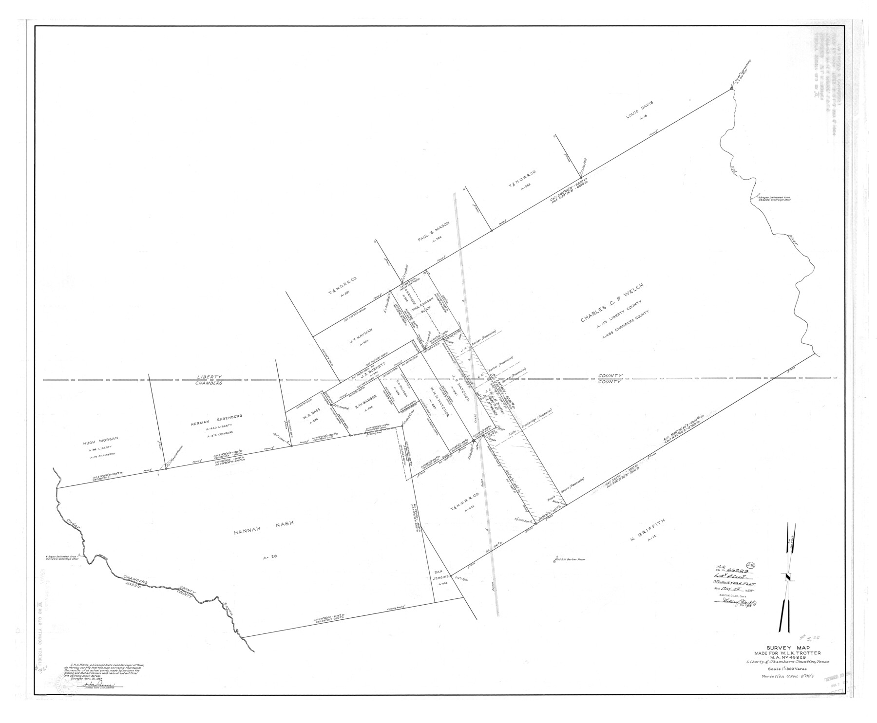
Survey map made for W.L.K. Trotter M.A. no. 46929, Liberty & Chambers Counties, Texas
-
Map/Doc
10183
-
Collection
General Map Collection
-
Object Dates
4/20/1954 (Creation Date)
5/5/1954 (File Date)
-
People and Organizations
H.A. Pierce (Surveyor/Engineer)
-
Counties
Liberty Chambers
-
Subjects
Surveying Rolled Sketch
-
Height x Width
44.3 x 53.7 inches
112.5 x 136.4 cm
Part of: General Map Collection
Hudspeth County Working Sketch 55

Print $20.00
- Digital $50.00
Hudspeth County Working Sketch 55
1989
Size 22.3 x 29.5 inches
Map/Doc 66340
Kent County Sketch File 1

Print $6.00
- Digital $50.00
Kent County Sketch File 1
1882
Size 10.9 x 12.2 inches
Map/Doc 28823
Foard County Sketch File X1

Print $40.00
- Digital $50.00
Foard County Sketch File X1
Size 17.6 x 14.2 inches
Map/Doc 22800
Trinity River, Hughes Crossing Sheet/Chambers Creek

Print $6.00
- Digital $50.00
Trinity River, Hughes Crossing Sheet/Chambers Creek
1931
Size 32.5 x 30.2 inches
Map/Doc 65239
Fannin County Sketch File 13

Print $4.00
- Digital $50.00
Fannin County Sketch File 13
Size 8.1 x 7.9 inches
Map/Doc 22462
Upshur County Working Sketch 5

Print $20.00
- Digital $50.00
Upshur County Working Sketch 5
1941
Size 15.0 x 20.6 inches
Map/Doc 69561
Flight Mission No. DQN-5K, Frame 28, Calhoun County

Print $20.00
- Digital $50.00
Flight Mission No. DQN-5K, Frame 28, Calhoun County
1953
Size 18.5 x 22.1 inches
Map/Doc 84379
El Paso County Working Sketch 6

Print $20.00
- Digital $50.00
El Paso County Working Sketch 6
1928
Size 25.4 x 16.7 inches
Map/Doc 69028
Webb County Sketch File 11a

Print $4.00
- Digital $50.00
Webb County Sketch File 11a
1883
Size 11.2 x 8.7 inches
Map/Doc 39779
Coleman County Working Sketch 5

Print $20.00
- Digital $50.00
Coleman County Working Sketch 5
1928
Size 27.0 x 25.6 inches
Map/Doc 68071
Flight Mission No. DQN-2K, Frame 73, Calhoun County

Print $20.00
- Digital $50.00
Flight Mission No. DQN-2K, Frame 73, Calhoun County
1953
Size 18.5 x 22.2 inches
Map/Doc 84265
[Blocks 341, G-5, G-12, TCRRCo.]
![2069, [Blocks 341, G-5, G-12, TCRRCo.], General Map Collection](https://historictexasmaps.com/wmedia_w700/maps/2069-1.tif.jpg)
Print $20.00
- Digital $50.00
[Blocks 341, G-5, G-12, TCRRCo.]
1954
Size 23.7 x 22.7 inches
Map/Doc 2069
You may also like
[Sections 47-76 and part of Block 3]
![91807, [Sections 47-76 and part of Block 3], Twichell Survey Records](https://historictexasmaps.com/wmedia_w700/maps/91807-1.tif.jpg)
Print $20.00
- Digital $50.00
[Sections 47-76 and part of Block 3]
Size 34.1 x 31.7 inches
Map/Doc 91807
Lee County Boundary File 2

Print $25.00
- Digital $50.00
Lee County Boundary File 2
Size 14.2 x 8.6 inches
Map/Doc 56269
Blanco County Sketch File 50

Print $6.00
- Digital $50.00
Blanco County Sketch File 50
1995
Size 11.5 x 8.8 inches
Map/Doc 14695
Hardin County Sketch File 52

Print $6.00
- Digital $50.00
Hardin County Sketch File 52
Size 11.5 x 8.9 inches
Map/Doc 25210
Comanche County Sketch File 16a

Print $4.00
- Digital $50.00
Comanche County Sketch File 16a
Size 6.1 x 8.5 inches
Map/Doc 19084
Kent County Sketch File 7

Print $20.00
- Digital $50.00
Kent County Sketch File 7
1902
Size 21.7 x 37.6 inches
Map/Doc 10514
Grayson County Working Sketch 9

Print $20.00
- Digital $50.00
Grayson County Working Sketch 9
1946
Size 44.8 x 31.7 inches
Map/Doc 63248
Ellis County Working Sketch 1

Print $20.00
- Digital $50.00
Ellis County Working Sketch 1
1939
Size 19.1 x 19.3 inches
Map/Doc 69017
Hemphill County Rolled Sketch 15

Print $20.00
- Digital $50.00
Hemphill County Rolled Sketch 15
1961
Size 44.7 x 21.5 inches
Map/Doc 6194
Fort Bend County Sketch File 14

Print $24.00
- Digital $50.00
Fort Bend County Sketch File 14
1890
Size 12.3 x 7.4 inches
Map/Doc 22913
Refugio County Boundary File 3

Print $4.00
- Digital $50.00
Refugio County Boundary File 3
Size 14.0 x 8.7 inches
Map/Doc 58244
Controlled Mosaic by Jack Amman Photogrammetric Engineers, Inc - Sheet 20

Print $20.00
- Digital $50.00
Controlled Mosaic by Jack Amman Photogrammetric Engineers, Inc - Sheet 20
1954
Size 19.3 x 24.0 inches
Map/Doc 83469