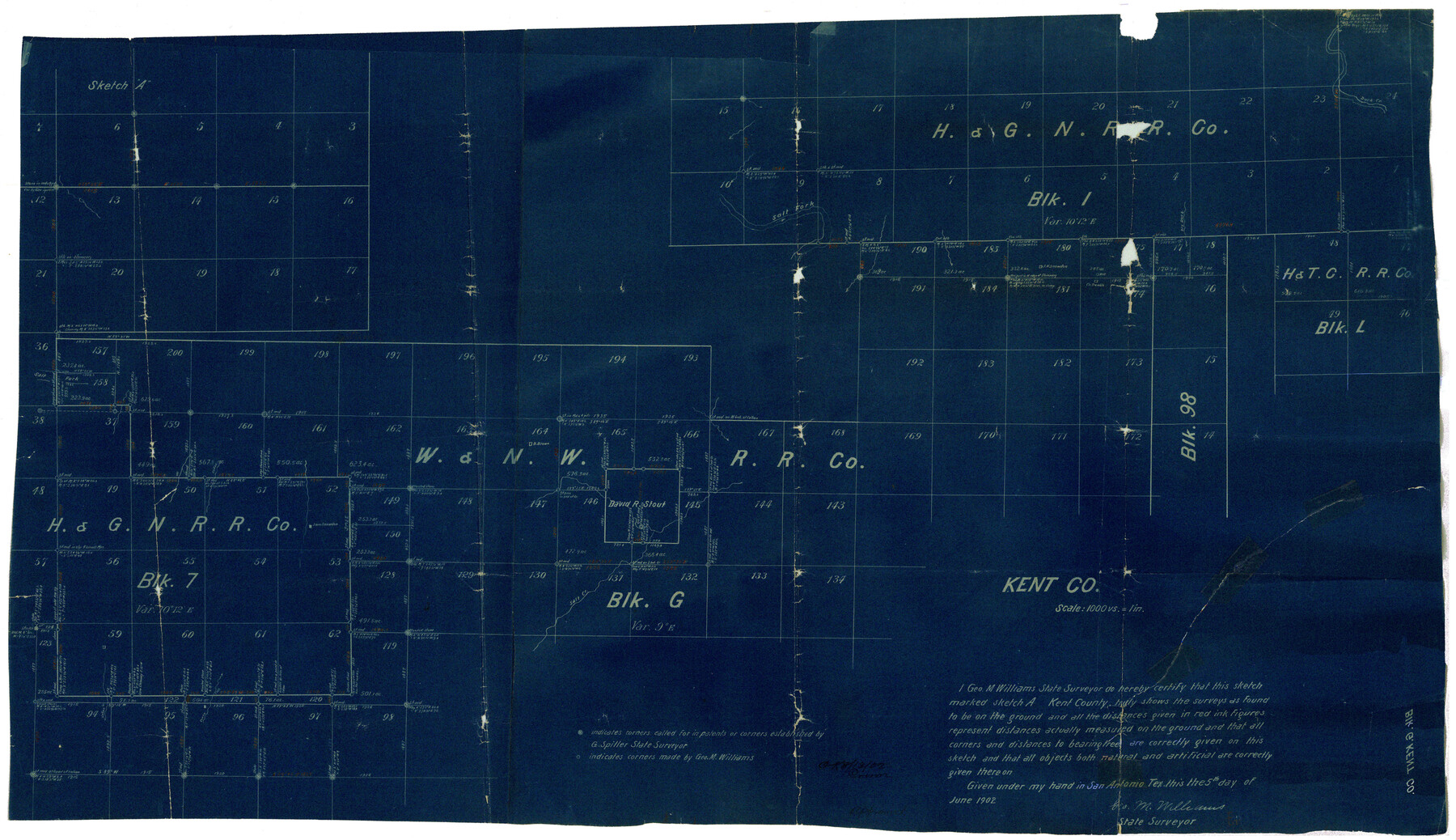
Kent County Sketch File 7
[Sketch of area around David R. Stout survey in western part of the county]
-
Map/Doc
10514
-
Collection
General Map Collection
-
Object Dates
6/5/1902 (Creation Date)
-
People and Organizations
George M. Williams (Surveyor/Engineer)
-
Counties
Kent
-
Subjects
Surveying Sketch File
-
Height x Width
21.7 x 37.6 inches
55.1 x 95.5 cm
-
Medium
blueprint/diazo
-
Features
Duck Creek
Salt Fork [of Brazos River]
Cañon Creek
Part of: General Map Collection
Jefferson County Rolled Sketch 32

Print $40.00
- Digital $50.00
Jefferson County Rolled Sketch 32
1955
Size 26.4 x 49.3 inches
Map/Doc 9295
Hunt County Boundary File 6

Print $6.00
- Digital $50.00
Hunt County Boundary File 6
Size 14.3 x 8.6 inches
Map/Doc 55225
Schleicher County Rolled Sketch 19

Print $20.00
- Digital $50.00
Schleicher County Rolled Sketch 19
Size 25.0 x 21.9 inches
Map/Doc 7761
Val Verde County Working Sketch 73

Print $20.00
- Digital $50.00
Val Verde County Working Sketch 73
1970
Size 37.6 x 34.5 inches
Map/Doc 72208
Childress County Rolled Sketch 19

Print $20.00
- Digital $50.00
Childress County Rolled Sketch 19
2004
Size 24.6 x 18.6 inches
Map/Doc 81937
Houston County Working Sketch 3

Print $20.00
- Digital $50.00
Houston County Working Sketch 3
Size 16.7 x 18.5 inches
Map/Doc 66233
Chambers County Rolled Sketch 30

Print $20.00
- Digital $50.00
Chambers County Rolled Sketch 30
1952
Size 26.8 x 37.8 inches
Map/Doc 5431
Flight Mission No. BRA-7M, Frame 178, Jefferson County

Print $20.00
- Digital $50.00
Flight Mission No. BRA-7M, Frame 178, Jefferson County
1953
Size 18.6 x 22.4 inches
Map/Doc 85546
Wharton County Rolled Sketch 11

Print $20.00
- Digital $50.00
Wharton County Rolled Sketch 11
Size 27.3 x 37.2 inches
Map/Doc 8235
Garza County Rolled Sketch 6E

Print $20.00
- Digital $50.00
Garza County Rolled Sketch 6E
1913
Size 19.2 x 15.6 inches
Map/Doc 5999
Right of Way & Track Map, St. Louis, Brownsville & Mexico Ry. operated by St. Louis, Brownsville & Mexico Ry. Co.

Print $40.00
- Digital $50.00
Right of Way & Track Map, St. Louis, Brownsville & Mexico Ry. operated by St. Louis, Brownsville & Mexico Ry. Co.
1919
Size 25.5 x 57.1 inches
Map/Doc 64615
Live Oak County Sketch File 34

Print $28.00
- Digital $50.00
Live Oak County Sketch File 34
1963
Size 31.0 x 23.9 inches
Map/Doc 12011
You may also like
La Salle County Rolled Sketch 27

Print $20.00
- Digital $50.00
La Salle County Rolled Sketch 27
1979
Size 29.0 x 38.2 inches
Map/Doc 6588
Conoco Official Road Map New Mexico

Print $20.00
- Digital $50.00
Conoco Official Road Map New Mexico
1934
Size 18.5 x 24.4 inches
Map/Doc 92436
Nolan County Working Sketch 9

Print $20.00
- Digital $50.00
Nolan County Working Sketch 9
1964
Size 25.0 x 36.8 inches
Map/Doc 71300
Hudspeth County Working Sketch Graphic Index

Print $40.00
- Digital $50.00
Hudspeth County Working Sketch Graphic Index
1943
Size 53.7 x 39.3 inches
Map/Doc 76584

Kleberg County Rolled Sketch 10-43

Print $20.00
- Digital $50.00
Kleberg County Rolled Sketch 10-43
1951
Size 37.2 x 34.9 inches
Map/Doc 9395
Williamson County Boundary File 3

Print $20.00
- Digital $50.00
Williamson County Boundary File 3
Size 18.5 x 23.6 inches
Map/Doc 60012
Galveston County Boundary File 32a

Print $10.00
- Digital $50.00
Galveston County Boundary File 32a
Size 11.4 x 8.9 inches
Map/Doc 53666
Baylor County Sketch File 1

Print $6.00
- Digital $50.00
Baylor County Sketch File 1
Size 17.5 x 11.4 inches
Map/Doc 14117
Reagan County Rolled Sketch 29B

Print $20.00
- Digital $50.00
Reagan County Rolled Sketch 29B
1955
Size 36.5 x 36.1 inches
Map/Doc 9826
Coryell County Working Sketch Graphic Index

Print $20.00
- Digital $50.00
Coryell County Working Sketch Graphic Index
1936
Size 44.8 x 40.5 inches
Map/Doc 76505
Carson County Working Sketch 4

Print $20.00
- Digital $50.00
Carson County Working Sketch 4
1952
Size 26.1 x 37.0 inches
Map/Doc 67875