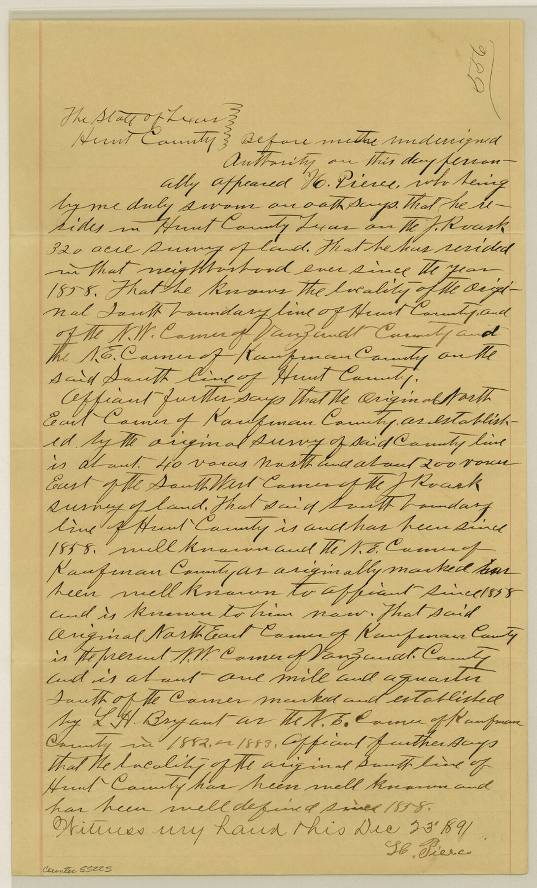
Hunt County Boundary File 6
[Affadavit] Re Hunt & Kaufman Boundary Lines
-
Map/Doc
55225
-
Collection
General Map Collection
-
Counties
Hunt
-
Subjects
County Boundaries
-
Height x Width
14.3 x 8.6 inches
36.3 x 21.8 cm
Part of: General Map Collection
[Map of Upshur County]
![[Map of Upshur County]](https://historictexasmaps.com/wmedia_w700/maps/4651.tif.jpg)
Print $20.00
- Digital $50.00
[Map of Upshur County]
1850
Size 25.2 x 17.8 inches
Map/Doc 4651
Bee County Working Sketch 33

Print $20.00
- Digital $50.00
Bee County Working Sketch 33
1980
Size 32.0 x 28.2 inches
Map/Doc 67284
Hardin County Working Sketch 21

Print $20.00
- Digital $50.00
Hardin County Working Sketch 21
1947
Size 43.2 x 38.4 inches
Map/Doc 63419
Goliad County Working Sketch 24

Print $20.00
- Digital $50.00
Goliad County Working Sketch 24
1982
Size 14.9 x 15.7 inches
Map/Doc 63214
Medina County Working Sketch 19

Print $20.00
- Digital $50.00
Medina County Working Sketch 19
1980
Size 19.4 x 29.1 inches
Map/Doc 70934
Nolan County Sketch File 15

Print $20.00
- Digital $50.00
Nolan County Sketch File 15
1929
Size 24.5 x 22.6 inches
Map/Doc 42165
Trinity River, Kaufman Sheet/Kings Creek

Print $6.00
- Digital $50.00
Trinity River, Kaufman Sheet/Kings Creek
1930
Size 32.6 x 27.0 inches
Map/Doc 65228
Bee County Sketch File 1a

Print $12.00
- Digital $50.00
Bee County Sketch File 1a
1846
Size 9.8 x 6.5 inches
Map/Doc 14359
Moore County Sketch File 7

Print $20.00
- Digital $50.00
Moore County Sketch File 7
Size 24.6 x 45.8 inches
Map/Doc 10553
Chart of the West Indies and Spanish Dominions in North America

Print $20.00
- Digital $50.00
Chart of the West Indies and Spanish Dominions in North America
1803
Size 25.5 x 38.9 inches
Map/Doc 97139
Gregg County Sketch File 1F

Print $4.00
- Digital $50.00
Gregg County Sketch File 1F
1850
Size 12.2 x 7.8 inches
Map/Doc 24547
Nolan County Working Sketch Graphic Index

Print $20.00
- Digital $50.00
Nolan County Working Sketch Graphic Index
1935
Size 41.6 x 36.9 inches
Map/Doc 76654
You may also like
[John H. Stephens Blk. S-2, Capitol Lgs. to North and County School to the South]
![90241, [John H. Stephens Blk. S-2, Capitol Lgs. to North and County School to the South], Twichell Survey Records](https://historictexasmaps.com/wmedia_w700/maps/90241-1.tif.jpg)
Print $20.00
- Digital $50.00
[John H. Stephens Blk. S-2, Capitol Lgs. to North and County School to the South]
1903
Size 20.7 x 18.3 inches
Map/Doc 90241
Jefferson County Working Sketch 9

Print $20.00
- Digital $50.00
Jefferson County Working Sketch 9
1937
Size 19.5 x 22.0 inches
Map/Doc 66552
Llano County Boundary File 3

Print $42.00
- Digital $50.00
Llano County Boundary File 3
Size 14.1 x 8.7 inches
Map/Doc 56449

Jefferson County Rolled Sketch 45

Print $20.00
- Digital $50.00
Jefferson County Rolled Sketch 45
1959
Size 31.2 x 27.3 inches
Map/Doc 6402
Flight Mission No. BQR-20K, Frame 14, Brazoria County

Print $20.00
- Digital $50.00
Flight Mission No. BQR-20K, Frame 14, Brazoria County
1952
Size 18.6 x 22.3 inches
Map/Doc 84116
Borden County, Texas

Print $20.00
- Digital $50.00
Borden County, Texas
1892
Size 25.7 x 20.9 inches
Map/Doc 394
Kendall County Working Sketch 14

Print $20.00
- Digital $50.00
Kendall County Working Sketch 14
1967
Size 37.6 x 33.1 inches
Map/Doc 66686
Cass County Rolled Sketch OPD

Print $20.00
- Digital $50.00
Cass County Rolled Sketch OPD
1936
Size 29.6 x 24.9 inches
Map/Doc 5415
Floyd County Sketch File A

Print $4.00
- Digital $50.00
Floyd County Sketch File A
1893
Size 9.0 x 11.3 inches
Map/Doc 22684
The Republic County of Austin. Proposed, Fall 1837-May 23, 1838

Print $20.00
The Republic County of Austin. Proposed, Fall 1837-May 23, 1838
2020
Size 14.8 x 21.7 inches
Map/Doc 96081
Stonewall County Sketch File 7

Print $24.00
- Digital $50.00
Stonewall County Sketch File 7
1896
Size 11.4 x 7.4 inches
Map/Doc 37213