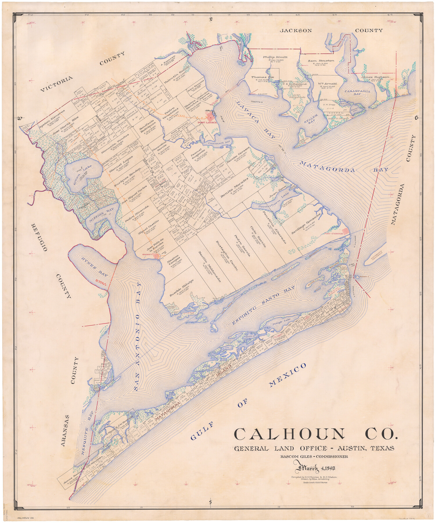
Calhoun Co.
-
Map/Doc
73096
-
Collection
General Map Collection
-
Object Dates
1948/3/4 (Creation Date)
-
People and Organizations
Texas General Land Office (Publisher)
Bascom Giles (GLO Commissioner)
Eltea Armstrong (Draftsman)
R.C. Wisdom (Compiler)
G.C. Morriss (Compiler)
-
Counties
Calhoun
-
Subjects
County
-
Height x Width
49.5 x 41.0 inches
125.7 x 104.1 cm
-
Comments
Hand lettered.
Note on reverse side: "Compilation completed March 4, 1948. Inking completed September 20, 1948. Tracing completed December 30, 1948. Placed in official use January 11, 1949. Total area in square miles 890, June 21, 1951." -
Features
Pelican Island
Powderhorn Lake
Mission Bay
MP
Blackberry Island
Matagorda
Bayucos Island
Seadrift
Hynes Bay
Espiritu Santo Bay
Grass Island
Farwell Island
Green Lake
Long Island
San Antonio Bay
Contee Lake
Pringle Lake
Long Lake
Cory Cove
Pat's Bay
Mustang Lake
Gulf of Mexico
Matagorda Island
Port O'Connor
Cox Point
Swan Lake
Gacitas Cove
Placedo Creek
Huisache Creek
Keller Creek
Well Point
Carancahua Bay
T&NO
Point Comfort
Redfish Lake
Salt Lake
Lavaca River
Chocolate Bayou
Southern Pacific Railroad Company
Port Lavaca
Lavaca Bay
Rhodes Point
Keller Bay
Sand Point
Chocolate Bay
SLB&M
Guadalupe River
Part of: General Map Collection
Brewster County Rolled Sketch 15

Print $20.00
- Digital $50.00
Brewster County Rolled Sketch 15
1889
Size 32.8 x 26.4 inches
Map/Doc 5194
Henderson County Sketch File 19

Print $4.00
- Digital $50.00
Henderson County Sketch File 19
Size 9.1 x 8.9 inches
Map/Doc 26363
Aransas County Sketch File 30

Print $74.00
- Digital $50.00
Aransas County Sketch File 30
Size 14.2 x 8.7 inches
Map/Doc 13237
Orange County Working Sketch 26

Print $20.00
- Digital $50.00
Orange County Working Sketch 26
1953
Size 13.4 x 22.0 inches
Map/Doc 71358
Port of Galveston, Galveston Channel

Print $40.00
- Digital $50.00
Port of Galveston, Galveston Channel
1979
Size 38.0 x 66.2 inches
Map/Doc 83333
Flight Mission No. CLL-1N, Frame 193, Willacy County

Print $20.00
- Digital $50.00
Flight Mission No. CLL-1N, Frame 193, Willacy County
1954
Size 18.4 x 22.2 inches
Map/Doc 87063

Nueces River, Corpus Christi Sheet No. 3

Print $6.00
- Digital $50.00
Nueces River, Corpus Christi Sheet No. 3
1938
Size 31.7 x 25.9 inches
Map/Doc 65091
Webb County Working Sketch 86

Print $20.00
- Digital $50.00
Webb County Working Sketch 86
1981
Size 44.3 x 37.0 inches
Map/Doc 72453
Wilbarger County Sketch File 22

Print $4.00
- Digital $50.00
Wilbarger County Sketch File 22
1889
Size 9.7 x 6.2 inches
Map/Doc 40221
Cherokee County Boundary File 6 and 15

Print $8.00
- Digital $50.00
Cherokee County Boundary File 6 and 15
Size 8.3 x 6.7 inches
Map/Doc 51301
Cooke County Boundary File 3

Print $4.00
- Digital $50.00
Cooke County Boundary File 3
Size 7.3 x 8.7 inches
Map/Doc 51853
You may also like
Map of Taylor County Travis- Young- Bexar- Land District

Print $20.00
- Digital $50.00
Map of Taylor County Travis- Young- Bexar- Land District
1859
Size 25.1 x 20.4 inches
Map/Doc 4071
Jefferson County Working Sketch 21

Print $40.00
- Digital $50.00
Jefferson County Working Sketch 21
1969
Size 31.3 x 60.5 inches
Map/Doc 66564
Nueces County Sketch File 79

Print $16.00
- Digital $50.00
Nueces County Sketch File 79
Size 11.0 x 8.5 inches
Map/Doc 33096
Hemphill County Rolled Sketch 17

Print $20.00
- Digital $50.00
Hemphill County Rolled Sketch 17
1965
Size 23.5 x 39.9 inches
Map/Doc 6199

West Part El Paso Co.

Print $20.00
- Digital $50.00
West Part El Paso Co.
1908
Size 46.8 x 42.4 inches
Map/Doc 4713
Throckmorton County Sketch File 12

Print $20.00
- Digital $50.00
Throckmorton County Sketch File 12
Size 16.2 x 22.3 inches
Map/Doc 12435
Flight Mission No. DIX-10P, Frame 66, Aransas County

Print $20.00
- Digital $50.00
Flight Mission No. DIX-10P, Frame 66, Aransas County
1956
Size 18.8 x 22.5 inches
Map/Doc 83927
Outer Continental Shelf Leasing Maps (Louisiana Offshore Operations)

Print $20.00
- Digital $50.00
Outer Continental Shelf Leasing Maps (Louisiana Offshore Operations)
1959
Size 18.3 x 14.5 inches
Map/Doc 76112
Nacogdoches County Sketch File 5

Print $4.00
- Digital $50.00
Nacogdoches County Sketch File 5
1859
Size 12.6 x 8.1 inches
Map/Doc 32243
Callahan County Sketch File 1

Print $4.00
- Digital $50.00
Callahan County Sketch File 1
Size 9.1 x 8.2 inches
Map/Doc 35851
Garza County Sketch File 26

Print $4.00
- Digital $50.00
Garza County Sketch File 26
Size 10.9 x 8.5 inches
Map/Doc 24095