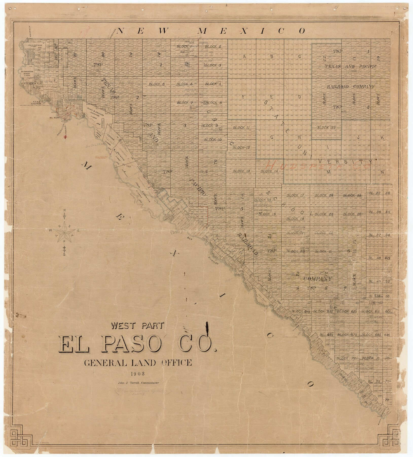
West Part El Paso Co.
-
Map/Doc
4713
-
Collection
General Map Collection
-
Object Dates
1908 (Creation Date)
-
People and Organizations
Texas General Land Office (Publisher)
John J. Terrell (GLO Commissioner)
Fred H. Simonds (Draftsman)
Fred H. Simonds (Compiler)
-
Counties
El Paso
-
Subjects
County
-
Height x Width
46.8 x 42.4 inches
118.9 x 107.7 cm
-
Comments
Conservation funded in 2001 with donation from Lawyers Title of El Paso.
-
Features
Camp Rice
Hot Spring
T&P
Tula
Toreer
La Loma de la Cruz de Juan Antonio
Ysleta
Sierra Blanca
Ojo Caliente
Fort Quitman
Small
Finlay
Hueco Tanks
San Etizario
Rio Grande
Rio Viejo
Socorro
Fort Bliss
El Paso
EP&SW
Southern Pacific Railroad Company
Old Fort Bliss
EP&NE
AT&SF
Part of: General Map Collection
Map of Texas Showing County Names Only

Print $20.00
- Digital $50.00
Map of Texas Showing County Names Only
Size 34.2 x 43.6 inches
Map/Doc 2163
Colorado County Working Sketch 4

Print $20.00
- Digital $50.00
Colorado County Working Sketch 4
1913
Size 23.2 x 16.9 inches
Map/Doc 68104
Lamar County Sketch File 6

Print $40.00
- Digital $50.00
Lamar County Sketch File 6
Size 16.2 x 13.4 inches
Map/Doc 29286
Crane County Sketch File 17

Print $6.00
- Digital $50.00
Crane County Sketch File 17
1927
Size 11.1 x 8.4 inches
Map/Doc 19581
Runnels County Working Sketch 15

Print $20.00
- Digital $50.00
Runnels County Working Sketch 15
1950
Size 22.8 x 18.5 inches
Map/Doc 63611
Dickens County Working Sketch 14

Print $20.00
- Digital $50.00
Dickens County Working Sketch 14
1986
Size 25.5 x 30.7 inches
Map/Doc 62180
Zapata County Rolled Sketch 19

Print $20.00
- Digital $50.00
Zapata County Rolled Sketch 19
1955
Size 29.0 x 20.9 inches
Map/Doc 8316
Fractional Township No. 8 South Range No. 18 East of the Indian Meridian, Indian Territory

Print $20.00
- Digital $50.00
Fractional Township No. 8 South Range No. 18 East of the Indian Meridian, Indian Territory
1897
Size 19.2 x 24.3 inches
Map/Doc 75233
Val Verde County Sketch File 50

Print $8.00
- Digital $50.00
Val Verde County Sketch File 50
1956
Size 11.5 x 8.9 inches
Map/Doc 39316
Howard County Working Sketch 9a

Print $20.00
- Digital $50.00
Howard County Working Sketch 9a
1962
Size 34.8 x 32.8 inches
Map/Doc 66276
Coleman County Sketch File 2

Print $2.00
- Digital $50.00
Coleman County Sketch File 2
Size 8.4 x 3.3 inches
Map/Doc 18669
Concho County Rolled Sketch 12

Print $40.00
- Digital $50.00
Concho County Rolled Sketch 12
1958
Size 36.4 x 50.6 inches
Map/Doc 8657
You may also like
Loving County

Print $20.00
- Digital $50.00
Loving County
1889
Size 24.6 x 19.6 inches
Map/Doc 91385
Lubbock County Rolled Sketch 5

Print $20.00
- Digital $50.00
Lubbock County Rolled Sketch 5
Size 19.8 x 14.2 inches
Map/Doc 6641
Austin County Sketch File 12

Print $40.00
- Digital $50.00
Austin County Sketch File 12
Size 22.5 x 18.0 inches
Map/Doc 10876
Controlled Mosaic by Jack Amman Photogrammetric Engineers, Inc - Sheet 10

Print $20.00
- Digital $50.00
Controlled Mosaic by Jack Amman Photogrammetric Engineers, Inc - Sheet 10
1954
Size 20.0 x 24.0 inches
Map/Doc 83454
Leon County Sketch File 6

Print $4.00
- Digital $50.00
Leon County Sketch File 6
1859
Size 8.2 x 12.0 inches
Map/Doc 29719
Presidio County Rolled Sketch S

Print $20.00
- Digital $50.00
Presidio County Rolled Sketch S
1915
Size 15.6 x 15.4 inches
Map/Doc 7413
Stephens County Working Sketch 39

Print $20.00
- Digital $50.00
Stephens County Working Sketch 39
1995
Size 25.5 x 27.1 inches
Map/Doc 63982
Houston County Sketch File 9

Print $4.00
- Digital $50.00
Houston County Sketch File 9
1857
Size 12.7 x 8.1 inches
Map/Doc 26771
Coke County Sketch File 36

Print $24.00
- Digital $50.00
Coke County Sketch File 36
1918
Size 14.1 x 8.5 inches
Map/Doc 18652
Flight Mission No. CRE-1R, Frame 4, Jackson County

Print $20.00
- Digital $50.00
Flight Mission No. CRE-1R, Frame 4, Jackson County
1956
Size 18.5 x 22.3 inches
Map/Doc 85324
Hartley County Sketch File 4

Print $6.00
- Digital $50.00
Hartley County Sketch File 4
1883
Size 10.6 x 8.1 inches
Map/Doc 26087
Brewster County Working Sketch 81

Print $20.00
- Digital $50.00
Brewster County Working Sketch 81
1972
Size 45.9 x 26.7 inches
Map/Doc 67681