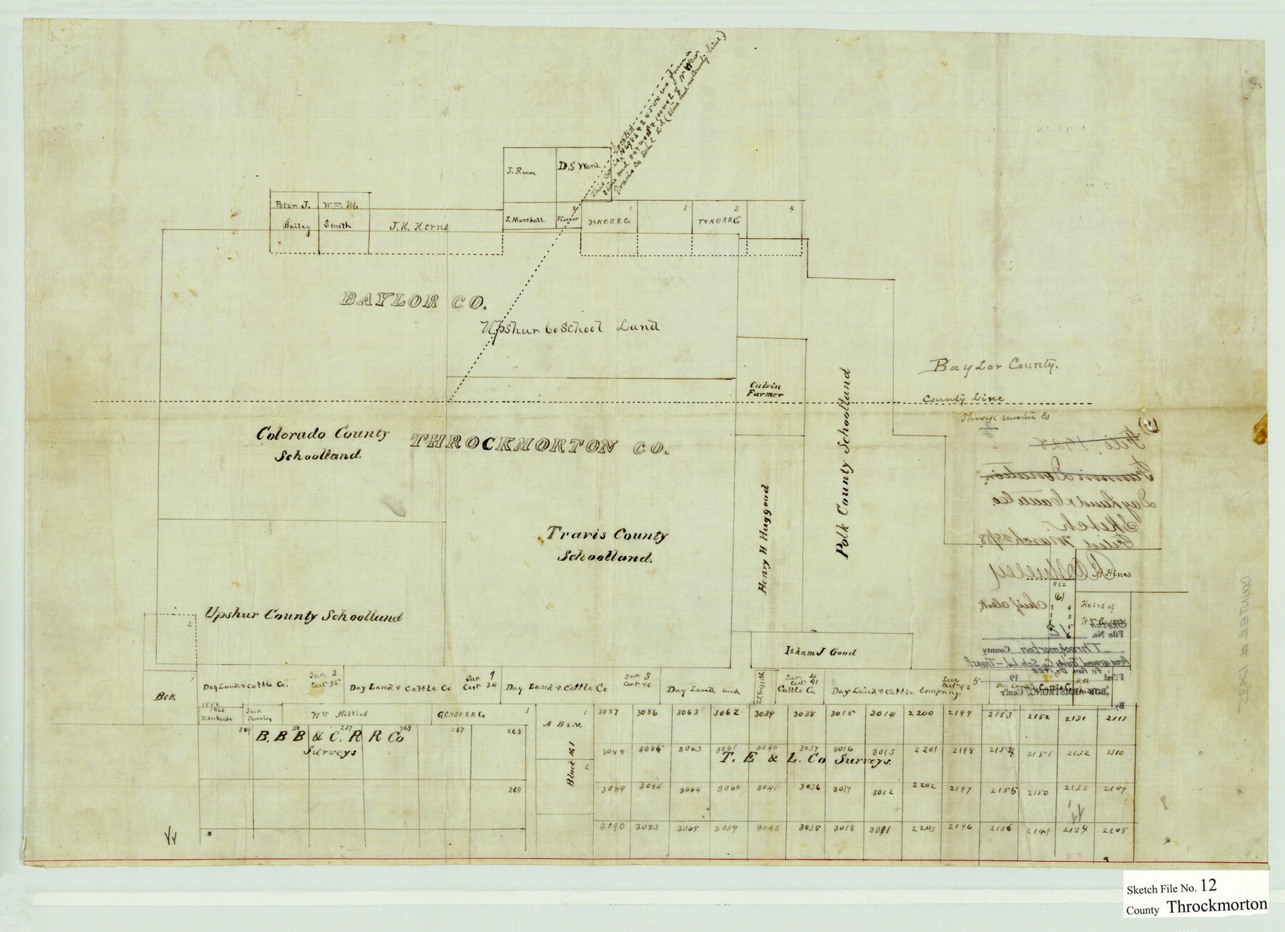
Throckmorton County Sketch File 12
Area Around Travis County School Land, Throckmorton County, Texas
-
Map/Doc
12435
-
Collection
General Map Collection
-
Counties
Throckmorton Baylor
-
Subjects
Surveying Sketch File
-
Height x Width
16.2 x 22.3 inches
41.2 x 56.6 cm
-
Medium
paper, manuscript
Part of: General Map Collection
Flight Mission No. DIX-6P, Frame 121, Aransas County

Print $20.00
- Digital $50.00
Flight Mission No. DIX-6P, Frame 121, Aransas County
1956
Size 18.9 x 22.6 inches
Map/Doc 83827
Collin County Texas

Print $20.00
- Digital $50.00
Collin County Texas
1895
Size 20.7 x 17.5 inches
Map/Doc 794
Jefferson County Rolled Sketch 15

Print $147.00
- Digital $50.00
Jefferson County Rolled Sketch 15
1931
Size 10.0 x 15.2 inches
Map/Doc 46298
Lubbock County Working Sketch 9

Print $40.00
- Digital $50.00
Lubbock County Working Sketch 9
1990
Size 28.5 x 57.3 inches
Map/Doc 70669
Flight Mission No. BRA-16M, Frame 62, Jefferson County

Print $20.00
- Digital $50.00
Flight Mission No. BRA-16M, Frame 62, Jefferson County
1953
Size 18.7 x 22.4 inches
Map/Doc 85679
Val Verde County Working Sketch 14

Print $20.00
- Digital $50.00
Val Verde County Working Sketch 14
1926
Size 17.2 x 18.9 inches
Map/Doc 72149
[Sketch for Mineral Application 24072, San Jacinto River]
![65603, [Sketch for Mineral Application 24072, San Jacinto River], General Map Collection](https://historictexasmaps.com/wmedia_w700/maps/65603.tif.jpg)
Print $20.00
- Digital $50.00
[Sketch for Mineral Application 24072, San Jacinto River]
1929
Size 23.4 x 17.6 inches
Map/Doc 65603
Map of Wise County

Print $20.00
- Digital $50.00
Map of Wise County
1895
Size 41.8 x 37.2 inches
Map/Doc 16932
Flight Mission No. BRE-2P, Frame 106, Nueces County

Print $20.00
- Digital $50.00
Flight Mission No. BRE-2P, Frame 106, Nueces County
1956
Size 18.7 x 22.8 inches
Map/Doc 86791
El Paso County Boundary File 4a

Print $44.00
- Digital $50.00
El Paso County Boundary File 4a
Size 14.1 x 8.6 inches
Map/Doc 53044
Fisher County Sketch File 10

Print $20.00
- Digital $50.00
Fisher County Sketch File 10
Size 9.7 x 37.0 inches
Map/Doc 11477
Flight Mission No. CUI-1H, Frame 97, Milam County

Print $20.00
- Digital $50.00
Flight Mission No. CUI-1H, Frame 97, Milam County
1951
Size 18.5 x 22.2 inches
Map/Doc 86605
You may also like
Map of the Denison & South Eastern Rwy. showing the Location & Land Lines of the First Twenty-One Miles

Print $40.00
- Digital $50.00
Map of the Denison & South Eastern Rwy. showing the Location & Land Lines of the First Twenty-One Miles
1878
Size 24.1 x 70.4 inches
Map/Doc 64023
Aransas County Rolled Sketch 27

Print $20.00
- Digital $50.00
Aransas County Rolled Sketch 27
1983
Size 24.9 x 35.4 inches
Map/Doc 5059
Medina County Working Sketch 20

Print $20.00
- Digital $50.00
Medina County Working Sketch 20
1980
Size 25.4 x 39.2 inches
Map/Doc 70935
Caldwell County

Print $20.00
- Digital $50.00
Caldwell County
1935
Size 38.7 x 42.7 inches
Map/Doc 95444
Angelina County Working Sketch 28

Print $20.00
- Digital $50.00
Angelina County Working Sketch 28
1954
Size 28.9 x 26.0 inches
Map/Doc 67110
Andrews County Rolled Sketch 9

Print $20.00
- Digital $50.00
Andrews County Rolled Sketch 9
1930
Size 25.3 x 43.6 inches
Map/Doc 77160
Archer County Sketch File 10

Print $5.00
- Digital $50.00
Archer County Sketch File 10
Size 10.2 x 15.9 inches
Map/Doc 13642
Carta Historica y Arqueologica

Print $20.00
- Digital $50.00
Carta Historica y Arqueologica
Size 26.0 x 34.4 inches
Map/Doc 96806
Matagorda County

Print $40.00
- Digital $50.00
Matagorda County
1920
Size 39.7 x 49.1 inches
Map/Doc 77368
Brazoria County Rolled Sketch 36

Print $20.00
- Digital $50.00
Brazoria County Rolled Sketch 36
Size 18.5 x 25.0 inches
Map/Doc 5172
Dickens County Working Sketch 13

Print $20.00
- Digital $50.00
Dickens County Working Sketch 13
1981
Size 26.8 x 21.4 inches
Map/Doc 68661
Crockett County Working Sketch Graphic Index - northwest part - sheet B

Print $20.00
- Digital $50.00
Crockett County Working Sketch Graphic Index - northwest part - sheet B
1983
Size 36.2 x 47.7 inches
Map/Doc 76510