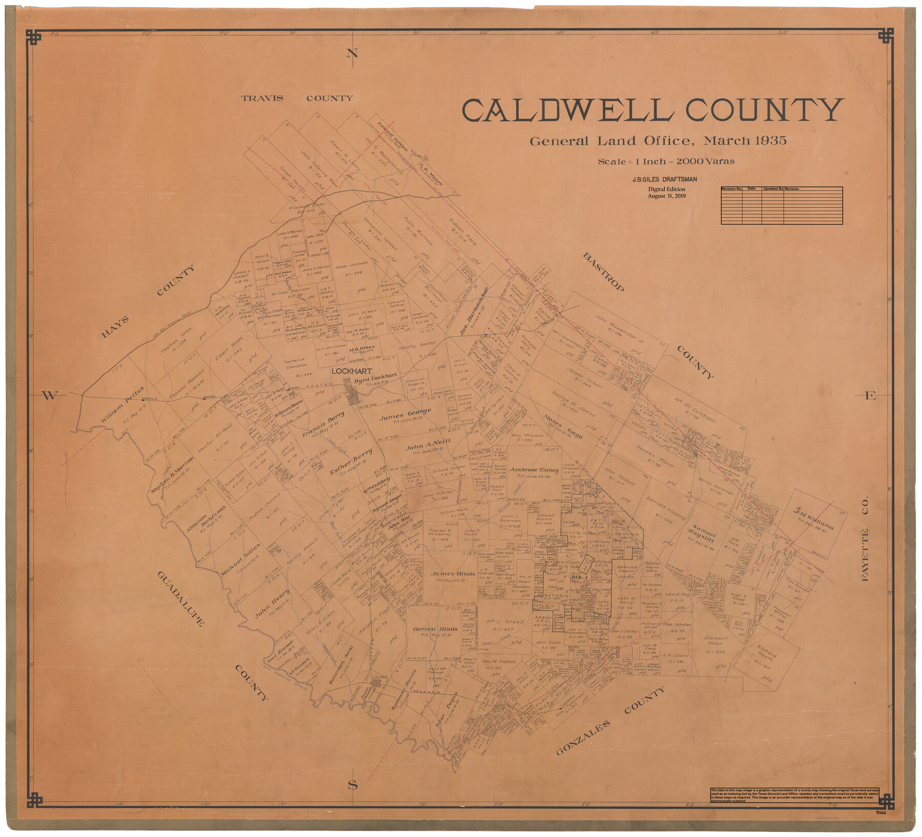
Caldwell County
General Land Office Official County Map
-
Map/Doc
95444
-
Collection
General Map Collection
-
Object Dates
2019/8/31 (Revision Date)
1935 (Creation Date)
-
People and Organizations
Cheyenne Betancourt (Draftsman)
J.B. Giles (Draftsman)
-
Counties
Caldwell
-
Subjects
County OCM
-
Height x Width
38.7 x 42.7 inches
98.3 x 108.5 cm
-
Medium
digital image
-
Scale
1" = 2000 varas
Part of: General Map Collection
Fort Bend County Working Sketch 3

Print $20.00
- Digital $50.00
Fort Bend County Working Sketch 3
1897
Size 26.8 x 24.6 inches
Map/Doc 69209
Howard County Working Sketch Graphic Index

Print $20.00
- Digital $50.00
Howard County Working Sketch Graphic Index
1922
Size 42.5 x 36.3 inches
Map/Doc 76583
Flight Mission No. BRA-16M, Frame 60, Jefferson County

Print $20.00
- Digital $50.00
Flight Mission No. BRA-16M, Frame 60, Jefferson County
1953
Size 18.6 x 22.3 inches
Map/Doc 85677
Kent County Rolled Sketch 2

Print $20.00
- Digital $50.00
Kent County Rolled Sketch 2
1950
Size 22.6 x 40.8 inches
Map/Doc 6473
Map of Asylum Lands

Print $20.00
- Digital $50.00
Map of Asylum Lands
1857
Size 28.4 x 18.5 inches
Map/Doc 2459
Freestone County Working Sketch 14

Print $20.00
- Digital $50.00
Freestone County Working Sketch 14
1980
Size 37.4 x 38.9 inches
Map/Doc 69256

Flight Mission No. DQN-3K, Frame 5, Calhoun County

Print $20.00
- Digital $50.00
Flight Mission No. DQN-3K, Frame 5, Calhoun County
1953
Size 18.4 x 22.1 inches
Map/Doc 84337

[San Antonio & Aransas Pass]
![64209, [San Antonio & Aransas Pass], General Map Collection](https://historictexasmaps.com/wmedia_w700/maps/64209.tif.jpg)
Print $20.00
- Digital $50.00
[San Antonio & Aransas Pass]
Size 15.2 x 45.5 inches
Map/Doc 64209
Atascosa County Working Sketch 35

Print $20.00
- Digital $50.00
Atascosa County Working Sketch 35
1992
Size 34.6 x 48.1 inches
Map/Doc 67231
Flight Mission No. DQN-5K, Frame 78, Calhoun County

Print $20.00
- Digital $50.00
Flight Mission No. DQN-5K, Frame 78, Calhoun County
1953
Size 18.6 x 22.3 inches
Map/Doc 84411
You may also like
King County Boundary File 2

Print $54.00
- Digital $50.00
King County Boundary File 2
Size 8.8 x 7.7 inches
Map/Doc 64887
Polk County Sketch File 12a

Print $4.00
- Digital $50.00
Polk County Sketch File 12a
Size 6.1 x 6.4 inches
Map/Doc 34148
Flight Mission No. CRC-4R, Frame 100, Chambers County

Print $20.00
- Digital $50.00
Flight Mission No. CRC-4R, Frame 100, Chambers County
1956
Size 18.5 x 22.2 inches
Map/Doc 84897
Culberson County Sketch File 5

Print $4.00
- Digital $50.00
Culberson County Sketch File 5
Size 9.4 x 8.2 inches
Map/Doc 20136
Upton County Working Sketch 25

Print $20.00
- Digital $50.00
Upton County Working Sketch 25
1953
Size 38.2 x 31.2 inches
Map/Doc 69521
Pecos County Sketch File 113

Print $10.00
- Digital $50.00
Pecos County Sketch File 113
Size 11.3 x 8.7 inches
Map/Doc 34069
Flight Mission No. DAG-24K, Frame 136, Matagorda County

Print $20.00
- Digital $50.00
Flight Mission No. DAG-24K, Frame 136, Matagorda County
1953
Size 18.4 x 22.2 inches
Map/Doc 86554
Knox County Sketch File 30

Print $15.00
- Digital $50.00
Knox County Sketch File 30
1904
Size 8.2 x 5.2 inches
Map/Doc 29264
Hall County Working Sketch 3

Print $20.00
- Digital $50.00
Hall County Working Sketch 3
1916
Size 15.6 x 17.1 inches
Map/Doc 63331
Duval County Sketch File 76

Print $20.00
- Digital $50.00
Duval County Sketch File 76
1959
Size 15.1 x 27.3 inches
Map/Doc 11410
Morris County Rolled Sketch 2A

Print $20.00
- Digital $50.00
Morris County Rolled Sketch 2A
Size 36.5 x 20.0 inches
Map/Doc 10283
Jackson County Working Sketch 2

Print $20.00
- Digital $50.00
Jackson County Working Sketch 2
1937
Size 41.5 x 38.0 inches
Map/Doc 66450