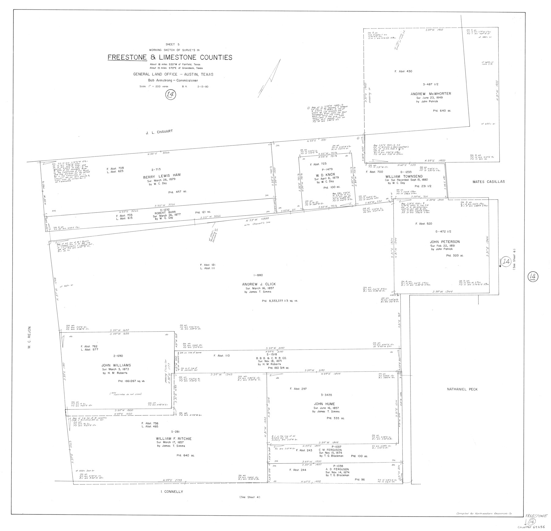
Freestone County Working Sketch 14
-
Map/Doc
69256
-
Collection
General Map Collection
-
Object Dates
2/13/1980 (Creation Date)
-
People and Organizations
Beverly Robison (Draftsman)
-
Counties
Freestone Limestone
-
Subjects
Surveying Working Sketch
-
Height x Width
37.4 x 38.9 inches
95.0 x 98.8 cm
-
Scale
1" = 200 varas
Part of: General Map Collection
McMullen County Rolled Sketch 9

Print $20.00
- Digital $50.00
McMullen County Rolled Sketch 9
Size 34.4 x 40.9 inches
Map/Doc 6726
East Part of Jeff Davis Co.

Print $20.00
- Digital $50.00
East Part of Jeff Davis Co.
1977
Size 40.6 x 30.9 inches
Map/Doc 77327
Falls County Sketch File 15

Print $4.00
- Digital $50.00
Falls County Sketch File 15
Size 13.0 x 8.2 inches
Map/Doc 22372
Dimmit County Sketch File 3

Print $4.00
- Digital $50.00
Dimmit County Sketch File 3
1874
Size 10.1 x 8.0 inches
Map/Doc 21058
Cooke County Sketch File 16-17-18

Print $16.00
- Digital $50.00
Cooke County Sketch File 16-17-18
1860
Size 12.7 x 8.1 inches
Map/Doc 19252
Foard County Rolled Sketch 14 1/2

Print $20.00
- Digital $50.00
Foard County Rolled Sketch 14 1/2
1888
Size 20.8 x 37.4 inches
Map/Doc 5889
Denton County Boundary File 1a

Print $24.00
- Digital $50.00
Denton County Boundary File 1a
Size 12.4 x 8.1 inches
Map/Doc 52401
Brazoria County Rolled Sketch 41

Print $20.00
- Digital $50.00
Brazoria County Rolled Sketch 41
Size 30.3 x 21.3 inches
Map/Doc 5176
Stonewall County Working Sketch 31

Print $20.00
- Digital $50.00
Stonewall County Working Sketch 31
1983
Size 42.6 x 42.9 inches
Map/Doc 62338
Aransas County Rolled Sketch 1

Print $40.00
- Digital $50.00
Aransas County Rolled Sketch 1
1930
Size 16.6 x 53.4 inches
Map/Doc 8404
Denton County Working Sketch 26

Print $20.00
- Digital $50.00
Denton County Working Sketch 26
1995
Size 29.3 x 33.9 inches
Map/Doc 68631
Wichita County Working Sketch 8

Print $20.00
- Digital $50.00
Wichita County Working Sketch 8
1919
Size 18.3 x 37.7 inches
Map/Doc 72517
You may also like

Map Showing Block HG and Connecting Surveys

Print $2.00
- Digital $50.00
Map Showing Block HG and Connecting Surveys
1907
Size 9.2 x 13.7 inches
Map/Doc 90681
[Sketch showing Runnels County School Land survey and surrounding surveys]
![93112, [Sketch showing Runnels County School Land survey and surrounding surveys], Twichell Survey Records](https://historictexasmaps.com/wmedia_w700/maps/93112-1.tif.jpg)
Print $20.00
- Digital $50.00
[Sketch showing Runnels County School Land survey and surrounding surveys]
Size 21.4 x 14.3 inches
Map/Doc 93112
Flight Mission No. BQR-20K, Frame 4, Brazoria County

Print $20.00
- Digital $50.00
Flight Mission No. BQR-20K, Frame 4, Brazoria County
1952
Size 18.8 x 22.4 inches
Map/Doc 84106
Potter County Sketch File 6

Print $20.00
- Digital $50.00
Potter County Sketch File 6
1900
Size 34.4 x 29.0 inches
Map/Doc 10575
Val Verde County Sketch File XXX10

Print $20.00
- Digital $50.00
Val Verde County Sketch File XXX10
Size 25.9 x 19.2 inches
Map/Doc 12549
Runnels County Sketch File 3

Print $4.00
Runnels County Sketch File 3
1871
Size 13.0 x 8.1 inches
Map/Doc 35432
Flight Mission No. DIX-5P, Frame 148, Aransas County

Print $20.00
- Digital $50.00
Flight Mission No. DIX-5P, Frame 148, Aransas County
1956
Size 17.9 x 18.0 inches
Map/Doc 83810
Sutton County Sketch File 42

Print $6.00
- Digital $50.00
Sutton County Sketch File 42
1940
Size 11.2 x 8.8 inches
Map/Doc 37509
Right of Way and Track Map of The Missouri, Kansas & Texas Railway of Texas

Print $40.00
- Digital $50.00
Right of Way and Track Map of The Missouri, Kansas & Texas Railway of Texas
1918
Size 25.2 x 51.6 inches
Map/Doc 64530
Maverick County Rolled Sketch 21

Print $20.00
- Digital $50.00
Maverick County Rolled Sketch 21
Size 24.6 x 28.6 inches
Map/Doc 6713
