Maverick County Rolled Sketch 21
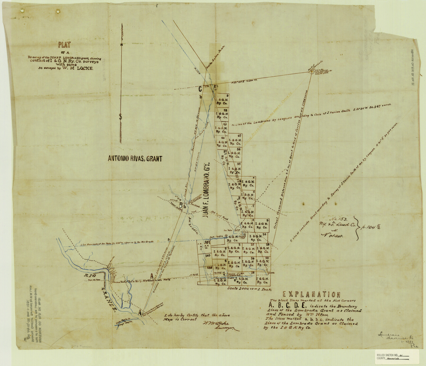
Plat of a re-survey of the Juan F. Lombrano grant, showing conflict of I. & G. N. Ry. Co. surveys with same
-
Map/Doc
6713
-
Collection
General Map Collection
-
People and Organizations
W.M. Locke (Surveyor/Engineer)
-
Counties
Maverick Dimmit
-
Subjects
Surveying Rolled Sketch
-
Height x Width
24.6 x 28.6 inches
62.5 x 72.6 cm
-
Medium
linen, manuscript
Part of: General Map Collection
Right of Way and Track Map of The Missouri, Kansas & Texas Railway of Texas

Print $40.00
- Digital $50.00
Right of Way and Track Map of The Missouri, Kansas & Texas Railway of Texas
1918
Size 24.8 x 52.6 inches
Map/Doc 64529
Hopkins County Sketch File 10a

Print $4.00
- Digital $50.00
Hopkins County Sketch File 10a
1856
Size 12.2 x 7.8 inches
Map/Doc 26702
Roberts County Boundary File 2c

Print $28.00
- Digital $50.00
Roberts County Boundary File 2c
Size 9.5 x 28.3 inches
Map/Doc 58363
Borden County Boundary File 4

Print $2.00
- Digital $50.00
Borden County Boundary File 4
Size 13.3 x 8.3 inches
Map/Doc 50636
Map showing the environs of Brazos Islnd., Texas

Print $20.00
- Digital $50.00
Map showing the environs of Brazos Islnd., Texas
1864
Size 27.1 x 18.2 inches
Map/Doc 72990
Bosque County Sketch File 31

Print $6.00
- Digital $50.00
Bosque County Sketch File 31
1867
Size 8.5 x 10.5 inches
Map/Doc 14830
Harrison County

Print $20.00
- Digital $50.00
Harrison County
1920
Size 45.1 x 41.8 inches
Map/Doc 1850
Culberson County Sketch File 3a

Print $3.00
- Digital $50.00
Culberson County Sketch File 3a
1879
Size 8.0 x 16.7 inches
Map/Doc 20122
Real County Working Sketch 20

Print $20.00
- Digital $50.00
Real County Working Sketch 20
1944
Size 19.0 x 24.9 inches
Map/Doc 71912
Knox County Rolled Sketch 17

Print $20.00
- Digital $50.00
Knox County Rolled Sketch 17
1892
Size 31.0 x 39.2 inches
Map/Doc 10670
Flight Mission No. BRE-1P, Frame 79, Nueces County

Print $20.00
- Digital $50.00
Flight Mission No. BRE-1P, Frame 79, Nueces County
1956
Size 18.4 x 22.2 inches
Map/Doc 86661

You may also like
Map of the Fort Worth and Denver City RR., Oldham Co, Texas

Print $40.00
- Digital $50.00
Map of the Fort Worth and Denver City RR., Oldham Co, Texas
1899
Size 117.7 x 20.6 inches
Map/Doc 93183

General Highway Map, Terrell County, Texas

Print $20.00
General Highway Map, Terrell County, Texas
1961
Size 24.9 x 18.2 inches
Map/Doc 79674
Sabine Bank to East Bay including Heald Bank

Print $20.00
- Digital $50.00
Sabine Bank to East Bay including Heald Bank
1925
Size 44.2 x 34.8 inches
Map/Doc 69844
Hutchinson County Rolled Sketch 31

Print $75.00
- Digital $50.00
Hutchinson County Rolled Sketch 31
1908
Size 19.3 x 15.8 inches
Map/Doc 6292
San Patricio County Rolled Sketch 53D

Print $20.00
- Digital $50.00
San Patricio County Rolled Sketch 53D
Size 20.1 x 22.1 inches
Map/Doc 7739
Corpus Christi and Rio Grande Railway Company, [map showing the proposed railroad between Laredo and Corpus Christi and its connections with Mexico]
![93580, Corpus Christi and Rio Grande Railway Company, [map showing the proposed railroad between Laredo and Corpus Christi and its connections with Mexico], Library of Congress](https://historictexasmaps.com/wmedia_w700/maps/93580.tif.jpg)
Print $20.00
Corpus Christi and Rio Grande Railway Company, [map showing the proposed railroad between Laredo and Corpus Christi and its connections with Mexico]
1874
Size 14.6 x 24.0 inches
Map/Doc 93580
[H. & O. B. Blocks 1, B9, 24, J]
![90345, [H. & O. B. Blocks 1, B9, 24, J], Twichell Survey Records](https://historictexasmaps.com/wmedia_w700/maps/90345-1.tif.jpg)
Print $20.00
- Digital $50.00
[H. & O. B. Blocks 1, B9, 24, J]
Size 25.2 x 23.6 inches
Map/Doc 90345
General Highway Map, Concho County, Texas

Print $20.00
General Highway Map, Concho County, Texas
1961
Size 24.6 x 18.3 inches
Map/Doc 79420
Hamilton County Working Sketch 28

Print $20.00
- Digital $50.00
Hamilton County Working Sketch 28
1976
Size 27.7 x 33.2 inches
Map/Doc 63366
Sketch Showing Surveys Made for W. R. Cartledge

Print $20.00
- Digital $50.00
Sketch Showing Surveys Made for W. R. Cartledge
1945
Size 17.3 x 13.8 inches
Map/Doc 60296
Chambers County Sketch File 40

Print $35.00
- Digital $50.00
Chambers County Sketch File 40
1925
Size 14.0 x 8.5 inches
Map/Doc 17677