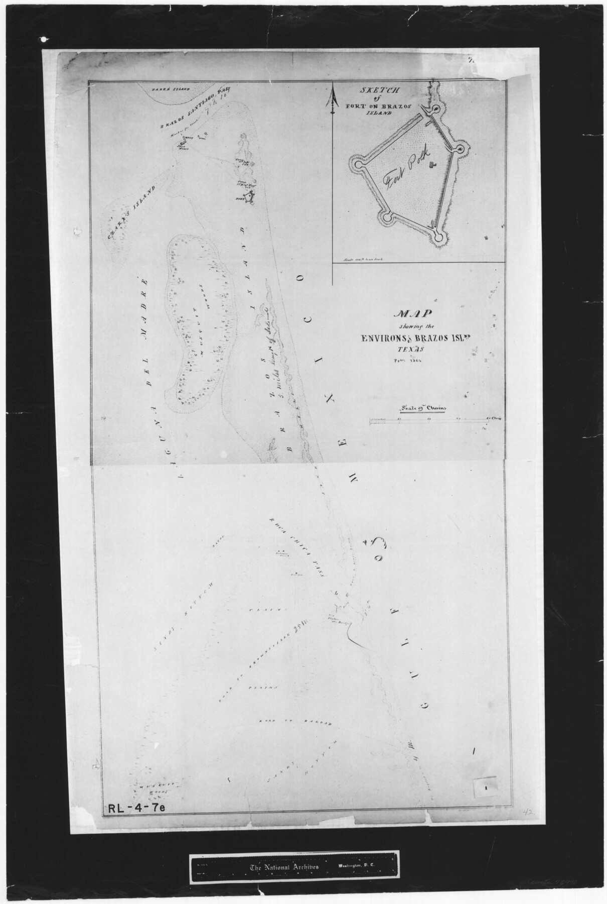
Map showing the environs of Brazos Islnd., Texas
RL-4-7e
-
Map/Doc
72990
-
Collection
General Map Collection
-
Object Dates
1864 (Creation Date)
-
Subjects
Gulf of Mexico Military
-
Height x Width
27.1 x 18.2 inches
68.8 x 46.2 cm
-
Comments
B/W photostat copy from National Archives.
Part of: General Map Collection
Presidio County Working Sketch 47

Print $20.00
- Digital $50.00
Presidio County Working Sketch 47
1950
Size 30.2 x 39.5 inches
Map/Doc 71724
Hutchinson County Sketch File 45

Print $22.00
- Digital $50.00
Hutchinson County Sketch File 45
1991
Size 11.1 x 8.8 inches
Map/Doc 27354
[Sketch of Col. Cooke's Military Road expedition from Red River to Austin]
![166, [Sketch of Col. Cooke's Military Road expedition from Red River to Austin], General Map Collection](https://historictexasmaps.com/wmedia_w700/maps/166.tif.jpg)
Print $20.00
- Digital $50.00
[Sketch of Col. Cooke's Military Road expedition from Red River to Austin]
Size 29.4 x 22.9 inches
Map/Doc 166
Freestone County Working Sketch 27

Print $20.00
- Digital $50.00
Freestone County Working Sketch 27
1986
Size 28.0 x 30.9 inches
Map/Doc 69269
Menard County Rolled Sketch 16

Print $20.00
- Digital $50.00
Menard County Rolled Sketch 16
1983
Size 29.8 x 36.6 inches
Map/Doc 6762
Northwest Part of Webb County

Print $40.00
- Digital $50.00
Northwest Part of Webb County
1984
Size 42.6 x 52.2 inches
Map/Doc 73319
Gray County Sketch File 10

Print $14.00
- Digital $50.00
Gray County Sketch File 10
Size 9.7 x 6.3 inches
Map/Doc 24445
Presidio County Rolled Sketch 53

Print $20.00
- Digital $50.00
Presidio County Rolled Sketch 53
1911
Size 23.9 x 18.2 inches
Map/Doc 7347
Nueces County Rolled Sketch 84

Print $20.00
- Digital $50.00
Nueces County Rolled Sketch 84
1982
Size 18.1 x 24.7 inches
Map/Doc 6970
Lipscomb County Boundary File 13

Print $4.00
- Digital $50.00
Lipscomb County Boundary File 13
Size 10.6 x 8.1 inches
Map/Doc 56353
McClennan County Robertson District East of the Brazos Milam District West of the Brazos

Print $20.00
- Digital $50.00
McClennan County Robertson District East of the Brazos Milam District West of the Brazos
1878
Size 21.0 x 23.4 inches
Map/Doc 3865
Val Verde County Sketch File A1

Print $6.00
- Digital $50.00
Val Verde County Sketch File A1
1895
Size 14.4 x 9.2 inches
Map/Doc 39038
You may also like
City of Austin, Texas - Use District Map

Print $20.00
- Digital $50.00
City of Austin, Texas - Use District Map
1943
Size 38.9 x 25.7 inches
Map/Doc 95705

Pecos County Working Sketch 28

Print $20.00
- Digital $50.00
Pecos County Working Sketch 28
1935
Size 27.9 x 29.2 inches
Map/Doc 71500
Flight Mission No. BRE-1P, Frame 50, Nueces County

Print $20.00
- Digital $50.00
Flight Mission No. BRE-1P, Frame 50, Nueces County
1956
Size 18.5 x 22.3 inches
Map/Doc 86639
Lampasas County Boundary File 16a

Print $28.00
- Digital $50.00
Lampasas County Boundary File 16a
Size 13.9 x 8.4 inches
Map/Doc 56223
Flight Mission No. DQO-1K, Frame 118, Galveston County

Print $20.00
- Digital $50.00
Flight Mission No. DQO-1K, Frame 118, Galveston County
1952
Size 18.9 x 22.6 inches
Map/Doc 84996
The Mexican Municipality of Mina. January 11, 1836

Print $20.00
The Mexican Municipality of Mina. January 11, 1836
2020
Size 10.7 x 21.7 inches
Map/Doc 96030
Polk County Sketch File 3

Print $10.00
- Digital $50.00
Polk County Sketch File 3
1848
Size 8.5 x 7.6 inches
Map/Doc 34122
Flight Mission No. DQO-12K, Frame 36, Galveston County

Print $20.00
- Digital $50.00
Flight Mission No. DQO-12K, Frame 36, Galveston County
1952
Size 18.8 x 22.6 inches
Map/Doc 85227
[Blocks M1 and 3T]
![93008, [Blocks M1 and 3T], Twichell Survey Records](https://historictexasmaps.com/wmedia_w700/maps/93008-1.tif.jpg)
Print $2.00
- Digital $50.00
[Blocks M1 and 3T]
Size 15.6 x 6.4 inches
Map/Doc 93008
Tyler County Sketch File 2

Print $4.00
- Digital $50.00
Tyler County Sketch File 2
Size 6.3 x 5.6 inches
Map/Doc 38615
Angelina County Sketch File 18

Print $4.00
- Digital $50.00
Angelina County Sketch File 18
Size 8.6 x 3.9 inches
Map/Doc 13028