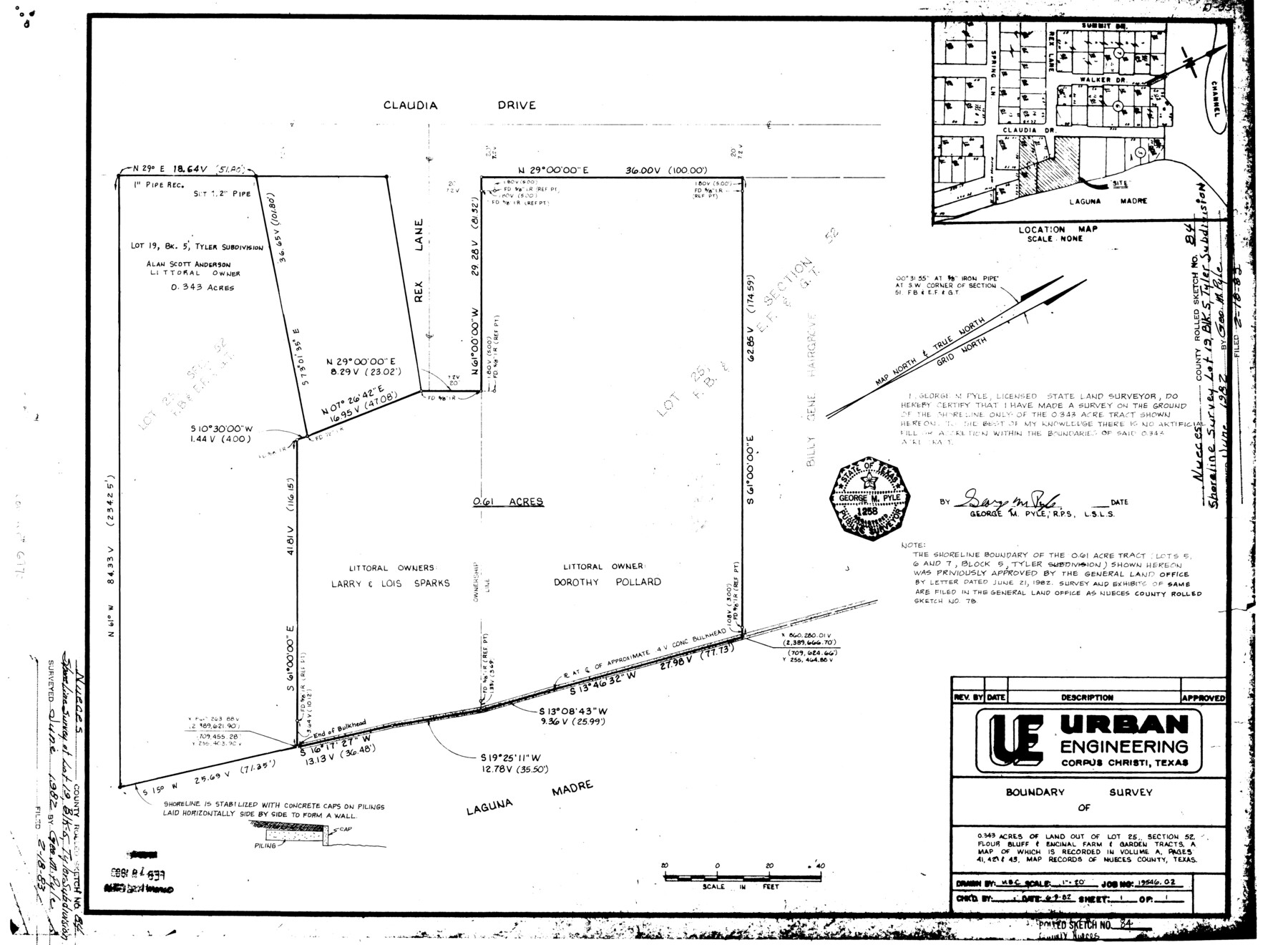
Nueces County Rolled Sketch 84
Boundary survey of 0.343 acres of land out of lot 25, section 52, Flour Bluff & Encinal Farm & Garden Tracts
-
Map/Doc
6970
-
Collection
General Map Collection
-
Object Dates
1982/6/9 (Creation Date)
1983/2/18 (File Date)
-
People and Organizations
George M. Pyle (Surveyor/Engineer)
-
Counties
Nueces
-
Subjects
Surveying Rolled Sketch
-
Height x Width
18.1 x 24.7 inches
46.0 x 62.7 cm
-
Medium
mylar, print
-
Scale
1" = 20 feet
Part of: General Map Collection
Liberty County Sketch File 25

Print $8.00
- Digital $50.00
Liberty County Sketch File 25
1861
Size 8.0 x 10.0 inches
Map/Doc 29939
Gillespie County Rolled Sketch 6

Print $20.00
- Digital $50.00
Gillespie County Rolled Sketch 6
2005
Size 18.2 x 24.6 inches
Map/Doc 83253
Denton County Sketch File 7

Print $8.00
- Digital $50.00
Denton County Sketch File 7
Size 13.7 x 7.9 inches
Map/Doc 20698
Gregg County Sketch File 1A

Print $6.00
- Digital $50.00
Gregg County Sketch File 1A
1847
Size 8.3 x 7.6 inches
Map/Doc 24535
Township 1 North Range 11 West, North Western District, Louisiana

Print $20.00
- Digital $50.00
Township 1 North Range 11 West, North Western District, Louisiana
1884
Size 19.6 x 24.7 inches
Map/Doc 65878
La Salle County Sketch File 51

Print $20.00
- Digital $50.00
La Salle County Sketch File 51
1984
Size 13.4 x 20.5 inches
Map/Doc 11990
San Patricio County Sketch File 24

Print $10.00
San Patricio County Sketch File 24
1918
Size 10.0 x 4.3 inches
Map/Doc 36078

Sherman County Working Sketch Graphic Index

Print $20.00
- Digital $50.00
Sherman County Working Sketch Graphic Index
1932
Size 41.5 x 36.9 inches
Map/Doc 76698
Brewster County Rolled Sketch 125

Print $179.00
- Digital $50.00
Brewster County Rolled Sketch 125
1889
Map/Doc 43141
Chambers County Rolled Sketch 23B

Print $20.00
- Digital $50.00
Chambers County Rolled Sketch 23B
1940
Size 40.9 x 40.8 inches
Map/Doc 8593
Map of the State of Texas Showing Original Land Districts

Print $20.00
- Digital $50.00
Map of the State of Texas Showing Original Land Districts
1891
Size 45.6 x 43.0 inches
Map/Doc 1995
You may also like
Flight Mission No. BQR-9K, Frame 43, Brazoria County

Print $20.00
- Digital $50.00
Flight Mission No. BQR-9K, Frame 43, Brazoria County
1952
Size 18.6 x 22.3 inches
Map/Doc 84047
Swisher County Sketch File 2a

Print $96.00
- Digital $50.00
Swisher County Sketch File 2a
1891
Size 14.3 x 8.7 inches
Map/Doc 37578
Val Verde County Sketch File 15 and 16

Print $60.00
- Digital $50.00
Val Verde County Sketch File 15 and 16
1883
Size 8.9 x 4.1 inches
Map/Doc 39207
Stonewall County

Print $40.00
- Digital $50.00
Stonewall County
1888
Size 56.1 x 55.2 inches
Map/Doc 89056
Engineer's Office, Department of the Gulf Map No. 59, Texas prepared by order of Maj. Gen. N. P. Banks under direction of Capt. P. C. Hains, U. S. Engr. & Chief Engr., Dept. of the Gulf

Print $20.00
- Digital $50.00
Engineer's Office, Department of the Gulf Map No. 59, Texas prepared by order of Maj. Gen. N. P. Banks under direction of Capt. P. C. Hains, U. S. Engr. & Chief Engr., Dept. of the Gulf
1865
Size 18.3 x 27.6 inches
Map/Doc 72717
Plat in Pecos County, Texas

Print $20.00
- Digital $50.00
Plat in Pecos County, Texas
Size 39.1 x 36.2 inches
Map/Doc 89830
Presidio County Sketch File 82

Print $22.00
- Digital $50.00
Presidio County Sketch File 82
1949
Size 14.3 x 8.8 inches
Map/Doc 34711
Navarro County Working Sketch 6

Print $20.00
- Digital $50.00
Navarro County Working Sketch 6
1950
Size 25.3 x 33.7 inches
Map/Doc 71236
Culberson County Working Sketch 18

Print $20.00
- Digital $50.00
Culberson County Working Sketch 18
1928
Size 42.6 x 19.7 inches
Map/Doc 68470
Calhoun County Rolled Sketch 29C

Print $20.00
- Digital $50.00
Calhoun County Rolled Sketch 29C
1977
Size 22.0 x 24.0 inches
Map/Doc 8559
Presidio County Rolled Sketch 131A

Print $3.00
- Digital $50.00
Presidio County Rolled Sketch 131A
Size 15.8 x 9.3 inches
Map/Doc 10708
Grayson County Working Sketch 13

Print $20.00
- Digital $50.00
Grayson County Working Sketch 13
1952
Size 31.1 x 38.0 inches
Map/Doc 63252