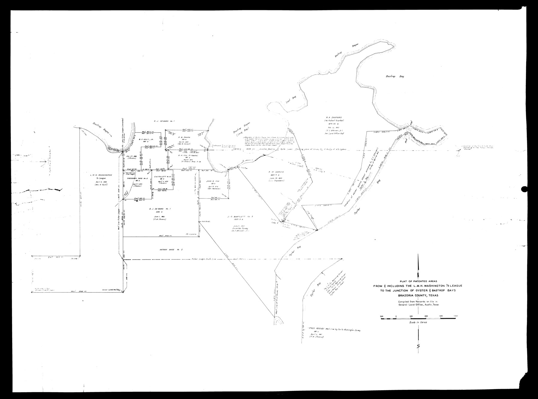
Brazoria County Rolled Sketch 36
Plat of patented areas from & including the L.M.H. Washington 1/3 League to the Junction of Oyster & Bastrop Bays
-
Map/Doc
5172
-
Collection
General Map Collection
-
Object Dates
1948/8/4 (File Date)
-
Counties
Brazoria
-
Subjects
Surveying Rolled Sketch
-
Height x Width
18.5 x 25.0 inches
47.0 x 63.5 cm
-
Medium
photostat
Part of: General Map Collection
Hansford County Sketch File 6

Print $8.00
- Digital $50.00
Hansford County Sketch File 6
1926
Size 13.6 x 9.0 inches
Map/Doc 24954
Hays County Boundary File 2

Print $40.00
- Digital $50.00
Hays County Boundary File 2
Size 6.9 x 26.1 inches
Map/Doc 54593
Hale County Rolled Sketch 10

Print $40.00
- Digital $50.00
Hale County Rolled Sketch 10
Size 52.8 x 56.6 inches
Map/Doc 9096
Fisher County Sketch File 19a

Print $42.00
- Digital $50.00
Fisher County Sketch File 19a
1898
Size 14.1 x 8.9 inches
Map/Doc 22595

Aransas County Rolled Sketch 24

Print $20.00
- Digital $50.00
Aransas County Rolled Sketch 24
Size 22.5 x 34.8 inches
Map/Doc 77495

Newton County Working Sketch 37

Print $20.00
- Digital $50.00
Newton County Working Sketch 37
1960
Size 31.7 x 22.7 inches
Map/Doc 71283
Val Verde County Sketch File Z18

Print $4.00
- Digital $50.00
Val Verde County Sketch File Z18
1910
Size 14.0 x 8.8 inches
Map/Doc 39148
Menard County Rolled Sketch 13

Print $20.00
- Digital $50.00
Menard County Rolled Sketch 13
1972
Size 30.8 x 24.0 inches
Map/Doc 6759
Jeff Davis County Sketch File 25b

Print $20.00
- Digital $50.00
Jeff Davis County Sketch File 25b
Size 18.9 x 20.0 inches
Map/Doc 11861
Right of Way and Track Map, Texas & New Orleans R.R. operated by the T. & N. O. R.R. Co., Rusk Branch

Print $40.00
- Digital $50.00
Right of Way and Track Map, Texas & New Orleans R.R. operated by the T. & N. O. R.R. Co., Rusk Branch
1918
Size 24.7 x 56.2 inches
Map/Doc 64243
You may also like
Flight Mission No. DQO-2K, Frame 141, Galveston County

Print $20.00
- Digital $50.00
Flight Mission No. DQO-2K, Frame 141, Galveston County
1952
Size 18.9 x 22.5 inches
Map/Doc 85038
Flight Mission No. DQN-1K, Frame 69, Calhoun County

Print $20.00
- Digital $50.00
Flight Mission No. DQN-1K, Frame 69, Calhoun County
1953
Size 18.5 x 22.2 inches
Map/Doc 84156
Medina County

Print $40.00
- Digital $50.00
Medina County
1915
Size 50.0 x 42.0 inches
Map/Doc 66925
[Pencil sketch showing triangulation from Flag on Mouth of Clear Fork and Top Hill]
![92088, [Pencil sketch showing triangulation from Flag on Mouth of Clear Fork and Top Hill], Twichell Survey Records](https://historictexasmaps.com/wmedia_w700/maps/92088-1.tif.jpg)
Print $20.00
- Digital $50.00
[Pencil sketch showing triangulation from Flag on Mouth of Clear Fork and Top Hill]
Size 19.5 x 12.5 inches
Map/Doc 92088
Zavala County Rolled Sketch 28

Print $20.00
- Digital $50.00
Zavala County Rolled Sketch 28
1956
Size 29.6 x 41.2 inches
Map/Doc 8330
Flight Mission No. BQY-4M, Frame 122, Harris County

Print $20.00
- Digital $50.00
Flight Mission No. BQY-4M, Frame 122, Harris County
1953
Size 18.6 x 22.4 inches
Map/Doc 85290
San Jacinto River and Tributaries, Texas - Survey of 1939

Print $20.00
- Digital $50.00
San Jacinto River and Tributaries, Texas - Survey of 1939
1939
Size 27.7 x 40.5 inches
Map/Doc 60310
Denkschrift Uber Eine Reise Nach Nord-Mexiko, Verbunden mit der Expedition des Obersten Doniphan, in den Jahren 1846 und 1847
Denkschrift Uber Eine Reise Nach Nord-Mexiko, Verbunden mit der Expedition des Obersten Doniphan, in den Jahren 1846 und 1847
1850
Map/Doc 97531
Sheet 3 copied from Champlin Book 5 [Strip Map showing T. & P. connecting lines]
![93179, Sheet 3 copied from Champlin Book 5 [Strip Map showing T. & P. connecting lines], Twichell Survey Records](https://historictexasmaps.com/wmedia_w700/maps/93179-1.tif.jpg)
Print $40.00
- Digital $50.00
Sheet 3 copied from Champlin Book 5 [Strip Map showing T. & P. connecting lines]
1909
Size 7.5 x 74.8 inches
Map/Doc 93179
Hockley County Sketch File 4

Print $6.00
- Digital $50.00
Hockley County Sketch File 4
Size 9.1 x 11.2 inches
Map/Doc 26536
The Principal Transportation Lines west of Chicago, St. Louis, & New Orleans, to accompany the report on the Internal Commerce of the United States for 1880

Print $20.00
- Digital $50.00
The Principal Transportation Lines west of Chicago, St. Louis, & New Orleans, to accompany the report on the Internal Commerce of the United States for 1880
1880
Size 26.7 x 22.7 inches
Map/Doc 95906
Rains County Working Sketch 6

Print $20.00
- Digital $50.00
Rains County Working Sketch 6
1958
Size 26.4 x 42.3 inches
Map/Doc 71832