Menard County Rolled Sketch 13
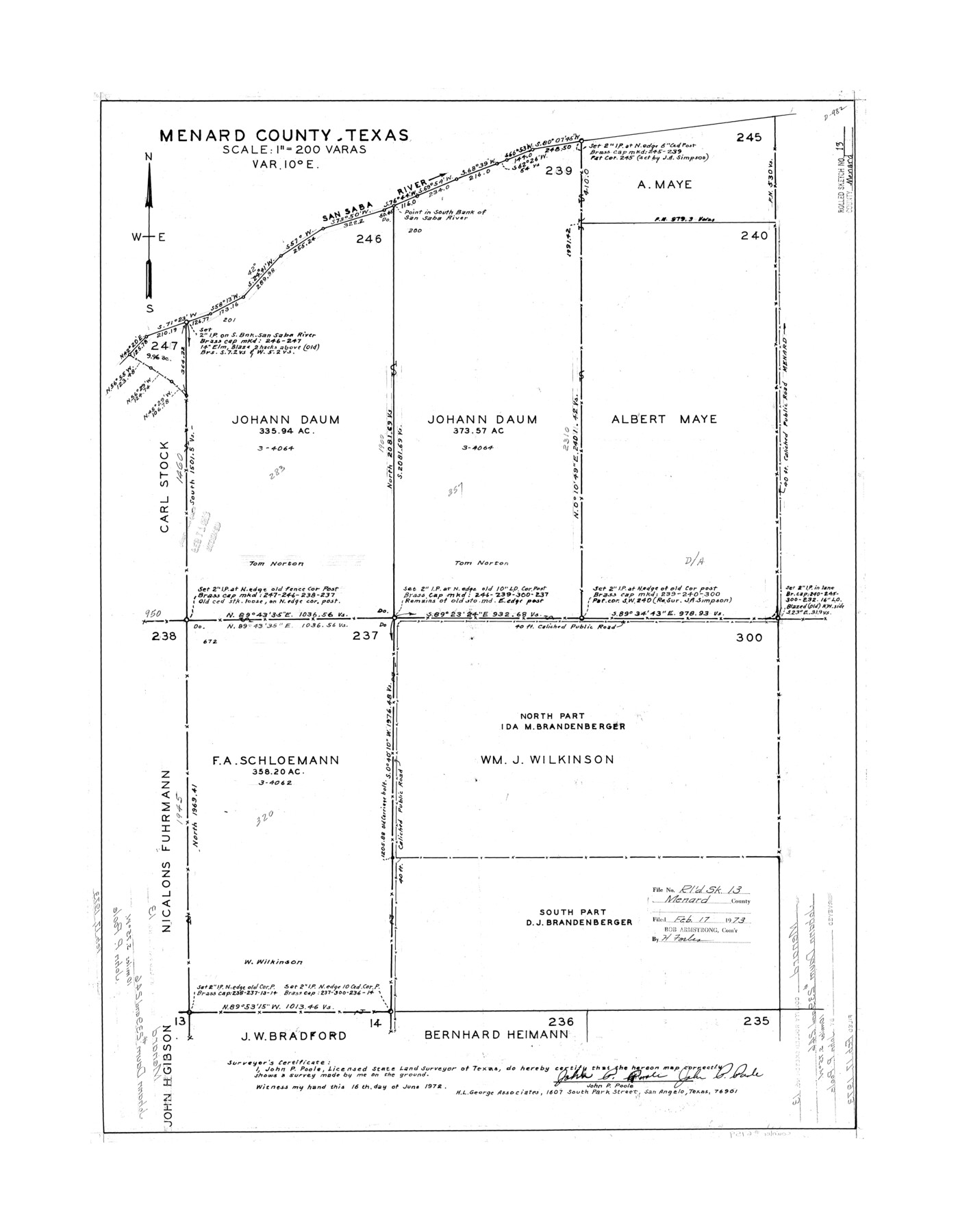
[Sketch of Johann Daum surveys 239 and 246 on San Saba River, Menard County, Texas]
-
Map/Doc
6759
-
Collection
General Map Collection
-
Object Dates
1972/6/16 (Creation Date)
1973/2/17 (File Date)
-
People and Organizations
John P. Poole (Surveyor/Engineer)
-
Counties
Menard
-
Subjects
Surveying Rolled Sketch
-
Height x Width
30.8 x 24.0 inches
78.2 x 61.0 cm
-
Scale
1" = 200 varas
Part of: General Map Collection
Polk County Working Sketch 39

Print $40.00
- Digital $50.00
Polk County Working Sketch 39
1978
Size 43.7 x 65.6 inches
Map/Doc 71656

Milam County Sketch File 2

Print $4.00
- Digital $50.00
Milam County Sketch File 2
1849
Size 8.0 x 12.4 inches
Map/Doc 31627
[T. & G. Ry. Main Line, Texas, Right of Way Map, Center to Gary]
![64568, [T. & G. Ry. Main Line, Texas, Right of Way Map, Center to Gary], General Map Collection](https://historictexasmaps.com/wmedia_w700/maps/64568-1.tif.jpg)
Print $40.00
- Digital $50.00
[T. & G. Ry. Main Line, Texas, Right of Way Map, Center to Gary]
1917
Size 31.0 x 121.2 inches
Map/Doc 64568
McCulloch County Working Sketch 10

Print $20.00
- Digital $50.00
McCulloch County Working Sketch 10
1979
Size 19.1 x 21.2 inches
Map/Doc 70685
Trinity County

Print $20.00
- Digital $50.00
Trinity County
1946
Size 40.5 x 40.7 inches
Map/Doc 77440
Flight Mission No. CRC-3R, Frame 163, Chambers County

Print $20.00
- Digital $50.00
Flight Mission No. CRC-3R, Frame 163, Chambers County
1956
Size 18.7 x 22.4 inches
Map/Doc 84845
Coke County Working Sketch 6

Print $20.00
- Digital $50.00
Coke County Working Sketch 6
1914
Size 19.1 x 15.7 inches
Map/Doc 68043
Flight Mission No. BRE-2P, Frame 13, Nueces County

Print $20.00
- Digital $50.00
Flight Mission No. BRE-2P, Frame 13, Nueces County
1956
Size 18.0 x 22.1 inches
Map/Doc 86722
Hemphill County

Print $20.00
- Digital $50.00
Hemphill County
1899
Size 42.2 x 34.1 inches
Map/Doc 4682
Edwards County Sketch File 24

Print $6.00
- Digital $50.00
Edwards County Sketch File 24
Size 8.9 x 13.2 inches
Map/Doc 21751
Presidio County Working Sketch 2

Print $20.00
- Digital $50.00
Presidio County Working Sketch 2
1907
Size 29.4 x 22.1 inches
Map/Doc 71676
You may also like
Geological Map of the route explored by Capt. Jno. Pope, Corps of Topl. Engrs. near the 32nd Parallel of North Latitude From the Red River to the Rio Grande

Print $20.00
- Digital $50.00
Geological Map of the route explored by Capt. Jno. Pope, Corps of Topl. Engrs. near the 32nd Parallel of North Latitude From the Red River to the Rio Grande
Size 11.5 x 24.7 inches
Map/Doc 95149
Flight Mission No. DCL-6C, Frame 128, Kenedy County

Print $20.00
- Digital $50.00
Flight Mission No. DCL-6C, Frame 128, Kenedy County
1943
Size 18.6 x 22.3 inches
Map/Doc 85958
[H. & G. N. Block 1]
![90941, [H. & G. N. Block 1], Twichell Survey Records](https://historictexasmaps.com/wmedia_w700/maps/90941-1.tif.jpg)
Print $20.00
- Digital $50.00
[H. & G. N. Block 1]
1873
Size 17.5 x 14.3 inches
Map/Doc 90941
San Jacinto River, Water Sheds of the San Jacinto River and Buffalo Bayou

Print $4.00
- Digital $50.00
San Jacinto River, Water Sheds of the San Jacinto River and Buffalo Bayou
Size 28.8 x 20.0 inches
Map/Doc 65149
Potter County Sketch File 10

Print $40.00
- Digital $50.00
Potter County Sketch File 10
Size 58.9 x 37.7 inches
Map/Doc 10576
Hardeman County Rolled Sketch 22

Print $20.00
- Digital $50.00
Hardeman County Rolled Sketch 22
Size 25.8 x 18.6 inches
Map/Doc 6073
[Plat showing 1.0 acre of land out of the NE/4 of Section 2, Block E]
![92706, [Plat showing 1.0 acre of land out of the NE/4 of Section 2, Block E], Twichell Survey Records](https://historictexasmaps.com/wmedia_w700/maps/92706-1.tif.jpg)
Print $3.00
- Digital $50.00
[Plat showing 1.0 acre of land out of the NE/4 of Section 2, Block E]
1954
Size 9.6 x 10.2 inches
Map/Doc 92706
Brewster County Rolled Sketch A

Print $40.00
- Digital $50.00
Brewster County Rolled Sketch A
Size 26.7 x 94.8 inches
Map/Doc 8925
[Leagues 464-467]
![91555, [Leagues 464-467], Twichell Survey Records](https://historictexasmaps.com/wmedia_w700/maps/91555-1.tif.jpg)
Print $20.00
- Digital $50.00
[Leagues 464-467]
Size 19.4 x 15.1 inches
Map/Doc 91555

Tom Green County Sketch File 63

Print $20.00
- Digital $50.00
Tom Green County Sketch File 63
1890
Size 31.8 x 17.9 inches
Map/Doc 12445
Pecos County Rolled Sketch 127

Print $20.00
- Digital $50.00
Pecos County Rolled Sketch 127
Size 20.7 x 23.9 inches
Map/Doc 7267