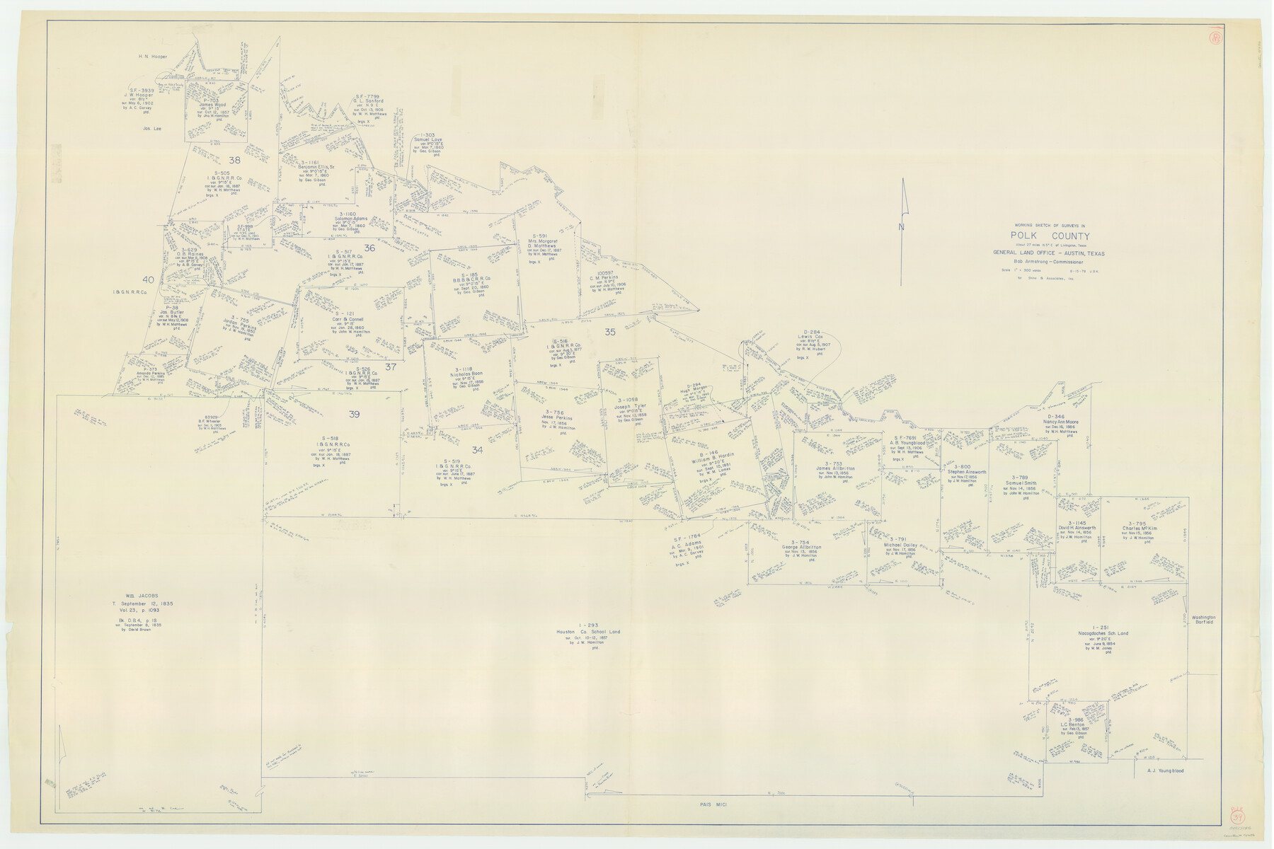
Polk County Working Sketch 39
-
Map/Doc
71656
-
Collection
General Map Collection
-
Object Dates
8/15/1978 (Creation Date)
-
People and Organizations
Joan Kilpatrick (Draftsman)
-
Counties
Polk
-
Subjects
Surveying Working Sketch
-
Height x Width
43.7 x 65.6 inches
111.0 x 166.6 cm
-
Scale
1" = 300 varas
Part of: General Map Collection
University Lands Hudspeth County, Texas, Blocks A to N

Print $40.00
- Digital $50.00
University Lands Hudspeth County, Texas, Blocks A to N
1935
Size 38.6 x 55.4 inches
Map/Doc 2447
Pecos County Rolled Sketch 44

Print $20.00
- Digital $50.00
Pecos County Rolled Sketch 44
1912
Size 22.9 x 37.6 inches
Map/Doc 7222
Map of Eastland Co.

Print $20.00
- Digital $50.00
Map of Eastland Co.
1896
Size 40.8 x 43.8 inches
Map/Doc 66809

Flight Mission No. CRC-2R, Frame 198, Chambers County

Print $20.00
- Digital $50.00
Flight Mission No. CRC-2R, Frame 198, Chambers County
1956
Size 18.7 x 22.4 inches
Map/Doc 84776
Floyd County Sketch File 14

Print $10.00
- Digital $50.00
Floyd County Sketch File 14
1913
Size 11.3 x 8.7 inches
Map/Doc 22731
San Saba County Working Sketch 11

Print $20.00
- Digital $50.00
San Saba County Working Sketch 11
1989
Size 30.3 x 38.2 inches
Map/Doc 63799
Dimmit County Working Sketch 8

Print $20.00
- Digital $50.00
Dimmit County Working Sketch 8
1930
Size 35.8 x 29.9 inches
Map/Doc 68669
Flight Mission No. CGI-4N, Frame 174, Cameron County

Print $20.00
- Digital $50.00
Flight Mission No. CGI-4N, Frame 174, Cameron County
1955
Size 18.7 x 22.3 inches
Map/Doc 84677
Dimmit County Working Sketch 40

Print $40.00
- Digital $50.00
Dimmit County Working Sketch 40
1968
Size 42.9 x 59.0 inches
Map/Doc 68701
Chambers County Sketch File 35

Print $14.00
- Digital $50.00
Chambers County Sketch File 35
Size 7.1 x 7.6 inches
Map/Doc 17625
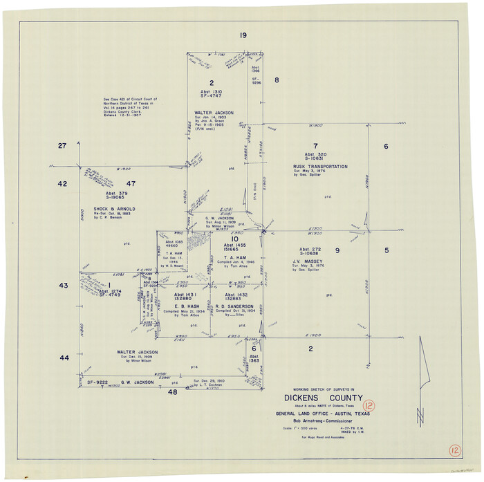
Dickens County Working Sketch 12
Print $20.00
- Digital $50.00
Dickens County Working Sketch 12
1978
Size 28.3 x 28.9 inches
Map/Doc 68660
You may also like
Crockett County Rolled Sketch 84

Print $20.00
- Digital $50.00
Crockett County Rolled Sketch 84
1961
Size 31.9 x 25.2 inches
Map/Doc 5624
Dallas County Working Sketch 6

Print $20.00
- Digital $50.00
Dallas County Working Sketch 6
1947
Size 16.7 x 25.9 inches
Map/Doc 68572
Angelina County Working Sketch 40

Print $20.00
- Digital $50.00
Angelina County Working Sketch 40
1960
Size 14.2 x 18.8 inches
Map/Doc 67123
Map of Bandera County

Print $40.00
- Digital $50.00
Map of Bandera County
1885
Size 33.5 x 64.7 inches
Map/Doc 4771
Bexar County Sketch File 56

Print $40.00
- Digital $50.00
Bexar County Sketch File 56
1966
Size 19.7 x 23.8 inches
Map/Doc 10927
Carte du Texas, Extraite de la grande Carte du Mexique par A. Brué Géographe du Roi, Revue, corrigée et considerablement augmentée d'après des documens récens et renseignemens fournis par Mr. le Docteur Fc. Leclerc

Print $20.00
- Digital $50.00
Carte du Texas, Extraite de la grande Carte du Mexique par A. Brué Géographe du Roi, Revue, corrigée et considerablement augmentée d'après des documens récens et renseignemens fournis par Mr. le Docteur Fc. Leclerc
1840
Size 12.6 x 14.2 inches
Map/Doc 94273
Parker County Sketch File 32

Print $6.00
- Digital $50.00
Parker County Sketch File 32
Size 11.0 x 12.2 inches
Map/Doc 33574
Topographical Map of the Rio Grande, Sheet No. 13

Print $20.00
- Digital $50.00
Topographical Map of the Rio Grande, Sheet No. 13
1912
Map/Doc 89537
Selected List of Wells accompanying Map of Wyoming showing Test Wells for Oil and Gas, Anticlinal Axes, Oil and Gas Fields, Pipelines, Unit Areas, and Land 3 District Boundaries, 1949

Print $20.00
- Digital $50.00
Selected List of Wells accompanying Map of Wyoming showing Test Wells for Oil and Gas, Anticlinal Axes, Oil and Gas Fields, Pipelines, Unit Areas, and Land 3 District Boundaries, 1949
1949
Size 26.2 x 41.5 inches
Map/Doc 89690
[Gulf Coast of Texas]
![72704, [Gulf Coast of Texas], General Map Collection](https://historictexasmaps.com/wmedia_w700/maps/72704.tif.jpg)
Print $20.00
- Digital $50.00
[Gulf Coast of Texas]
1881
Size 28.7 x 18.2 inches
Map/Doc 72704
[T. C. & S. F. Block K11, Capitol Leagues 367, 373, 374, and Blocks D and B]
![90536, [T. C. & S. F. Block K11, Capitol Leagues 367, 373, 374, and Blocks D and B], Twichell Survey Records](https://historictexasmaps.com/wmedia_w700/maps/90536-1.tif.jpg)
Print $3.00
- Digital $50.00
[T. C. & S. F. Block K11, Capitol Leagues 367, 373, 374, and Blocks D and B]
1903
Size 9.5 x 13.7 inches
Map/Doc 90536
No. 3 Chart of Channel connecting Corpus Christi Bay with Aransas Bay, Texas

Print $20.00
- Digital $50.00
No. 3 Chart of Channel connecting Corpus Christi Bay with Aransas Bay, Texas
1878
Size 18.4 x 28.0 inches
Map/Doc 72775