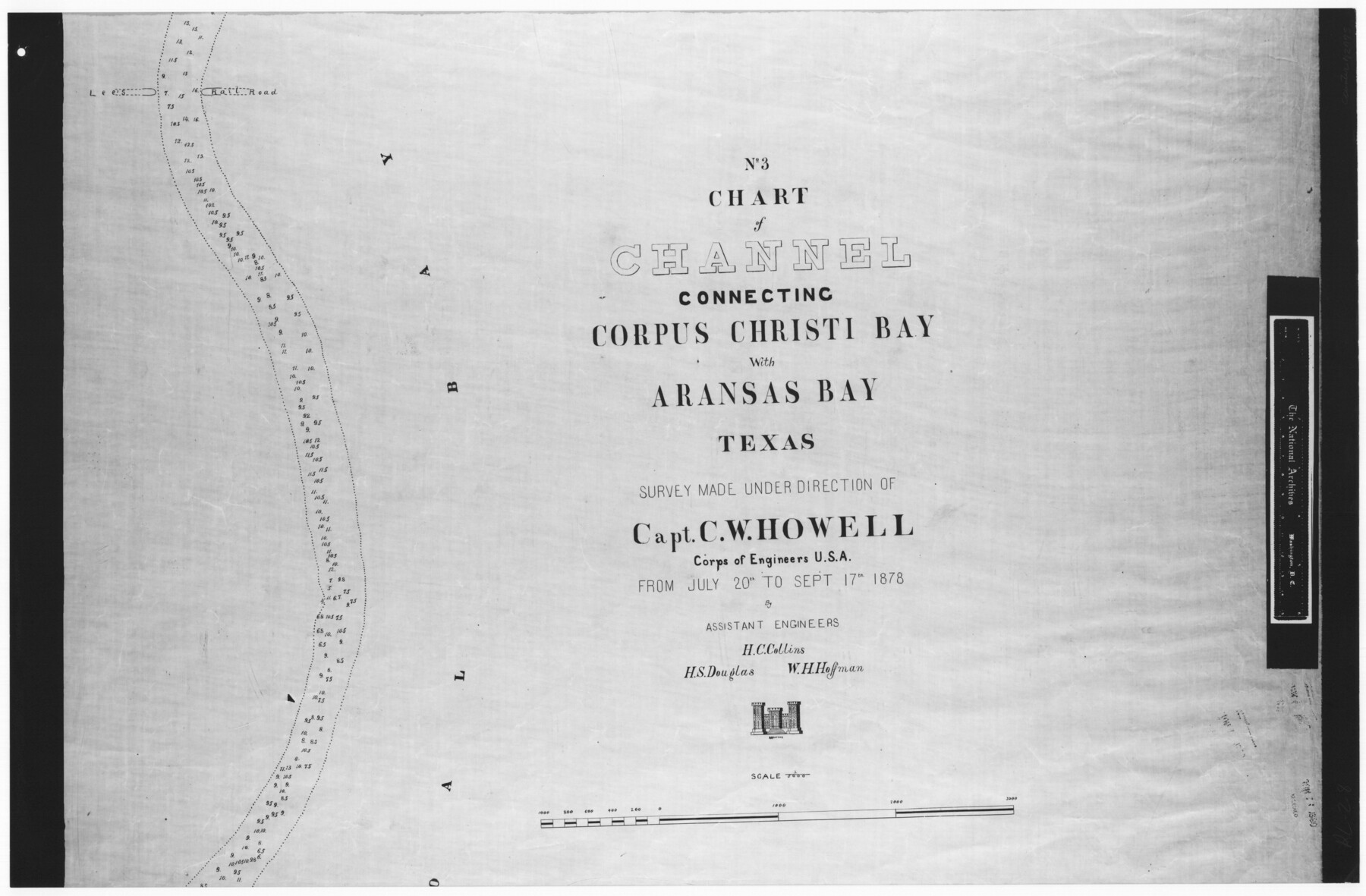
No. 3 Chart of Channel connecting Corpus Christi Bay with Aransas Bay, Texas
RL-2-8
-
Map/Doc
72775
-
Collection
General Map Collection
-
Object Dates
1878/9/17 (Creation Date)
-
People and Organizations
Corps of Engineers (Author)
W.H. Hoffman (Draftsman)
H.C. Collins (Draftsman)
H.S. Douglas (Draftsman)
-
Counties
Nueces
-
Subjects
Nautical Charts
-
Height x Width
18.4 x 28.0 inches
46.7 x 71.1 cm
-
Comments
B/W photostat copy from National Archives in multiple pieces.
Part of: General Map Collection
Jim Hogg County Working Sketch 6

Print $40.00
- Digital $50.00
Jim Hogg County Working Sketch 6
1961
Size 63.3 x 42.8 inches
Map/Doc 66592
Jackson County Sketch File 15

Print $13.00
- Digital $50.00
Jackson County Sketch File 15
Size 13.5 x 8.8 inches
Map/Doc 27662
Revised map of west half of Sabine Lake and Sabine Pass, showing subdivision for mineral development; Jefferson and Orange Counties

Print $40.00
- Digital $50.00
Revised map of west half of Sabine Lake and Sabine Pass, showing subdivision for mineral development; Jefferson and Orange Counties
1979
Size 72.1 x 41.5 inches
Map/Doc 1935
Atkinson's Casket Gems of Literature, Wit and Sentiment

Atkinson's Casket Gems of Literature, Wit and Sentiment
Size 9.2 x 6.1 inches
Map/Doc 95957
Hopkins County Sketch File 2a

Print $4.00
- Digital $50.00
Hopkins County Sketch File 2a
Size 13.6 x 8.6 inches
Map/Doc 26683
No. 2 Chart of Corpus Christi Pass, Texas

Print $20.00
- Digital $50.00
No. 2 Chart of Corpus Christi Pass, Texas
1878
Size 18.3 x 27.4 inches
Map/Doc 73022
Flight Mission No. DCL-6C, Frame 52, Kenedy County

Print $20.00
- Digital $50.00
Flight Mission No. DCL-6C, Frame 52, Kenedy County
1943
Size 18.6 x 22.4 inches
Map/Doc 85894
Map of Hale County

Print $20.00
- Digital $50.00
Map of Hale County
1900
Size 47.8 x 38.6 inches
Map/Doc 66847
Gregg County Working Sketch 11a

Print $20.00
- Digital $50.00
Gregg County Working Sketch 11a
1940
Size 26.2 x 32.9 inches
Map/Doc 63277
Concho County Sketch File 22

Print $20.00
- Digital $50.00
Concho County Sketch File 22
Size 24.9 x 18.1 inches
Map/Doc 11155
Map of Eastland Co.

Print $20.00
- Digital $50.00
Map of Eastland Co.
1896
Size 40.0 x 42.8 inches
Map/Doc 78411
Menard County Working Sketch 26

Print $20.00
- Digital $50.00
Menard County Working Sketch 26
1961
Size 28.6 x 36.1 inches
Map/Doc 70973
You may also like
General Highway Map, Freestone County, Texas

Print $20.00
General Highway Map, Freestone County, Texas
1961
Size 18.1 x 24.8 inches
Map/Doc 79472
Liberty County Sketch File 43

Print $4.00
- Digital $50.00
Liberty County Sketch File 43
1863
Size 13.6 x 8.5 inches
Map/Doc 30000
Rand, McNally & Co.'s Texas

Print $20.00
- Digital $50.00
Rand, McNally & Co.'s Texas
1893
Size 21.3 x 28.3 inches
Map/Doc 95842
Hutchinson County Working Sketch 3

Print $20.00
- Digital $50.00
Hutchinson County Working Sketch 3
Size 18.2 x 15.8 inches
Map/Doc 66361
Galveston County Working Sketch 10

Print $20.00
- Digital $50.00
Galveston County Working Sketch 10
Size 27.0 x 8.9 inches
Map/Doc 62190
Map of the Republic of Texas Shewing [sic] its division into Counties and Latest Improvements to 1837
![476, Map of the Republic of Texas Shewing [sic] its division into Counties and Latest Improvements to 1837, General Map Collection](https://historictexasmaps.com/wmedia_w700/maps/476-1.tif.jpg)
Print $20.00
- Digital $50.00
Map of the Republic of Texas Shewing [sic] its division into Counties and Latest Improvements to 1837
1837
Size 28.2 x 23.0 inches
Map/Doc 476
Zapata County Rolled Sketch 12B

Print $40.00
- Digital $50.00
Zapata County Rolled Sketch 12B
1917
Size 55.7 x 40.0 inches
Map/Doc 10166
Map of Val Verde County

Print $40.00
- Digital $50.00
Map of Val Verde County
1898
Size 80.7 x 42.7 inches
Map/Doc 16913
Map of Blanco County, Texas

Print $20.00
- Digital $50.00
Map of Blanco County, Texas
1880
Size 28.5 x 20.1 inches
Map/Doc 406
[Blanco County]
![3307, [Blanco County], General Map Collection](https://historictexasmaps.com/wmedia_w700/maps/3307-2.tif.jpg)
Print $20.00
- Digital $50.00
[Blanco County]
1872
Size 19.1 x 16.0 inches
Map/Doc 3307
Montague County Working Sketch 32

Print $20.00
- Digital $50.00
Montague County Working Sketch 32
1975
Size 26.0 x 26.1 inches
Map/Doc 71098
Starr County Sketch File 49

Print $20.00
- Digital $50.00
Starr County Sketch File 49
1951
Size 24.9 x 17.2 inches
Map/Doc 12346