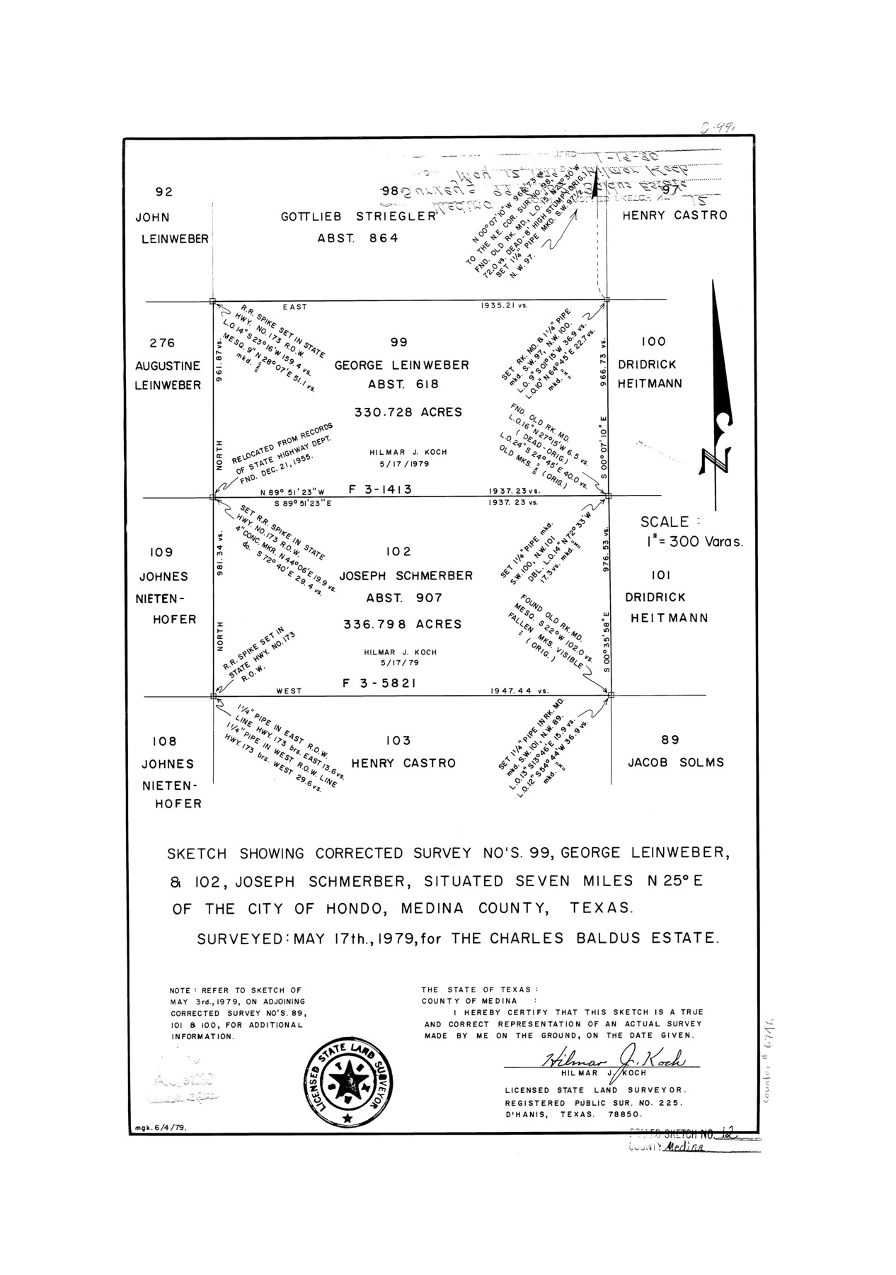
Medina County Rolled Sketch 12
Sketch showing corrected survey nos. 99, George Leinweber, & 102, Joseph Schmerber
-
Map/Doc
6746
-
Collection
General Map Collection
-
Object Dates
1979/6/4 (Creation Date)
1979/5/17 (Survey Date)
1980/1/19 (File Date)
-
People and Organizations
Hilmar J. Koch (Surveyor/Engineer)
-
Counties
Medina
-
Subjects
Surveying Rolled Sketch
-
Height x Width
20.9 x 14.7 inches
53.1 x 37.3 cm
-
Scale
1" = 300 varas
Part of: General Map Collection
DeWitt County Boundary File 3

Print $17.00
- Digital $50.00
DeWitt County Boundary File 3
Size 12.7 x 8.3 inches
Map/Doc 52514
Flight Mission No. DQO-1K, Frame 148, Galveston County

Print $20.00
- Digital $50.00
Flight Mission No. DQO-1K, Frame 148, Galveston County
1952
Size 18.8 x 22.5 inches
Map/Doc 85001
Van Zandt County Sketch File 7

Print $8.00
- Digital $50.00
Van Zandt County Sketch File 7
1849
Size 5.2 x 7.4 inches
Map/Doc 39375
Galveston County Rolled Sketch 37

Print $20.00
- Digital $50.00
Galveston County Rolled Sketch 37
Size 26.8 x 16.5 inches
Map/Doc 5971
Flight Mission No. CGI-3N, Frame 146, Cameron County

Print $20.00
- Digital $50.00
Flight Mission No. CGI-3N, Frame 146, Cameron County
1954
Size 18.5 x 22.1 inches
Map/Doc 84619
Webb County Sketch File 12-1

Print $16.00
- Digital $50.00
Webb County Sketch File 12-1
1886
Size 13.0 x 8.3 inches
Map/Doc 39793
Randall County Sketch File 2

Print $4.00
- Digital $50.00
Randall County Sketch File 2
1913
Size 7.3 x 8.8 inches
Map/Doc 34961
Flight Mission No. DIX-10P, Frame 83, Aransas County

Print $20.00
- Digital $50.00
Flight Mission No. DIX-10P, Frame 83, Aransas County
1956
Size 18.7 x 22.3 inches
Map/Doc 83944
McCulloch County Sketch File 9

Print $6.00
- Digital $50.00
McCulloch County Sketch File 9
1883
Size 7.3 x 8.7 inches
Map/Doc 31184
Webb County Rolled Sketch 44

Print $20.00
- Digital $50.00
Webb County Rolled Sketch 44
1941
Size 23.9 x 20.1 inches
Map/Doc 8199
Loving County Sketch File 9

Print $36.00
- Digital $50.00
Loving County Sketch File 9
2015
Size 14.0 x 8.5 inches
Map/Doc 93794
Val Verde County Sketch File XXX4

Print $4.00
- Digital $50.00
Val Verde County Sketch File XXX4
Size 12.8 x 8.4 inches
Map/Doc 39098
You may also like
Shelby County Working Sketch 1

Print $20.00
- Digital $50.00
Shelby County Working Sketch 1
1917
Size 26.2 x 30.0 inches
Map/Doc 63854
Howard County Sketch File 16

Print $40.00
- Digital $50.00
Howard County Sketch File 16
1947
Size 19.7 x 9.0 inches
Map/Doc 26878
Winkler County Working Sketch 11

Print $40.00
- Digital $50.00
Winkler County Working Sketch 11
1960
Size 28.5 x 81.4 inches
Map/Doc 72605
Flight Mission No. DAG-21K, Frame 30, Matagorda County

Print $20.00
- Digital $50.00
Flight Mission No. DAG-21K, Frame 30, Matagorda County
1952
Size 18.5 x 22.4 inches
Map/Doc 86397
Calhoun County Rolled Sketch 30

Print $20.00
- Digital $50.00
Calhoun County Rolled Sketch 30
1974
Size 18.5 x 27.5 inches
Map/Doc 5488
Map of Texas Gulf Coast and Texas Continental Shelf showing Natural Gas Pipe Lines

Print $40.00
- Digital $50.00
Map of Texas Gulf Coast and Texas Continental Shelf showing Natural Gas Pipe Lines
1968
Size 39.4 x 57.1 inches
Map/Doc 75903
Kimble County Sketch File 42

Print $10.00
- Digital $50.00
Kimble County Sketch File 42
1995
Size 11.2 x 8.8 inches
Map/Doc 29015
Cooke County Working Sketch 11

Print $20.00
- Digital $50.00
Cooke County Working Sketch 11
1940
Size 42.6 x 28.2 inches
Map/Doc 68248
Childress County Rolled Sketch 12

Print $20.00
- Digital $50.00
Childress County Rolled Sketch 12
1940
Size 44.2 x 11.3 inches
Map/Doc 8603
Map of that part of the boundary between the Republic of Texas and the United States, comprised between Logan's Ferry on the Sabine River and the 36th Mile Mound on the Meridian Line (Sheet No. 1)
![4671, Map of that part of the boundary between the Republic of Texas and the United States, comprised between Logan's Ferry on the Sabine River and the [3]6th Mile Mound on the [Meridian Line] (Sheet No. 1), General Map Collection](https://historictexasmaps.com/wmedia_w700/maps/4671-GC.tif.jpg)
Print $20.00
- Digital $50.00
Map of that part of the boundary between the Republic of Texas and the United States, comprised between Logan's Ferry on the Sabine River and the 36th Mile Mound on the Meridian Line (Sheet No. 1)
1842
Size 34.6 x 26.4 inches
Map/Doc 4671
Marion County Rolled Sketch 2

Print $40.00
- Digital $50.00
Marion County Rolled Sketch 2
1954
Size 82.7 x 43.2 inches
Map/Doc 76446
Menard County Sketch File 21

Print $40.00
- Digital $50.00
Menard County Sketch File 21
1913
Size 14.1 x 14.8 inches
Map/Doc 31551