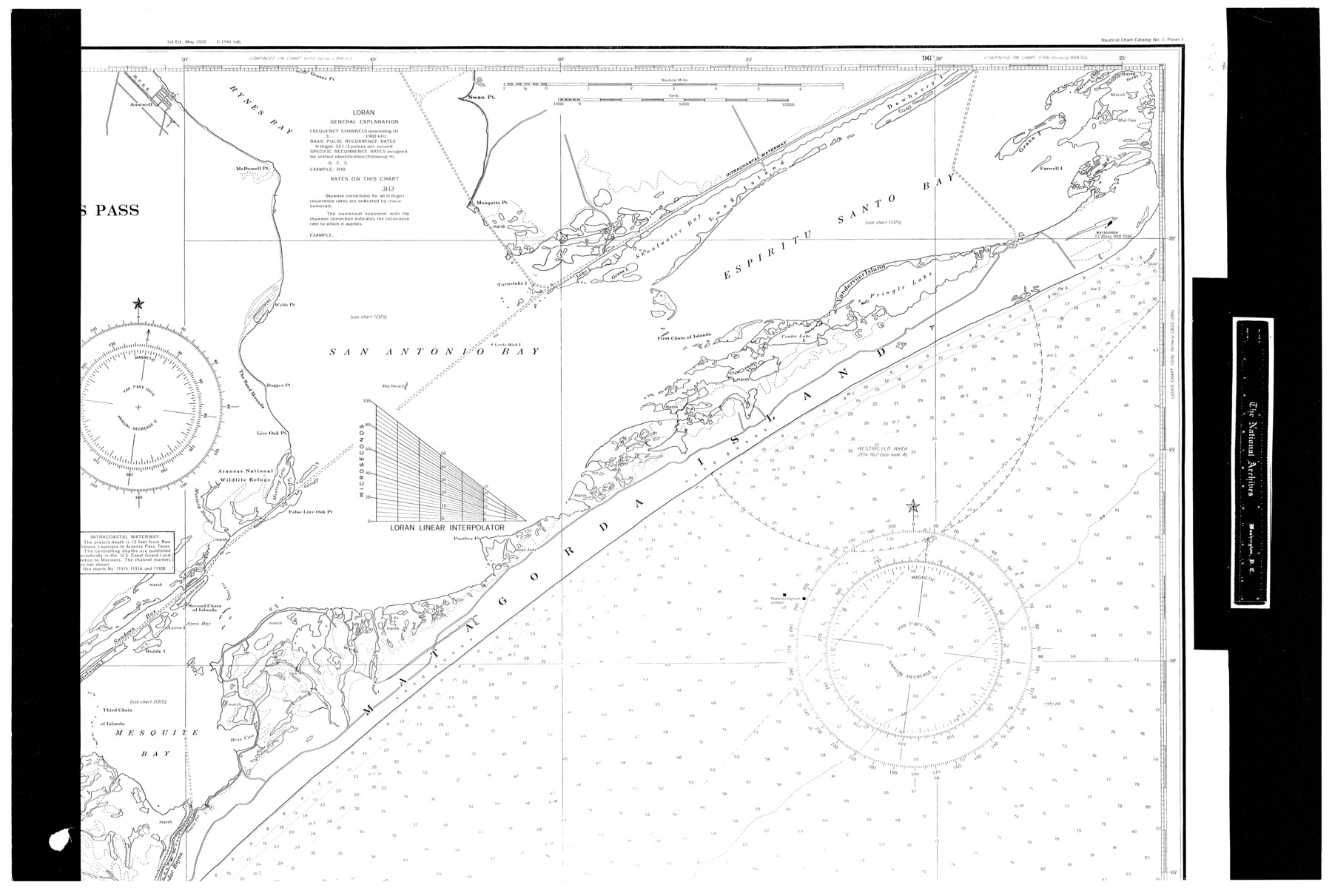
Calhoun County Rolled Sketch 30
Matagorda Light to Aransas Pass
-
Map/Doc
5488
-
Collection
General Map Collection
-
Object Dates
1974 (Creation Date)
1978/10/5 (File Date)
-
People and Organizations
U.S.C. and G.S. (Surveyor/Engineer)
-
Counties
Calhoun
-
Subjects
Surveying Rolled Sketch
-
Height x Width
18.5 x 27.5 inches
47.0 x 69.9 cm
Part of: General Map Collection
Duval County Working Sketch 30

Print $20.00
- Digital $50.00
Duval County Working Sketch 30
1950
Size 29.1 x 33.5 inches
Map/Doc 68754
Reagan County Working Sketch 30

Print $40.00
- Digital $50.00
Reagan County Working Sketch 30
1963
Size 31.9 x 57.3 inches
Map/Doc 71872
Presidio County Rolled Sketch 144

Print $20.00
- Digital $50.00
Presidio County Rolled Sketch 144
2010
Size 36.0 x 24.0 inches
Map/Doc 89603
San Jacinto County Sketch File 7

Print $10.00
- Digital $50.00
San Jacinto County Sketch File 7
1848
Size 8.1 x 10.0 inches
Map/Doc 35705
Cherokee County Working Sketch 14

Print $40.00
- Digital $50.00
Cherokee County Working Sketch 14
1957
Size 44.9 x 61.1 inches
Map/Doc 67969
Flight Mission No. BRA-16M, Frame 163, Jefferson County

Print $20.00
- Digital $50.00
Flight Mission No. BRA-16M, Frame 163, Jefferson County
1953
Size 18.6 x 22.3 inches
Map/Doc 85761
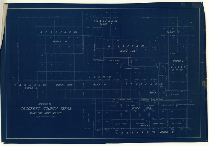
Crockett County Rolled Sketch 39
Print $20.00
- Digital $50.00
Crockett County Rolled Sketch 39
1935
Size 30.3 x 43.0 inches
Map/Doc 8705
Brazos County Rolled Sketch 6

Print $20.00
- Digital $50.00
Brazos County Rolled Sketch 6
1979
Size 24.3 x 36.4 inches
Map/Doc 5190
Brewster County Sketch File 55

Print $14.00
- Digital $50.00
Brewster County Sketch File 55
1999
Size 10.9 x 6.4 inches
Map/Doc 16385
Flight Mission No. DCL-7C, Frame 75, Kenedy County

Print $20.00
- Digital $50.00
Flight Mission No. DCL-7C, Frame 75, Kenedy County
1943
Size 15.3 x 15.2 inches
Map/Doc 86061
El Paso County State Real Property Sketch 2

Print $20.00
- Digital $50.00
El Paso County State Real Property Sketch 2
2007
Size 24.4 x 36.2 inches
Map/Doc 88671
Flight Mission No. DAG-22K, Frame 73, Matagorda County

Print $20.00
- Digital $50.00
Flight Mission No. DAG-22K, Frame 73, Matagorda County
1953
Size 18.7 x 22.4 inches
Map/Doc 86460
You may also like
Briscoe County Sketch File 5

Print $40.00
- Digital $50.00
Briscoe County Sketch File 5
Size 29.8 x 26.5 inches
Map/Doc 10994
Amistad International Reservoir on Rio Grande 68

Print $20.00
- Digital $50.00
Amistad International Reservoir on Rio Grande 68
1949
Size 28.4 x 39.4 inches
Map/Doc 73353
Karnes County Rolled Sketch 4

Print $20.00
- Digital $50.00
Karnes County Rolled Sketch 4
1961
Size 33.4 x 37.7 inches
Map/Doc 9667

Flight Mission No. DAG-26K, Frame 80, Matagorda County

Print $20.00
- Digital $50.00
Flight Mission No. DAG-26K, Frame 80, Matagorda County
1953
Size 18.5 x 22.3 inches
Map/Doc 86585
Stonewall County Working Sketch 21

Print $20.00
- Digital $50.00
Stonewall County Working Sketch 21
1961
Size 30.4 x 26.8 inches
Map/Doc 62328
Lubbock County Working Sketch 3

Print $20.00
- Digital $50.00
Lubbock County Working Sketch 3
1904
Size 13.9 x 20.5 inches
Map/Doc 70663
Bexar County Sketch File 21

Print $4.00
- Digital $50.00
Bexar County Sketch File 21
1859
Size 12.2 x 7.9 inches
Map/Doc 14484
Marion County Working Sketch 12

Print $20.00
- Digital $50.00
Marion County Working Sketch 12
1952
Size 24.5 x 34.2 inches
Map/Doc 70787

Johnson County Sketch File 10a

Print $4.00
- Digital $50.00
Johnson County Sketch File 10a
1877
Size 6.7 x 10.6 inches
Map/Doc 28445
Val Verde County Working Sketch 117

Print $20.00
- Digital $50.00
Val Verde County Working Sketch 117
1993
Size 33.8 x 37.0 inches
Map/Doc 82842