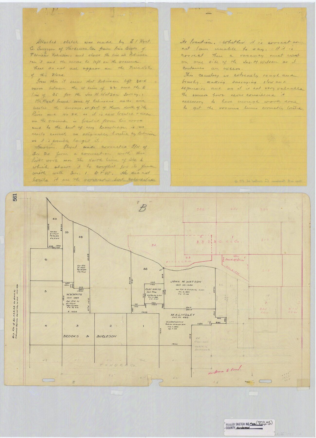
Hardeman County Rolled Sketch 22
[Sketch and field notes in SW part of the county]
-
Map/Doc
6073
-
Collection
General Map Collection
-
Object Dates
1938/5/31 (File Date)
-
People and Organizations
E.I. Hunt (Surveyor/Engineer)
-
Counties
Hardeman Foard
-
Subjects
Surveying Rolled Sketch
-
Height x Width
25.8 x 18.6 inches
65.5 x 47.2 cm
-
Medium
multi-page, multi-format
Part of: General Map Collection
Jim Hogg County Rolled Sketch EJ

Print $40.00
- Digital $50.00
Jim Hogg County Rolled Sketch EJ
1933
Size 50.7 x 37.0 inches
Map/Doc 9321
Ward County Working Sketch 43

Print $40.00
- Digital $50.00
Ward County Working Sketch 43
Size 57.3 x 36.8 inches
Map/Doc 72349
El Paso County Rolled Sketch 31

Print $20.00
- Digital $50.00
El Paso County Rolled Sketch 31
1908
Size 39.9 x 32.0 inches
Map/Doc 8858
The North Coast of the Gulf of Mexico from St. Marks to Galveston

Print $20.00
- Digital $50.00
The North Coast of the Gulf of Mexico from St. Marks to Galveston
1844
Size 27.5 x 41.1 inches
Map/Doc 97396
[Texas & Pacific Railway through Callahan County]
![64231, [Texas & Pacific Railway through Callahan County], General Map Collection](https://historictexasmaps.com/wmedia_w700/maps/64231.tif.jpg)
Print $20.00
- Digital $50.00
[Texas & Pacific Railway through Callahan County]
1918
Size 21.2 x 9.5 inches
Map/Doc 64231
Baylor County Sketch File 22

Print $10.00
- Digital $50.00
Baylor County Sketch File 22
1913
Size 11.2 x 8.8 inches
Map/Doc 14199
Jackson County

Print $20.00
- Digital $50.00
Jackson County
1920
Size 46.9 x 40.8 inches
Map/Doc 77324
King County Sketch File 2

Print $4.00
- Digital $50.00
King County Sketch File 2
1882
Size 13.2 x 9.2 inches
Map/Doc 29020
Galveston County NRC Article 33.136 Sketch 56

Print $42.00
- Digital $50.00
Galveston County NRC Article 33.136 Sketch 56
2009
Size 22.0 x 34.0 inches
Map/Doc 94733
Hutchinson County Sketch File 4a

Print $7.00
- Digital $50.00
Hutchinson County Sketch File 4a
Size 25.9 x 43.8 inches
Map/Doc 10625
Refugio County Working Sketch 13

Print $20.00
- Digital $50.00
Refugio County Working Sketch 13
1961
Size 23.8 x 29.8 inches
Map/Doc 63522
Map of Grimes County

Print $20.00
- Digital $50.00
Map of Grimes County
1881
Size 29.9 x 16.3 inches
Map/Doc 3606
You may also like
Reeves County Working Sketch 15

Print $40.00
- Digital $50.00
Reeves County Working Sketch 15
1961
Size 43.0 x 53.1 inches
Map/Doc 63458
Sutton County Sketch File F

Print $18.00
- Digital $50.00
Sutton County Sketch File F
1906
Size 14.1 x 8.7 inches
Map/Doc 37391
Minutes of the Ayuntamiento of San Felipe de Austin Vol. 2

Minutes of the Ayuntamiento of San Felipe de Austin Vol. 2
Size 13.3 x 10.5 inches
Map/Doc 94261
Harris County Working Sketch 3

Print $20.00
- Digital $50.00
Harris County Working Sketch 3
Size 14.7 x 22.4 inches
Map/Doc 65895
Andrews County Boundary File 5

Print $40.00
- Digital $50.00
Andrews County Boundary File 5
Size 29.8 x 19.6 inches
Map/Doc 49723
Calhoun County Rolled Sketch 14

Print $20.00
- Digital $50.00
Calhoun County Rolled Sketch 14
Size 22.2 x 40.7 inches
Map/Doc 5455
General Highway Map. Detail of Cities and Towns in Lubbock County, Texas [Lubbock and vicinity]
![79181, General Highway Map. Detail of Cities and Towns in Lubbock County, Texas [Lubbock and vicinity], Texas State Library and Archives](https://historictexasmaps.com/wmedia_w700/maps/79181.tif.jpg)
Print $20.00
General Highway Map. Detail of Cities and Towns in Lubbock County, Texas [Lubbock and vicinity]
1940
Size 18.3 x 24.8 inches
Map/Doc 79181
Gregg County Boundary File 8

Print $8.00
- Digital $50.00
Gregg County Boundary File 8
Size 14.0 x 8.6 inches
Map/Doc 54019
Robertson County Sketch File 4

Print $12.00
Robertson County Sketch File 4
1862
Size 11.0 x 8.0 inches
Map/Doc 35352
Crockett County Rolled Sketch 46C

Print $20.00
- Digital $50.00
Crockett County Rolled Sketch 46C
Size 24.5 x 23.8 inches
Map/Doc 5595
Rusk County Sketch File 19a

Print $4.00
Rusk County Sketch File 19a
1860
Size 8.2 x 6.6 inches
Map/Doc 35528
[Panhandle Counties]
![89951, [Panhandle Counties], Twichell Survey Records](https://historictexasmaps.com/wmedia_w700/maps/89951-1.tif.jpg)
Print $20.00
- Digital $50.00
[Panhandle Counties]
Size 41.8 x 43.2 inches
Map/Doc 89951