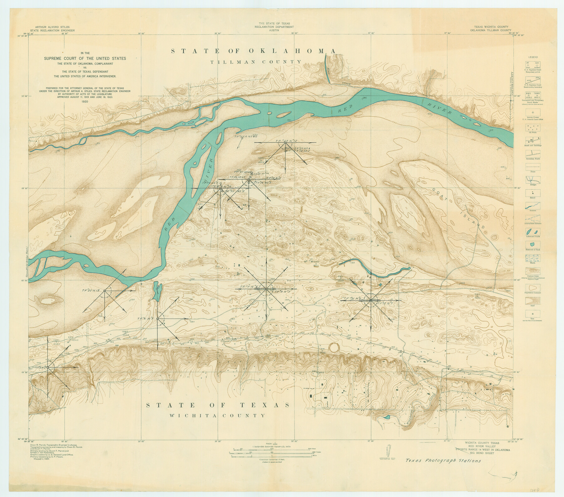
Big Bend Sheet
-
Map/Doc
79760
-
Collection
Texas State Library and Archives
-
Object Dates
1920 (Creation Date)
-
People and Organizations
State Reclamation Department (Publisher)
Dixon B. Penick (Surveyor/Engineer)
Stuart T. Penick (Surveyor/Engineer)
-
Counties
Wichita
-
Subjects
Texas Boundaries Topographic
-
Height x Width
32.8 x 37.2 inches
83.3 x 94.5 cm
-
Comments
Prints available courtesy of the Texas State Library and Archives.
More info can be found here: TSLAC Map 02972
Part of: Texas State Library and Archives
General Highway Map, Childress County, Texas

Print $20.00
General Highway Map, Childress County, Texas
1940
Size 18.3 x 25.2 inches
Map/Doc 79046
General Highway Map, Tom Green County, Texas

Print $20.00
General Highway Map, Tom Green County, Texas
1961
Size 25.0 x 18.1 inches
Map/Doc 79677
Topographic Map of Big Bend Area

Print $40.00
Topographic Map of Big Bend Area
1923
Size 59.0 x 35.4 inches
Map/Doc 79756
Oil and Gas Fields in the State of Texas

Print $40.00
Oil and Gas Fields in the State of Texas
1927
Size 58.0 x 38.0 inches
Map/Doc 76304
General Highway Map, Tom Green County, Texas

Print $20.00
General Highway Map, Tom Green County, Texas
1940
Size 25.0 x 18.5 inches
Map/Doc 79260
Map of the Country Adjacent to the Left Bank of the Rio Grande below Matamoros

Print $20.00
Map of the Country Adjacent to the Left Bank of the Rio Grande below Matamoros
1847
Size 27.8 x 22.8 inches
Map/Doc 79731
General Highway Map, Detail of Cities and Towns in Delta County, Hopkins County [Cooper and vicinity]
![79440, General Highway Map, Detail of Cities and Towns in Delta County, Hopkins County [Cooper and vicinity], Texas State Library and Archives](https://historictexasmaps.com/wmedia_w700/maps/79440.tif.jpg)
Print $20.00
General Highway Map, Detail of Cities and Towns in Delta County, Hopkins County [Cooper and vicinity]
1961
Size 18.2 x 24.4 inches
Map/Doc 79440
General Highway Map. Detail of Cities and Towns in Kinney County, Uvalde County [Uvalde and vicinity]
![79557, General Highway Map. Detail of Cities and Towns in Kinney County, Uvalde County [Uvalde and vicinity], Texas State Library and Archives](https://historictexasmaps.com/wmedia_w700/maps/79557.tif.jpg)
Print $20.00
General Highway Map. Detail of Cities and Towns in Kinney County, Uvalde County [Uvalde and vicinity]
1961
Size 18.2 x 24.6 inches
Map/Doc 79557
General Highway Map, Live Oak County, Texas

Print $20.00
General Highway Map, Live Oak County, Texas
1940
Size 18.5 x 24.8 inches
Map/Doc 79176
General Highway Map, Williamson County, Texas

Print $20.00
General Highway Map, Williamson County, Texas
1940
Size 24.7 x 18.4 inches
Map/Doc 79281
General Highway Map, Oldham County, Deaf Smith County, Texas

Print $20.00
General Highway Map, Oldham County, Deaf Smith County, Texas
1940
Size 18.3 x 25.2 inches
Map/Doc 79072
General Highway Map, Hidalgo County, Texas

Print $20.00
General Highway Map, Hidalgo County, Texas
1961
Size 18.2 x 24.8 inches
Map/Doc 79519
You may also like
![90260, [League 271], Twichell Survey Records](https://historictexasmaps.com/wmedia_w700/maps/90260-1.tif.jpg)
Ward County Working Sketch 43

Print $40.00
- Digital $50.00
Ward County Working Sketch 43
Size 57.3 x 36.8 inches
Map/Doc 72349
Montague County

Print $20.00
- Digital $50.00
Montague County
1924
Size 46.4 x 33.7 inches
Map/Doc 77376

Township No. 1 South Range No. 20 West of the Indian Meridian

Print $20.00
- Digital $50.00
Township No. 1 South Range No. 20 West of the Indian Meridian
1875
Size 19.3 x 24.4 inches
Map/Doc 75179

Kendall County Boundary File 2a

Print $12.00
- Digital $50.00
Kendall County Boundary File 2a
Size 10.0 x 7.9 inches
Map/Doc 55748
Wharton County Working Sketch 16

Print $20.00
- Digital $50.00
Wharton County Working Sketch 16
1952
Size 23.8 x 26.8 inches
Map/Doc 72480
Louisiana and Texas Intracoastal Waterway Proposed Extension to Rio Grande Valley

Print $20.00
- Digital $50.00
Louisiana and Texas Intracoastal Waterway Proposed Extension to Rio Grande Valley
1941
Size 28.1 x 41.1 inches
Map/Doc 61891
Land of the Maya, a Traveler's Map

Land of the Maya, a Traveler's Map
Size 27.2 x 20.5 inches
Map/Doc 95933
[Aaron Cherry, Augustin M. de Lejarza, & Surrounding Surveys]
![91078, [Aaron Cherry, Augustin M. de Lejarza, & Surrounding Surveys], Twichell Survey Records](https://historictexasmaps.com/wmedia_w700/maps/91078-1.tif.jpg)
Print $20.00
- Digital $50.00
[Aaron Cherry, Augustin M. de Lejarza, & Surrounding Surveys]
Size 26.3 x 16.4 inches
Map/Doc 91078
Map of Henderson County

Print $20.00
- Digital $50.00
Map of Henderson County
1877
Size 17.7 x 29.2 inches
Map/Doc 3666