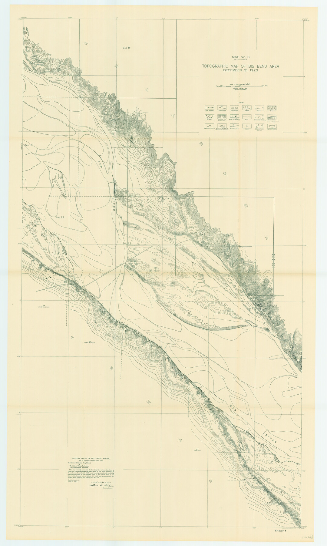
Topographic Map of Big Bend Area
-
Map/Doc
79756
-
Collection
Texas State Library and Archives
-
Object Dates
12/31/1923 (Creation Date)
-
People and Organizations
U.S. Geological Survey (Publisher)
U.S. Geological Survey (Printer)
-
Subjects
Texas Boundaries Topographic
-
Height x Width
59.0 x 35.4 inches
149.9 x 89.9 cm
-
Comments
Prints available courtesy of the Texas State Library and Archives.
More info can be found here: TSLAC Map 03116
Part of: Texas State Library and Archives
General Highway Map, Matagorda County, Texas

Print $20.00
General Highway Map, Matagorda County, Texas
1939
Size 24.7 x 18.3 inches
Map/Doc 79187
General Highway Map. Detail of Cities and Towns in Angelina County, Texas [Lufkin and vicinity]
![79351, General Highway Map. Detail of Cities and Towns in Angelina County, Texas [Lufkin and vicinity], Texas State Library and Archives](https://historictexasmaps.com/wmedia_w700/maps/79351.tif.jpg)
Print $20.00
General Highway Map. Detail of Cities and Towns in Angelina County, Texas [Lufkin and vicinity]
1961
Size 18.3 x 25.0 inches
Map/Doc 79351
General Highway Map. Detail of Cities and Towns in Bowie County, Texas

Print $20.00
General Highway Map. Detail of Cities and Towns in Bowie County, Texas
1961
Size 18.0 x 24.8 inches
Map/Doc 79381
General Highway Map, Schleicher County, Sutton County, Texas

Print $20.00
General Highway Map, Schleicher County, Sutton County, Texas
1961
Size 18.2 x 24.3 inches
Map/Doc 79649
General Highway Map, Austin County, Texas

Print $20.00
General Highway Map, Austin County, Texas
1961
Size 18.1 x 25.1 inches
Map/Doc 79357
General Highway Map, Grayson County, Texas

Print $20.00
General Highway Map, Grayson County, Texas
1961
Size 24.6 x 18.1 inches
Map/Doc 79485
General Highway Map, Lynn County, Texas

Print $20.00
General Highway Map, Lynn County, Texas
1940
Size 18.2 x 24.9 inches
Map/Doc 79182
General Highway Map, Franklin County, Texas

Print $20.00
General Highway Map, Franklin County, Texas
1961
Size 18.1 x 24.5 inches
Map/Doc 79471
General Highway Map, Cochran County, Texas

Print $20.00
General Highway Map, Cochran County, Texas
1940
Size 25.2 x 18.5 inches
Map/Doc 79048
General Highway Map, Ector County, Texas

Print $20.00
General Highway Map, Ector County, Texas
1961
Size 18.0 x 24.8 inches
Map/Doc 79451
General Highway Map, Hutchinson County, Texas

Print $20.00
General Highway Map, Hutchinson County, Texas
1961
Size 18.1 x 24.6 inches
Map/Doc 79529
General Highway Map, Reeves County, Texas

Print $20.00
General Highway Map, Reeves County, Texas
1961
Size 24.6 x 18.2 inches
Map/Doc 79638
You may also like
Flight Mission No. BQR-3K, Frame 151, Brazoria County

Print $20.00
- Digital $50.00
Flight Mission No. BQR-3K, Frame 151, Brazoria County
1952
Size 18.7 x 22.4 inches
Map/Doc 83978
Edwards County Working Sketch 3

Print $20.00
- Digital $50.00
Edwards County Working Sketch 3
Size 22.6 x 18.3 inches
Map/Doc 68879
Flight Mission No. DIX-10P, Frame 78, Aransas County

Print $20.00
- Digital $50.00
Flight Mission No. DIX-10P, Frame 78, Aransas County
1956
Size 18.8 x 22.4 inches
Map/Doc 83939

Montgomery County Working Sketch 76

Print $20.00
- Digital $50.00
Montgomery County Working Sketch 76
Size 16.5 x 18.3 inches
Map/Doc 78191
Williamson County Working Sketch 13

Print $20.00
- Digital $50.00
Williamson County Working Sketch 13
1980
Size 26.6 x 43.5 inches
Map/Doc 72573
Travis County

Print $40.00
- Digital $50.00
Travis County
1963
Size 37.7 x 50.7 inches
Map/Doc 73597
Flight Mission No. BRE-1P, Frame 105, Nueces County

Print $20.00
- Digital $50.00
Flight Mission No. BRE-1P, Frame 105, Nueces County
1956
Size 18.4 x 22.2 inches
Map/Doc 86676
Brewster County Working Sketch 60

Print $20.00
- Digital $50.00
Brewster County Working Sketch 60
1955
Size 22.3 x 18.2 inches
Map/Doc 67661
Castro County Sketch File 4e

Print $4.00
- Digital $50.00
Castro County Sketch File 4e
Size 13.6 x 8.9 inches
Map/Doc 17473
Montgomery County Working Sketch 31

Print $20.00
- Digital $50.00
Montgomery County Working Sketch 31
Size 24.7 x 18.7 inches
Map/Doc 71138
General Highway Map, Live Oak County, Texas

Print $20.00
General Highway Map, Live Oak County, Texas
1961
Size 18.2 x 24.8 inches
Map/Doc 79574