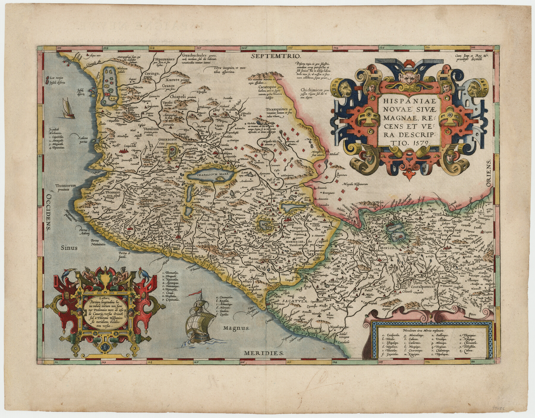
Hispaniae Novae Sivae Magnae Recens et Vera Descriptio 1579
-
Map/Doc
94036
-
Collection
General Map Collection
-
Object Dates
1581 (Creation Date)
-
People and Organizations
[Abraham Ortelius] (Cartographer)
-
Subjects
Atlas Mexico
-
Height x Width
17.9 x 23.0 inches
45.5 x 58.4 cm
-
Medium
paper, etching/engraving/lithograph
-
Comments
From Ortelius' Theatrum Orbis Terrarum atlas. To view/download the text on verso, please click the "Download PDF" link above.
Part of: General Map Collection
Burnet County Rolled Sketch 5

Print $40.00
- Digital $50.00
Burnet County Rolled Sketch 5
1971
Size 36.5 x 49.6 inches
Map/Doc 8542
Upton County Rolled Sketch 58

Print $20.00
- Digital $50.00
Upton County Rolled Sketch 58
Size 39.0 x 35.0 inches
Map/Doc 46125
Brewster County Sketch File 44

Print $3.00
- Digital $50.00
Brewster County Sketch File 44
Size 11.5 x 9.4 inches
Map/Doc 16311
Wharton County Rolled Sketch 11

Print $20.00
- Digital $50.00
Wharton County Rolled Sketch 11
Size 27.7 x 37.1 inches
Map/Doc 8236
Right of Way & Track Map San Antonio & Aransas Pass Railway Co.

Print $40.00
- Digital $50.00
Right of Way & Track Map San Antonio & Aransas Pass Railway Co.
1919
Size 25.2 x 56.7 inches
Map/Doc 64040
Parker County Working Sketch 21

Print $20.00
- Digital $50.00
Parker County Working Sketch 21
2006
Map/Doc 83655
Gillespie County Sketch File 14

Print $6.00
- Digital $50.00
Gillespie County Sketch File 14
1880
Size 10.1 x 11.4 inches
Map/Doc 24155
Colorado County Sketch File 15

Print $4.00
- Digital $50.00
Colorado County Sketch File 15
Size 13.0 x 8.1 inches
Map/Doc 18943
Eastland County Working Sketch 29

Print $20.00
- Digital $50.00
Eastland County Working Sketch 29
1952
Size 21.1 x 22.3 inches
Map/Doc 68810
Angelina County Sketch File 12

Print $4.00
- Digital $50.00
Angelina County Sketch File 12
1860
Size 14.1 x 8.1 inches
Map/Doc 12955
Starr County Sketch File 10

Print $40.00
- Digital $50.00
Starr County Sketch File 10
Size 12.6 x 15.0 inches
Map/Doc 36863
Liberty County Sketch File 61

Print $12.00
- Digital $50.00
Liberty County Sketch File 61
1950
Size 14.2 x 8.8 inches
Map/Doc 30077
You may also like
La Salle County Working Sketch 15

Print $20.00
- Digital $50.00
La Salle County Working Sketch 15
1935
Size 27.4 x 17.2 inches
Map/Doc 70316
Sutton County Working Sketch 12

Print $40.00
- Digital $50.00
Sutton County Working Sketch 12
1972
Size 66.8 x 37.3 inches
Map/Doc 62355
Sketch of a portion of the Texas Coast showing the relative positions of different harbours with the interior Military Posts, and the roads communicating with them, also two new routes from Black Point and Lamar to San Antonio

Print $20.00
- Digital $50.00
Sketch of a portion of the Texas Coast showing the relative positions of different harbours with the interior Military Posts, and the roads communicating with them, also two new routes from Black Point and Lamar to San Antonio
1855
Size 27.5 x 18.2 inches
Map/Doc 72708
Harris County Working Sketch 110

Print $20.00
- Digital $50.00
Harris County Working Sketch 110
1982
Size 21.3 x 22.0 inches
Map/Doc 66002
Map of South Brady Ranch, Concho County, Texas

Print $3.00
- Digital $50.00
Map of South Brady Ranch, Concho County, Texas
1880
Size 12.9 x 10.5 inches
Map/Doc 424
Schleicher County Sketch File 23a

Print $4.00
- Digital $50.00
Schleicher County Sketch File 23a
1937
Size 11.3 x 8.8 inches
Map/Doc 36514
[Jose Ostane survey]
![89983, [Jose Ostane survey], Twichell Survey Records](https://historictexasmaps.com/wmedia_w700/maps/89983-1.tif.jpg)
Print $3.00
- Digital $50.00
[Jose Ostane survey]
Size 14.6 x 9.3 inches
Map/Doc 89983
Young County Rolled Sketch 12

Print $20.00
- Digital $50.00
Young County Rolled Sketch 12
Size 24.2 x 17.9 inches
Map/Doc 8300
Webb County Working Sketch 48

Print $20.00
- Digital $50.00
Webb County Working Sketch 48
1948
Size 28.5 x 41.4 inches
Map/Doc 72413
Jefferson County Sketch File 18

Print $40.00
- Digital $50.00
Jefferson County Sketch File 18
Size 15.7 x 14.0 inches
Map/Doc 28167
Concho County Working Sketch 23

Print $20.00
- Digital $50.00
Concho County Working Sketch 23
1975
Size 21.9 x 27.1 inches
Map/Doc 68205
Houston County Working Sketch 13

Print $20.00
- Digital $50.00
Houston County Working Sketch 13
1956
Size 39.3 x 39.6 inches
Map/Doc 66243