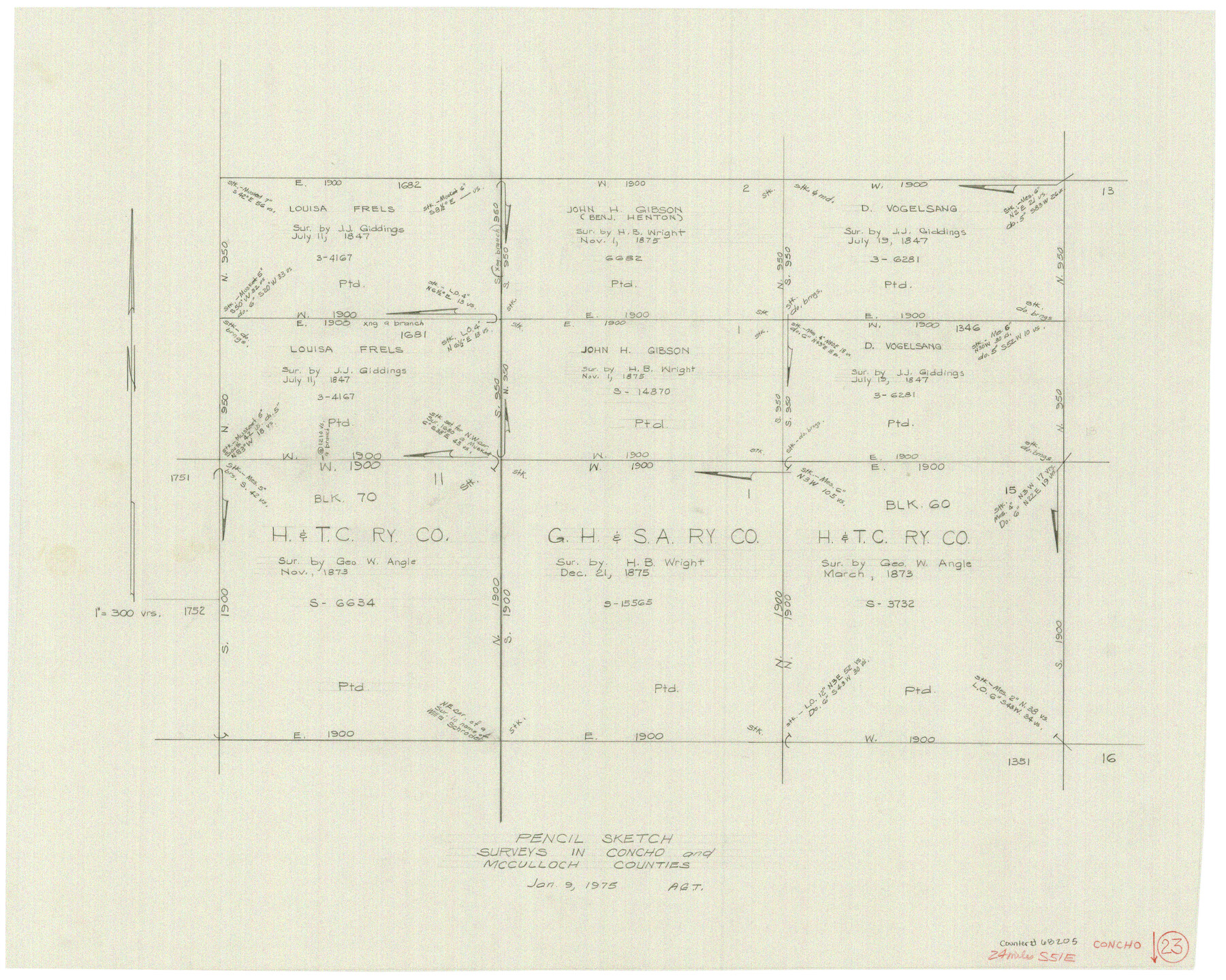
Concho County Working Sketch 23
-
Map/Doc
68205
-
Collection
General Map Collection
-
Object Dates
1/9/1975 (Creation Date)
-
Counties
Concho McCulloch
-
Subjects
Surveying Working Sketch
-
Height x Width
21.9 x 27.1 inches
55.6 x 68.8 cm
-
Scale
1" = 300 varas
Part of: General Map Collection
Flight Mission No. DAG-26K, Frame 59, Matagorda County

Print $20.00
- Digital $50.00
Flight Mission No. DAG-26K, Frame 59, Matagorda County
1953
Size 18.5 x 22.3 inches
Map/Doc 86579
Schleicher County Working Sketch 7

Print $20.00
- Digital $50.00
Schleicher County Working Sketch 7
1923
Size 22.4 x 14.7 inches
Map/Doc 63809
Terrell County Working Sketch 34

Print $20.00
- Digital $50.00
Terrell County Working Sketch 34
1945
Size 26.3 x 37.7 inches
Map/Doc 62126
Jefferson County Working Sketch 38

Print $20.00
- Digital $50.00
Jefferson County Working Sketch 38
1984
Size 32.6 x 43.2 inches
Map/Doc 66582
Pecos County Rolled Sketch 103

Print $20.00
- Digital $50.00
Pecos County Rolled Sketch 103
1940
Size 27.5 x 32.4 inches
Map/Doc 7251
Harrison County Rolled Sketch 14

Print $20.00
- Digital $50.00
Harrison County Rolled Sketch 14
1968
Size 25.8 x 20.0 inches
Map/Doc 6157
Fayette County Working Sketch 10

Print $20.00
- Digital $50.00
Fayette County Working Sketch 10
1985
Size 27.1 x 38.5 inches
Map/Doc 69174
Real County Working Sketch 8

Print $20.00
- Digital $50.00
Real County Working Sketch 8
1928
Size 38.1 x 44.3 inches
Map/Doc 71900
Smith County Working Sketch 6

Print $20.00
- Digital $50.00
Smith County Working Sketch 6
1940
Size 15.7 x 25.7 inches
Map/Doc 63891

Shelby County

Print $20.00
- Digital $50.00
Shelby County
1945
Size 39.1 x 44.2 inches
Map/Doc 77421
You may also like
Pecos County Sketch File 99

Print $16.00
- Digital $50.00
Pecos County Sketch File 99
Size 11.2 x 8.8 inches
Map/Doc 34004
Lee County Working Sketch 10

Print $20.00
- Digital $50.00
Lee County Working Sketch 10
1979
Size 32.6 x 35.4 inches
Map/Doc 70389
Fisher County Sketch File A2

Print $20.00
- Digital $50.00
Fisher County Sketch File A2
1901
Size 35.8 x 31.0 inches
Map/Doc 10450
Nacogdoches County Working Sketch 4

Print $20.00
- Digital $50.00
Nacogdoches County Working Sketch 4
1946
Size 22.2 x 23.2 inches
Map/Doc 71220
Kimble County Rolled Sketch 33

Print $20.00
- Digital $50.00
Kimble County Rolled Sketch 33
1973
Size 26.7 x 20.1 inches
Map/Doc 6523
Smith County Sketch File 18

Print $42.00
- Digital $50.00
Smith County Sketch File 18
1850
Size 24.8 x 19.3 inches
Map/Doc 76752
Upton County Working Sketch 37

Print $20.00
- Digital $50.00
Upton County Working Sketch 37
1957
Size 41.1 x 36.9 inches
Map/Doc 69533
Brewster County Rolled Sketch 114

Print $20.00
- Digital $50.00
Brewster County Rolled Sketch 114
1964
Size 11.4 x 18.4 inches
Map/Doc 5277
Kleberg County Rolled Sketch 10-3

Print $20.00
- Digital $50.00
Kleberg County Rolled Sketch 10-3
1951
Size 37.5 x 32.0 inches
Map/Doc 9388
Thomas Kelly Subdivision in Parmer and Castro Counties, Texas

Print $20.00
- Digital $50.00
Thomas Kelly Subdivision in Parmer and Castro Counties, Texas
1906
Size 20.4 x 16.6 inches
Map/Doc 92549
Eastland County Working Sketch 56

Print $20.00
- Digital $50.00
Eastland County Working Sketch 56
1984
Size 39.2 x 43.3 inches
Map/Doc 68837
United States

Print $20.00
- Digital $50.00
United States
1838
Size 12.2 x 19.6 inches
Map/Doc 97099