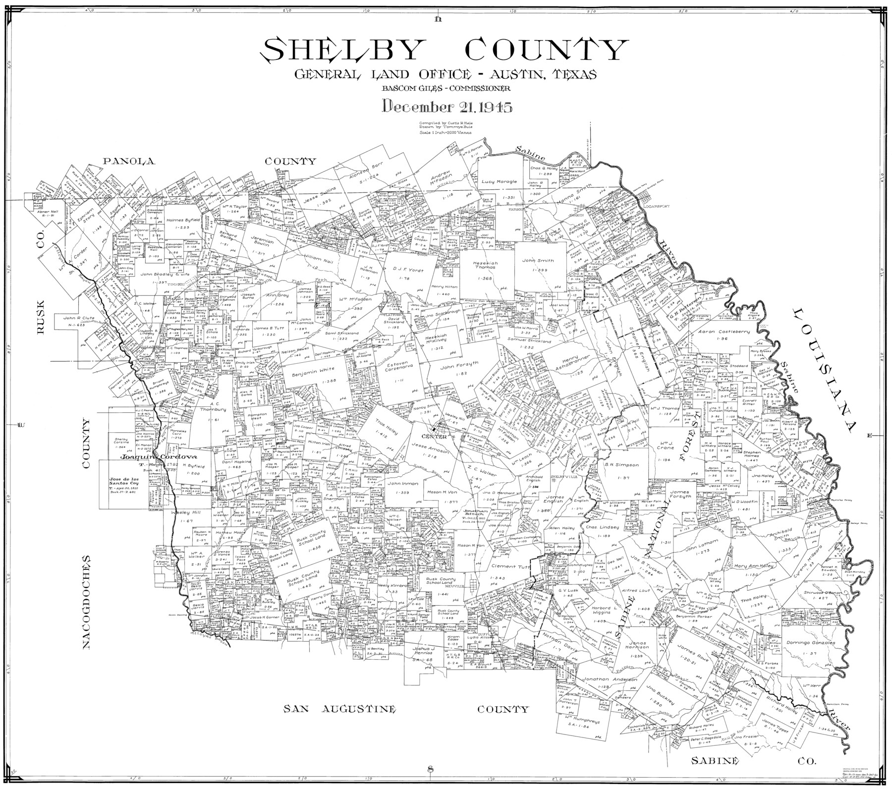
Shelby County
-
Map/Doc
77421
-
Collection
General Map Collection
-
Object Dates
1945/12/21 (Creation Date)
-
People and Organizations
Curtis R. Hale (Compiler)
Tommye Buie (Draftsman)
-
Counties
Shelby
-
Subjects
County
-
Height x Width
39.1 x 44.2 inches
99.3 x 112.3 cm
Part of: General Map Collection
Flight Mission No. DAH-17M, Frame 31, Orange County

Print $20.00
- Digital $50.00
Flight Mission No. DAH-17M, Frame 31, Orange County
1953
Size 18.7 x 22.5 inches
Map/Doc 86894
[Surveys in Milam's Colony along the Colorado River and Onion Creek]
![91, [Surveys in Milam's Colony along the Colorado River and Onion Creek], General Map Collection](https://historictexasmaps.com/wmedia_w700/maps/91.tif.jpg)
Print $20.00
- Digital $50.00
[Surveys in Milam's Colony along the Colorado River and Onion Creek]
1835
Size 24.7 x 25.0 inches
Map/Doc 91
Childress County Working Sketch 6

Print $20.00
- Digital $50.00
Childress County Working Sketch 6
1954
Size 19.1 x 24.3 inches
Map/Doc 68022


Galveston County

Print $40.00
- Digital $50.00
Galveston County
1939
Size 45.0 x 56.5 inches
Map/Doc 95505
Coleman County Sketch File 44

Print $17.00
- Digital $50.00
Coleman County Sketch File 44
Size 14.1 x 8.6 inches
Map/Doc 18783
Duval County Sketch File 19b

Print $6.00
- Digital $50.00
Duval County Sketch File 19b
Size 15.4 x 9.7 inches
Map/Doc 21320
San Patricio County Sketch File 9

Print $2.00
- Digital $50.00
San Patricio County Sketch File 9
1846
Size 8.3 x 8.7 inches
Map/Doc 36039
Bandera County Working Sketch 39

Print $20.00
- Digital $50.00
Bandera County Working Sketch 39
1975
Size 22.1 x 25.3 inches
Map/Doc 67635
Trinity River, OwenCrossing Sheet/Elm Fork of Trinity River

Print $20.00
- Digital $50.00
Trinity River, OwenCrossing Sheet/Elm Fork of Trinity River
1914
Size 29.2 x 29.4 inches
Map/Doc 78340
Frio County Rolled Sketch 23

Print $20.00
- Digital $50.00
Frio County Rolled Sketch 23
1962
Size 39.4 x 40.8 inches
Map/Doc 8912
You may also like
Concho County Sketch File 26

Print $6.00
- Digital $50.00
Concho County Sketch File 26
1885
Size 11.5 x 9.0 inches
Map/Doc 19159
Clay County Sketch File 49

Print $78.00
- Digital $50.00
Clay County Sketch File 49
1928
Size 14.2 x 8.8 inches
Map/Doc 18500
El Paso County

Print $40.00
- Digital $50.00
El Paso County
1881
Size 51.5 x 15.7 inches
Map/Doc 89057

Jefferson County Working Sketch 3

Print $20.00
- Digital $50.00
Jefferson County Working Sketch 3
1904
Size 25.1 x 21.2 inches
Map/Doc 66546

Flight Mission No. CGI-3N, Frame 168, Cameron County

Print $20.00
- Digital $50.00
Flight Mission No. CGI-3N, Frame 168, Cameron County
1954
Size 18.5 x 22.6 inches
Map/Doc 84632
Navarro County Working Sketch 16

Print $20.00
- Digital $50.00
Navarro County Working Sketch 16
1993
Size 15.8 x 17.7 inches
Map/Doc 71246
[T. & P. Block 35, Townships 4N and 5N]
![90629, [T. & P. Block 35, Townships 4N and 5N], Twichell Survey Records](https://historictexasmaps.com/wmedia_w700/maps/90629-1.tif.jpg)
Print $20.00
- Digital $50.00
[T. & P. Block 35, Townships 4N and 5N]
Size 26.3 x 34.7 inches
Map/Doc 90629
Lipscomb County Boundary File 14

Print $62.00
- Digital $50.00
Lipscomb County Boundary File 14
Size 13.3 x 8.8 inches
Map/Doc 56355

Potter County Working Sketch 6

Print $20.00
- Digital $50.00
Potter County Working Sketch 6
1959
Size 23.3 x 27.0 inches
Map/Doc 71666