Clay County Sketch File 49
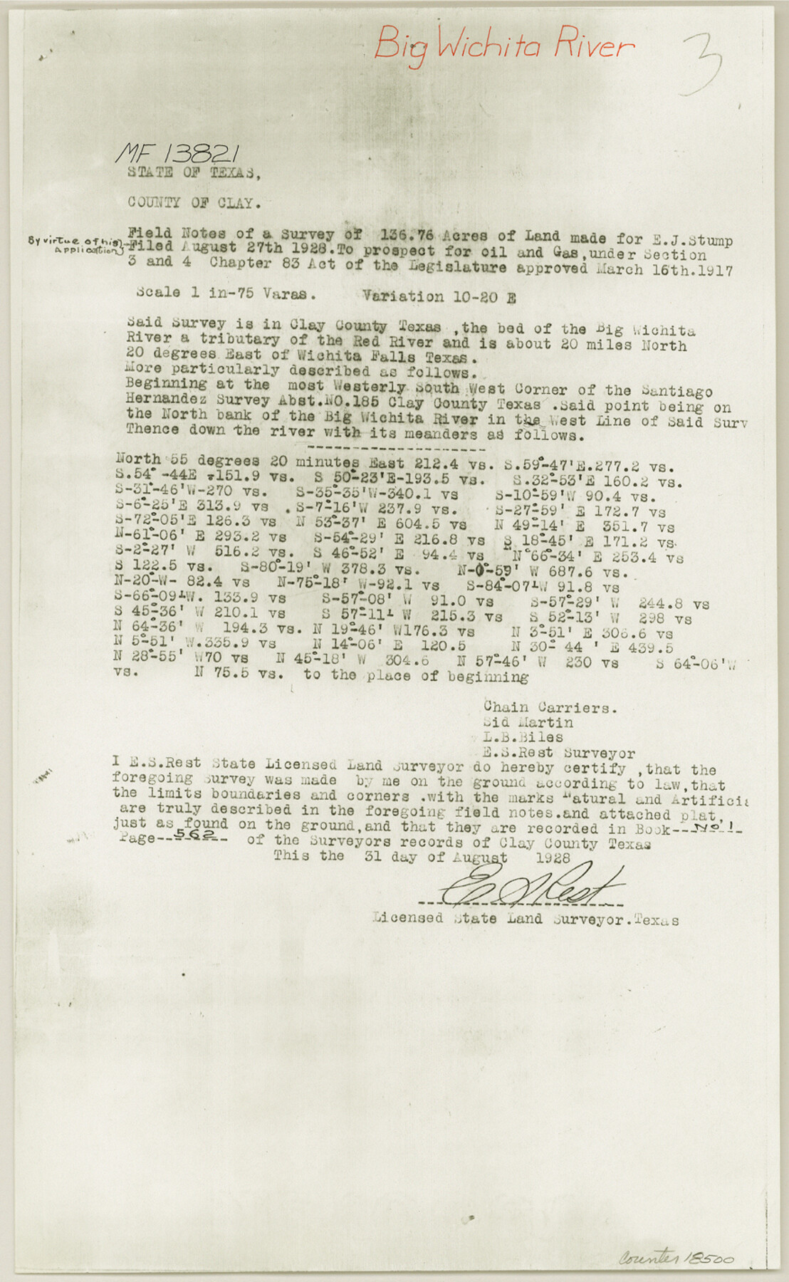
[Copies of field notes and sketches from MF-13821, MF-8759 and MF-5574, Big Wichita River]
-
Map/Doc
18500
-
Collection
General Map Collection
-
Object Dates
1928 (Creation Date)
1983/6/23 (File Date)
-
People and Organizations
E.S. Rest (Surveyor/Engineer)
R.W. Watkins (Surveyor/Engineer)
-
Counties
Clay Wichita
-
Subjects
Surveying Sketch File
-
Height x Width
14.2 x 8.8 inches
36.1 x 22.4 cm
-
Medium
paper, photocopy
-
Features
Big Wichita River
Red River
Wichita Falls
Part of: General Map Collection
Map of Taylor, Bastrop & Houston Railroad in Austin County

Print $20.00
- Digital $50.00
Map of Taylor, Bastrop & Houston Railroad in Austin County
Size 14.6 x 25.1 inches
Map/Doc 64480
Stonewall County Boundary File 2

Print $12.00
- Digital $50.00
Stonewall County Boundary File 2
Size 14.2 x 8.8 inches
Map/Doc 58955
Map of Young County

Print $20.00
- Digital $50.00
Map of Young County
1897
Size 44.1 x 37.9 inches
Map/Doc 63140
DeWitt County Working Sketch 9

Print $20.00
- Digital $50.00
DeWitt County Working Sketch 9
1979
Size 15.7 x 23.4 inches
Map/Doc 68599
Midland County Working Sketch 21

Print $40.00
- Digital $50.00
Midland County Working Sketch 21
1956
Size 69.0 x 27.9 inches
Map/Doc 71002
Parker County Sketch File 34

Print $20.00
- Digital $50.00
Parker County Sketch File 34
1878
Size 21.3 x 13.6 inches
Map/Doc 12148

San Jacinto County Sketch File 9

Print $4.00
San Jacinto County Sketch File 9
1860
Size 8.7 x 11.7 inches
Map/Doc 35712
Topographical Map of the Rio Grande, Sheet No. 5

Print $20.00
- Digital $50.00
Topographical Map of the Rio Grande, Sheet No. 5
1912
Map/Doc 89529

Knox County Sketch File 17

Print $20.00
- Digital $50.00
Knox County Sketch File 17
1902
Size 18.4 x 25.0 inches
Map/Doc 11960
Flight Mission No. DAG-23K, Frame 152, Matagorda County

Print $20.00
- Digital $50.00
Flight Mission No. DAG-23K, Frame 152, Matagorda County
1953
Size 15.9 x 15.9 inches
Map/Doc 86500
You may also like
Brazoria County Rolled Sketch 23

Print $20.00
- Digital $50.00
Brazoria County Rolled Sketch 23
1931
Size 39.2 x 37.3 inches
Map/Doc 10691
[Blocks Surrounding Block T]
![92891, [Blocks Surrounding Block T], Twichell Survey Records](https://historictexasmaps.com/wmedia_w700/maps/92891-1.tif.jpg)
Print $20.00
- Digital $50.00
[Blocks Surrounding Block T]
Size 20.8 x 24.3 inches
Map/Doc 92891
Zavala County Rolled Sketch 31

Print $20.00
- Digital $50.00
Zavala County Rolled Sketch 31
1883
Size 37.4 x 27.1 inches
Map/Doc 8332
Texas Gulf Coast, from the Sabine River to the Rio Grande as Subdivided for Mineral Development; Aransas, Nueces, Kleberg, Kenedy, Willacy, and Cameron Counties

Print $40.00
- Digital $50.00
Texas Gulf Coast, from the Sabine River to the Rio Grande as Subdivided for Mineral Development; Aransas, Nueces, Kleberg, Kenedy, Willacy, and Cameron Counties
1976
Size 118.0 x 43.0 inches
Map/Doc 1940
Jefferson County Rolled Sketch 32

Print $40.00
- Digital $50.00
Jefferson County Rolled Sketch 32
1955
Size 26.4 x 49.3 inches
Map/Doc 9295
[Blocks T1, T2, T3, and Vicinity]
![90983, [Blocks T1, T2, T3, and Vicinity], Twichell Survey Records](https://historictexasmaps.com/wmedia_w700/maps/90983-1.tif.jpg)
Print $20.00
- Digital $50.00
[Blocks T1, T2, T3, and Vicinity]
Size 30.3 x 33.6 inches
Map/Doc 90983
Hutchinson County Rolled Sketch 6

Print $20.00
- Digital $50.00
Hutchinson County Rolled Sketch 6
1906
Size 33.2 x 24.2 inches
Map/Doc 6278
McCulloch County Working Sketch 6

Print $20.00
- Digital $50.00
McCulloch County Working Sketch 6
1961
Size 15.2 x 23.9 inches
Map/Doc 70681
[Section 34 1/2 and Blk.194, Jno. H. Tyler and Bob Reid Surveys, Yates Field]
![91622, [Section 34 1/2 and Blk.194, Jno. H. Tyler and Bob Reid Surveys, Yates Field], Twichell Survey Records](https://historictexasmaps.com/wmedia_w700/maps/91622-1.tif.jpg)
Print $20.00
- Digital $50.00
[Section 34 1/2 and Blk.194, Jno. H. Tyler and Bob Reid Surveys, Yates Field]
Size 22.7 x 20.6 inches
Map/Doc 91622
[Leagues 1, 2, 281, 282, 284, and 285]
![92563, [Leagues 1, 2, 281, 282, 284, and 285], Twichell Survey Records](https://historictexasmaps.com/wmedia_w700/maps/92563-1.tif.jpg)
Print $20.00
- Digital $50.00
[Leagues 1, 2, 281, 282, 284, and 285]
Size 23.8 x 19.3 inches
Map/Doc 92563
Presidio County Working Sketch 120

Print $20.00
- Digital $50.00
Presidio County Working Sketch 120
1984
Size 34.6 x 28.9 inches
Map/Doc 71797
Wichita County Sketch File R

Print $8.00
- Digital $50.00
Wichita County Sketch File R
Size 14.3 x 8.8 inches
Map/Doc 40142