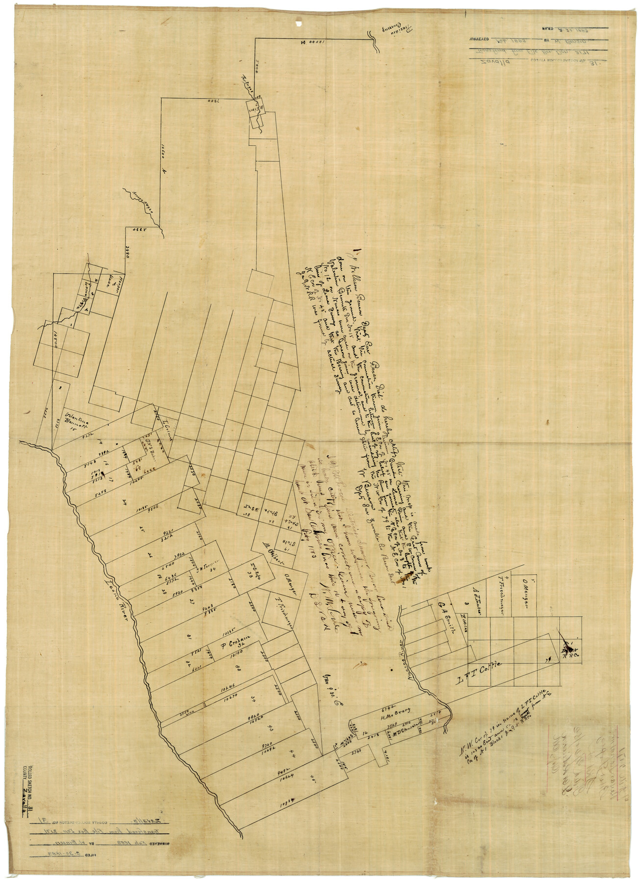
Zavala County Rolled Sketch 31
[Sketch of surveys along west bank of Leona River and surrounding area]
-
Map/Doc
8332
-
Collection
General Map Collection
-
Object Dates
2/1883 (Creation Date)
2/20/1883 (File Date)
-
People and Organizations
W. Benson (Surveyor/Engineer)
-
Counties
Zavala
-
Subjects
Surveying Rolled Sketch
-
Height x Width
37.4 x 27.1 inches
95.0 x 68.8 cm
-
Medium
linen, manuscript
-
Comments
Transferred from file Bexar Donation 2171.
Part of: General Map Collection
Hopkins County Rolled Sketch 28

Print $20.00
- Digital $50.00
Hopkins County Rolled Sketch 28
Size 25.3 x 19.9 inches
Map/Doc 6225
Lynn County Sketch File 2

Print $5.00
- Digital $50.00
Lynn County Sketch File 2
1902
Size 11.6 x 17.1 inches
Map/Doc 30447
Karnes County Working Sketch Graphic Index

Print $20.00
- Digital $50.00
Karnes County Working Sketch Graphic Index
1921
Size 45.0 x 40.3 inches
Map/Doc 76600
Marion County Sketch File 16

Print $20.00
- Digital $50.00
Marion County Sketch File 16
1954
Size 22.9 x 23.2 inches
Map/Doc 12025
Howard County

Print $20.00
- Digital $50.00
Howard County
1922
Size 44.0 x 37.5 inches
Map/Doc 66872
Hutchinson County Rolled Sketch 44-15

Print $20.00
- Digital $50.00
Hutchinson County Rolled Sketch 44-15
2002
Size 24.0 x 36.0 inches
Map/Doc 77551
Aransas County NRC Article 33.136 Sketch 13

Print $24.00
- Digital $50.00
Aransas County NRC Article 33.136 Sketch 13
Size 24.0 x 36.0 inches
Map/Doc 94514
San Jacinto County Working Sketch 22

Print $20.00
- Digital $50.00
San Jacinto County Working Sketch 22
1940
Size 21.3 x 25.3 inches
Map/Doc 63735
Caldwell County Sketch File 4a

Print $8.00
- Digital $50.00
Caldwell County Sketch File 4a
1898
Size 11.2 x 8.8 inches
Map/Doc 35835
Colorado County Working Sketch 13

Print $20.00
- Digital $50.00
Colorado County Working Sketch 13
1943
Size 37.9 x 23.3 inches
Map/Doc 68113
Kendall County Sketch File 13

Print $4.00
- Digital $50.00
Kendall County Sketch File 13
1860
Size 10.1 x 8.0 inches
Map/Doc 28699
McClennan County, Robertson District East of the Brazos, Milam District West of the Brazos
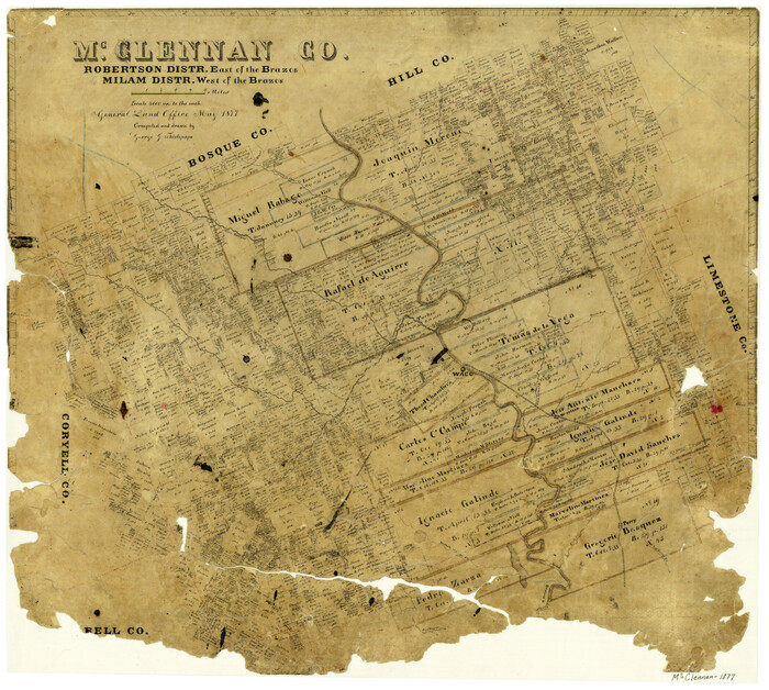
Print $20.00
- Digital $50.00
McClennan County, Robertson District East of the Brazos, Milam District West of the Brazos
1877
Size 21.9 x 24.5 inches
Map/Doc 3864
You may also like
Flight Mission No. BRE-1P, Frame 119, Nueces County

Print $20.00
- Digital $50.00
Flight Mission No. BRE-1P, Frame 119, Nueces County
1956
Size 18.7 x 22.7 inches
Map/Doc 86685
Presidio County Sketch File P2

Print $6.00
- Digital $50.00
Presidio County Sketch File P2
Size 14.3 x 8.9 inches
Map/Doc 34558
Street guide and metropolitan map of New Orleans [Recto]
![94198, Street guide and metropolitan map of New Orleans [Recto], General Map Collection](https://historictexasmaps.com/wmedia_w700/maps/94198.tif.jpg)
Street guide and metropolitan map of New Orleans [Recto]
1963
Size 18.3 x 27.2 inches
Map/Doc 94198
Flight Mission No. BQY-15M, Frame 8, Harris County

Print $20.00
- Digital $50.00
Flight Mission No. BQY-15M, Frame 8, Harris County
1953
Size 18.7 x 22.4 inches
Map/Doc 85306
The Republic County of Nacogdoches. February 1, 1842

Print $20.00
The Republic County of Nacogdoches. February 1, 1842
2020
Size 15.9 x 21.8 inches
Map/Doc 96247
Jackson County Boundary File 2

Print $22.00
- Digital $50.00
Jackson County Boundary File 2
Size 8.6 x 4.1 inches
Map/Doc 55437
Shelby County Working Sketch 19

Print $20.00
- Digital $50.00
Shelby County Working Sketch 19
1969
Size 36.9 x 30.2 inches
Map/Doc 63872
Bowie County Working Sketch 3

Print $20.00
- Digital $50.00
Bowie County Working Sketch 3
1913
Size 25.5 x 17.1 inches
Map/Doc 67407
Tom Green County Sketch File 16

Print $16.00
- Digital $50.00
Tom Green County Sketch File 16
Size 8.5 x 7.8 inches
Map/Doc 38174
Military Reconnaissance of the Arkansas Rio Del Norte and Rio Gila

Print $40.00
- Digital $50.00
Military Reconnaissance of the Arkansas Rio Del Norte and Rio Gila
1847
Size 33.0 x 72.2 inches
Map/Doc 552
Brazoria County Sketch File 52

Print $6.00
- Digital $50.00
Brazoria County Sketch File 52
Size 14.5 x 8.0 inches
Map/Doc 15313
Kenedy County Aerial Photograph Index Sheet 5

Print $20.00
- Digital $50.00
Kenedy County Aerial Photograph Index Sheet 5
1943
Size 23.5 x 19.6 inches
Map/Doc 89046