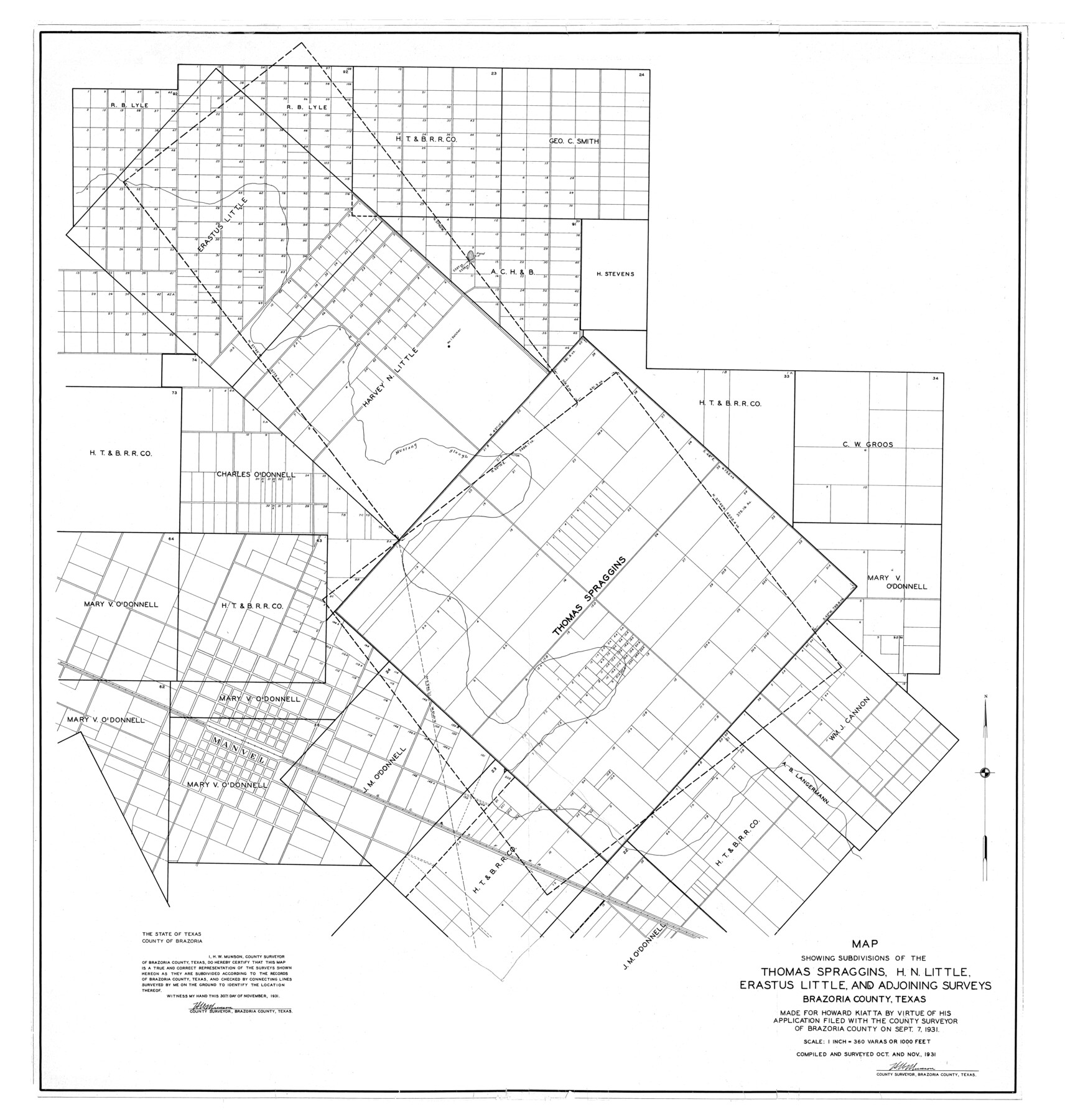
Brazoria County Rolled Sketch 23
Map showing subdivisions of the Thomas Spraggins, H.N. Little, Erastus Little, and adjoining surveys
-
Map/Doc
10691
-
Collection
General Map Collection
-
Object Dates
1931/11/30 (Creation Date)
1931/12/9 (File Date)
-
People and Organizations
H.W. Munson (Surveyor/Engineer)
-
Counties
Brazoria
-
Subjects
City Surveying Rolled Sketch
-
Height x Width
39.2 x 37.3 inches
99.6 x 94.7 cm
-
Medium
blueprint/diazo
-
Scale
1" = 360 varas
-
Comments
See surveyor's report in SF-13286
Part of: General Map Collection
Newton County Working Sketch 13

Print $20.00
- Digital $50.00
Newton County Working Sketch 13
1946
Size 34.4 x 34.2 inches
Map/Doc 71259
Kaufman County

Print $20.00
- Digital $50.00
Kaufman County
1871
Size 22.3 x 15.0 inches
Map/Doc 3750
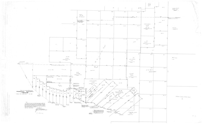
Presidio County Rolled Sketch D3
Print $40.00
- Digital $50.00
Presidio County Rolled Sketch D3
1909
Size 35.1 x 56.3 inches
Map/Doc 9776
Old Miscellaneous File 27a

Print $142.00
- Digital $50.00
Old Miscellaneous File 27a
Size 14.2 x 8.8 inches
Map/Doc 75651
[Surveys in the Bexar District along the Nueces and Leona Rivers]
![116, [Surveys in the Bexar District along the Nueces and Leona Rivers], General Map Collection](https://historictexasmaps.com/wmedia_w700/maps/116.tif.jpg)
Print $3.00
- Digital $50.00
[Surveys in the Bexar District along the Nueces and Leona Rivers]
1845
Size 10.9 x 14.3 inches
Map/Doc 116
Montgomery County Working Sketch 61

Print $20.00
- Digital $50.00
Montgomery County Working Sketch 61
1963
Size 25.6 x 19.9 inches
Map/Doc 71168
Kleberg County Boundary File 2a

Print $40.00
- Digital $50.00
Kleberg County Boundary File 2a
Size 15.4 x 58.3 inches
Map/Doc 64977
Frio County Sketch File A

Print $40.00
- Digital $50.00
Frio County Sketch File A
1878
Size 16.4 x 13.4 inches
Map/Doc 23099
Texas Gulf Coast Map from the Sabine River to the Rio Grande as subdivided for mineral development

Print $20.00
- Digital $50.00
Texas Gulf Coast Map from the Sabine River to the Rio Grande as subdivided for mineral development
1948
Size 41.6 x 39.2 inches
Map/Doc 2904
Flight Mission No. DAG-17K, Frame 66, Matagorda County

Print $20.00
- Digital $50.00
Flight Mission No. DAG-17K, Frame 66, Matagorda County
1952
Size 18.5 x 22.3 inches
Map/Doc 86328
Runnels County Working Sketch 9

Print $40.00
- Digital $50.00
Runnels County Working Sketch 9
1948
Size 48.9 x 27.9 inches
Map/Doc 63605
Atascosa County Working Sketch 37

Print $20.00
- Digital $50.00
Atascosa County Working Sketch 37
2004
Size 23.2 x 24.1 inches
Map/Doc 89049
You may also like
Lloyd's Map of the Southern States showing all the Railroads, their Stations & Distances, also the Counties, Towns, Villages, Harbors, Rivers, and Forts

Print $40.00
- Digital $50.00
Lloyd's Map of the Southern States showing all the Railroads, their Stations & Distances, also the Counties, Towns, Villages, Harbors, Rivers, and Forts
1861
Size 39.3 x 54.4 inches
Map/Doc 96556
[West half of Deaf Smith County showing School Land Leagues]
![90612, [West half of Deaf Smith County showing School Land Leagues], Twichell Survey Records](https://historictexasmaps.com/wmedia_w700/maps/90612-1.tif.jpg)
Print $20.00
- Digital $50.00
[West half of Deaf Smith County showing School Land Leagues]
Size 31.4 x 18.3 inches
Map/Doc 90612
Henderson County Sketch File 21

Print $20.00
- Digital $50.00
Henderson County Sketch File 21
1941
Size 27.8 x 17.9 inches
Map/Doc 11758
Galveston County Rolled Sketch 43A

Print $20.00
- Digital $50.00
Galveston County Rolled Sketch 43A
Size 16.2 x 20.3 inches
Map/Doc 76005
Duval County Working Sketch 25

Print $20.00
- Digital $50.00
Duval County Working Sketch 25
1946
Size 23.7 x 20.1 inches
Map/Doc 68749
Calhoun County Sketch File 8

Print $12.00
- Digital $50.00
Calhoun County Sketch File 8
1948
Size 14.2 x 9.0 inches
Map/Doc 35930
Military Reconstruction Districts

Military Reconstruction Districts
2024
Size 8.5 x 11.0 inches
Map/Doc 97345
Red River County Working Sketch 68

Print $20.00
- Digital $50.00
Red River County Working Sketch 68
1975
Size 20.8 x 26.0 inches
Map/Doc 72051
Flight Mission No. CGI-3N, Frame 42, Cameron County

Print $20.00
- Digital $50.00
Flight Mission No. CGI-3N, Frame 42, Cameron County
1954
Size 18.5 x 22.1 inches
Map/Doc 84548
Briscoe County Sketch File J

Print $40.00
- Digital $50.00
Briscoe County Sketch File J
1919
Size 19.3 x 32.0 inches
Map/Doc 11007
Hemphill County Working Sketch 16

Print $20.00
- Digital $50.00
Hemphill County Working Sketch 16
1971
Size 27.0 x 40.0 inches
Map/Doc 66111
Dawson County Sketch File A1

Print $20.00
- Digital $50.00
Dawson County Sketch File A1
1923
Size 14.8 x 33.4 inches
Map/Doc 11299