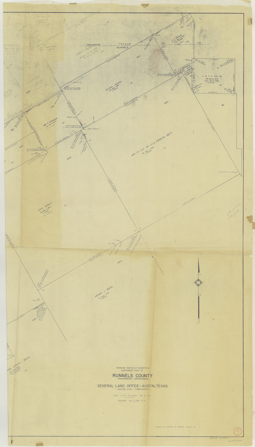
Runnels County Working Sketch 9
-
Map/Doc
63605
-
Collection
General Map Collection
-
Object Dates
3/9/1948 (Creation Date)
12/3/1948 (Revision Date)
-
Counties
Runnels
-
Subjects
Surveying Working Sketch
-
Height x Width
48.9 x 27.9 inches
124.2 x 70.9 cm
-
Comments
Segment 2; for segment 1 see map 69712.
Related maps
Runnels County Working Sketch 9

Print $40.00
- Digital $50.00
Runnels County Working Sketch 9
1948
Size 48.8 x 30.1 inches
Map/Doc 69712
Part of: General Map Collection
Cochran County Sketch File 5

Print $24.00
- Digital $50.00
Cochran County Sketch File 5
1932
Size 11.1 x 8.7 inches
Map/Doc 18542
Edwards County Working Sketch 10

Print $20.00
- Digital $50.00
Edwards County Working Sketch 10
1920
Size 21.9 x 18.3 inches
Map/Doc 68886
Jim Wells County Sketch File 2

Print $6.00
- Digital $50.00
Jim Wells County Sketch File 2
1931
Size 11.1 x 8.7 inches
Map/Doc 28424
Brazoria County Working Sketch 7

Print $20.00
- Digital $50.00
Brazoria County Working Sketch 7
1930
Size 40.9 x 21.1 inches
Map/Doc 67492
Liberty County Working Sketch 91

Print $40.00
- Digital $50.00
Liberty County Working Sketch 91
1919
Size 48.4 x 43.0 inches
Map/Doc 65459
Mills County Working Sketch 12

Print $20.00
- Digital $50.00
Mills County Working Sketch 12
1923
Size 22.1 x 26.3 inches
Map/Doc 71042
Outer Continental Shelf Leasing Maps (Louisiana Offshore Operations)

Print $20.00
- Digital $50.00
Outer Continental Shelf Leasing Maps (Louisiana Offshore Operations)
1959
Size 17.8 x 14.0 inches
Map/Doc 76106
Brazoria County Sketch File 21

Print $4.00
- Digital $50.00
Brazoria County Sketch File 21
Size 8.3 x 7.5 inches
Map/Doc 15016
Brazoria County Sketch File 14

Print $8.00
- Digital $50.00
Brazoria County Sketch File 14
1892
Size 13.9 x 8.7 inches
Map/Doc 14973
Crockett County Rolled Sketch 99

Print $20.00
- Digital $50.00
Crockett County Rolled Sketch 99
Size 37.2 x 38.2 inches
Map/Doc 95401
Franklin County Sketch File 16

Print $6.00
- Digital $50.00
Franklin County Sketch File 16
Size 13.2 x 8.2 inches
Map/Doc 23023
Flight Mission No. DQN-1K, Frame 51, Calhoun County

Print $20.00
- Digital $50.00
Flight Mission No. DQN-1K, Frame 51, Calhoun County
1953
Size 18.6 x 22.3 inches
Map/Doc 84151
You may also like
Montgomery County Working Sketch 57

Print $20.00
- Digital $50.00
Montgomery County Working Sketch 57
1961
Size 24.2 x 26.6 inches
Map/Doc 71164
Harrison County Sketch File 4

Print $4.00
- Digital $50.00
Harrison County Sketch File 4
Size 9.0 x 8.0 inches
Map/Doc 26040
Foard County Working Sketch 11

Print $20.00
- Digital $50.00
Foard County Working Sketch 11
1977
Size 26.7 x 35.6 inches
Map/Doc 69202
The Judicial District/County of Burleson. Abolished, Spring 1842

Print $20.00
The Judicial District/County of Burleson. Abolished, Spring 1842
2020
Size 14.1 x 21.7 inches
Map/Doc 96321
[Sketch of area just south of Levi Pruitt survey]
![91855, [Sketch of area just south of Levi Pruitt survey], Twichell Survey Records](https://historictexasmaps.com/wmedia_w700/maps/91855-1.tif.jpg)
Print $20.00
- Digital $50.00
[Sketch of area just south of Levi Pruitt survey]
1924
Size 17.0 x 17.8 inches
Map/Doc 91855
Copy of Surveyor's Field Book, Morris Browning - In Blocks 7, 5 & 4, I&GNRRCo., Hutchinson and Carson Counties, Texas

Print $2.00
- Digital $50.00
Copy of Surveyor's Field Book, Morris Browning - In Blocks 7, 5 & 4, I&GNRRCo., Hutchinson and Carson Counties, Texas
1888
Size 6.9 x 8.8 inches
Map/Doc 62281
General Highway Map. Detail of Cities and Towns in Bexar County, Texas [San Antonio and vicinity]
![79019, General Highway Map. Detail of Cities and Towns in Bexar County, Texas [San Antonio and vicinity], Texas State Library and Archives](https://historictexasmaps.com/wmedia_w700/maps/79019.tif.jpg)
Print $20.00
General Highway Map. Detail of Cities and Towns in Bexar County, Texas [San Antonio and vicinity]
1940
Size 18.6 x 25.0 inches
Map/Doc 79019
Cooke County Working Sketch 14

Print $40.00
- Digital $50.00
Cooke County Working Sketch 14
1944
Size 34.1 x 49.7 inches
Map/Doc 68251
San Antonio - as seen by a Northern Visitor

San Antonio - as seen by a Northern Visitor
1927
Size 10.6 x 7.9 inches
Map/Doc 97042
Leon County Boundary File 1

Print $34.00
- Digital $50.00
Leon County Boundary File 1
Size 21.0 x 6.6 inches
Map/Doc 56281

[Blocks 33-35, Township 5N]
![92029, [Blocks 33-35, Township 5N], Twichell Survey Records](https://historictexasmaps.com/wmedia_w700/maps/92029-1.tif.jpg)
Print $20.00
- Digital $50.00
[Blocks 33-35, Township 5N]
Size 37.4 x 23.8 inches
Map/Doc 92029