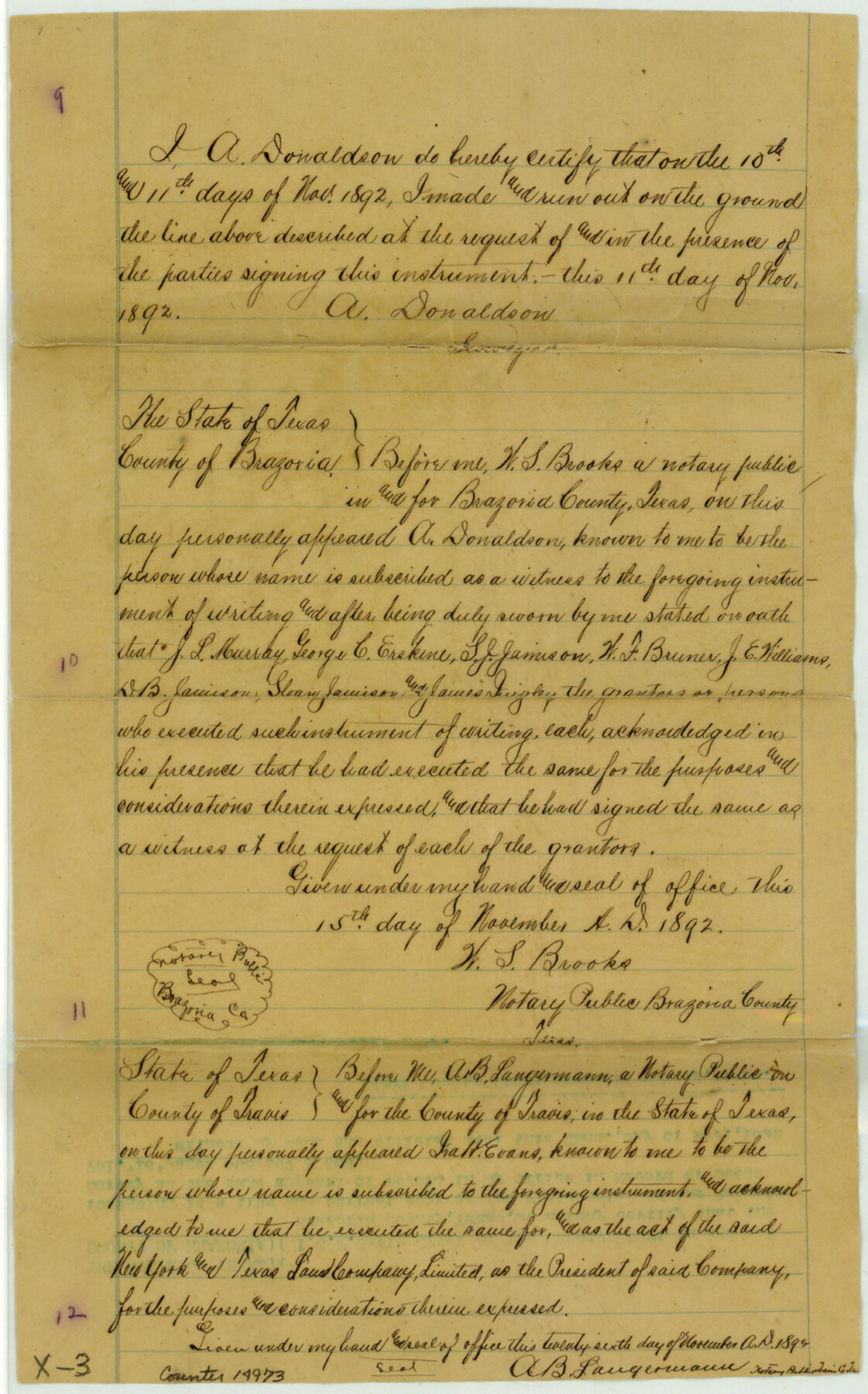
Brazoria County Sketch File 14
[Copy of agreement of owners as to boundaries of William Roberts league and A. Roberts labor on the west and the Jose de Jesus Valderas surveys on the east]
-
Map/Doc
14973
-
Collection
General Map Collection
-
Object Dates
1892/11/11 (Creation Date)
1892/12/23 (File Date)
-
People and Organizations
J.L. Murray (Landowner)
Geo. C. Erskine (Landowner)
S.J. Jamison (Landowner)
W.F. Bruner (Landowner)
J.E. Williams (Landowner)
D.B. Jamison (Landowner)
Sloan Jamison (Landowner)
James Quigley (Landowner)
A. Donaldson (Surveyor/Engineer)
-
Counties
Brazoria
-
Subjects
Surveying Sketch File
-
Height x Width
13.9 x 8.7 inches
35.3 x 22.1 cm
-
Medium
paper, manuscript
-
Comments
Landowners who were party to this agreement were: J.L. Murray, Geo. C. Erskine, S.J. Jamison, W.F. Bruner, J.E. Williams, D.B. Jamison, Sloan Jamison, James Quigley
Part of: General Map Collection
Current Miscellaneous File 119

Print $10.00
- Digital $50.00
Current Miscellaneous File 119
1990
Size 8.5 x 10.9 inches
Map/Doc 83397
Childress County Working Sketch Graphic Index

Print $20.00
- Digital $50.00
Childress County Working Sketch Graphic Index
1978
Size 45.5 x 34.3 inches
Map/Doc 76493
Flight Mission No. CRC-3R, Frame 43, Chambers County

Print $20.00
- Digital $50.00
Flight Mission No. CRC-3R, Frame 43, Chambers County
1956
Size 18.5 x 22.3 inches
Map/Doc 84816
Pecos County Rolled Sketch 44

Print $20.00
- Digital $50.00
Pecos County Rolled Sketch 44
1912
Size 22.9 x 37.6 inches
Map/Doc 7222
Upton County Rolled Sketch 59A

Print $20.00
- Digital $50.00
Upton County Rolled Sketch 59A
Size 35.4 x 45.6 inches
Map/Doc 76422
Crane County Sketch File 23a

Print $6.00
- Digital $50.00
Crane County Sketch File 23a
1931
Size 14.4 x 8.9 inches
Map/Doc 19593
Flight Mission No. CRC-3R, Frame 209, Chambers County

Print $20.00
- Digital $50.00
Flight Mission No. CRC-3R, Frame 209, Chambers County
1956
Size 18.6 x 22.3 inches
Map/Doc 84864
Edwards County Working Sketch 118

Print $20.00
- Digital $50.00
Edwards County Working Sketch 118
1974
Size 19.5 x 30.4 inches
Map/Doc 68994
Denison Dam Quadrangle

Print $20.00
- Digital $50.00
Denison Dam Quadrangle
1999
Size 35.4 x 23.4 inches
Map/Doc 97366
Erath County Working Sketch 2

Print $20.00
- Digital $50.00
Erath County Working Sketch 2
Size 18.0 x 22.6 inches
Map/Doc 69083
Ochiltree County Boundary File 5a

Print $10.00
- Digital $50.00
Ochiltree County Boundary File 5a
Size 13.7 x 8.7 inches
Map/Doc 57692
[Sketch for Mineral Applications 26885-6 - Reagan and Crockett Cos., W. H. Bland]
![2854, [Sketch for Mineral Applications 26885-6 - Reagan and Crockett Cos., W. H. Bland], General Map Collection](https://historictexasmaps.com/wmedia_w700/maps/2854.tif.jpg)
Print $20.00
- Digital $50.00
[Sketch for Mineral Applications 26885-6 - Reagan and Crockett Cos., W. H. Bland]
1932
Size 41.5 x 36.6 inches
Map/Doc 2854
You may also like
Presidio de San Antonio de Bejar

Presidio de San Antonio de Bejar
2006
Size 10.8 x 16.9 inches
Map/Doc 87385
Harris County NRC Article 33.136 Sketch 16

Print $20.00
- Digital $50.00
Harris County NRC Article 33.136 Sketch 16
2006
Size 24.0 x 36.0 inches
Map/Doc 94823
Travis County Sketch File 23

Print $4.00
- Digital $50.00
Travis County Sketch File 23
1875
Size 12.8 x 8.5 inches
Map/Doc 38330
Roberts County Working Sketch 38

Print $20.00
- Digital $50.00
Roberts County Working Sketch 38
1978
Size 26.7 x 22.5 inches
Map/Doc 63564
Leon County Rolled Sketch 30

Print $20.00
- Digital $50.00
Leon County Rolled Sketch 30
Size 30.9 x 25.7 inches
Map/Doc 6613
Brewster County Rolled Sketch 92

Print $20.00
- Digital $50.00
Brewster County Rolled Sketch 92
1950
Size 24.3 x 15.2 inches
Map/Doc 5250
Frio County Working Sketch 11

Print $20.00
- Digital $50.00
Frio County Working Sketch 11
1952
Size 22.9 x 20.0 inches
Map/Doc 69285
Trinity River, Sand Lake Sheet

Print $40.00
- Digital $50.00
Trinity River, Sand Lake Sheet
1922
Size 29.4 x 49.7 inches
Map/Doc 65184
Sterling County Working Sketch 7

Print $20.00
- Digital $50.00
Sterling County Working Sketch 7
1957
Size 22.1 x 26.1 inches
Map/Doc 63989
Flight Mission No. BRE-1P, Frame 8, Nueces County

Print $20.00
- Digital $50.00
Flight Mission No. BRE-1P, Frame 8, Nueces County
1956
Size 18.3 x 22.1 inches
Map/Doc 86616
Calcasieu Pass to Sabine Pass

Print $20.00
- Digital $50.00
Calcasieu Pass to Sabine Pass
1976
Size 44.6 x 35.3 inches
Map/Doc 69813
Aransas County Sketch File 11

Print $40.00
- Digital $50.00
Aransas County Sketch File 11
Size 40.6 x 31.4 inches
Map/Doc 10318