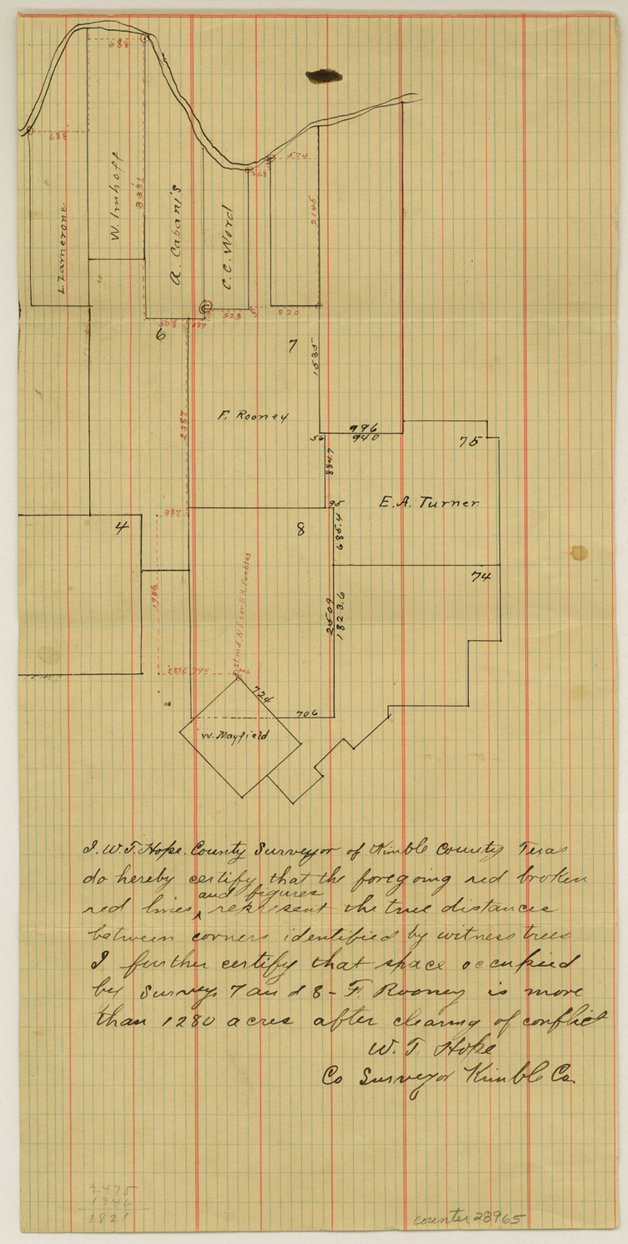
Kimble County Sketch File C
[Sketch of surveys between North and South Fork of Llano River, due west of Junction]
-
Map/Doc
28965
-
Collection
General Map Collection
-
Object Dates
12/3/1900 (File Date)
-
People and Organizations
W.T. Hope (Surveyor/Engineer)
-
Counties
Kimble
-
Subjects
Surveying Sketch File
-
Height x Width
14.9 x 7.5 inches
37.9 x 19.1 cm
-
Medium
paper, manuscript
Part of: General Map Collection
Sherman County Boundary File Index

Print $2.00
- Digital $50.00
Sherman County Boundary File Index
Size 8.8 x 13.2 inches
Map/Doc 58750
Castro County Working Sketch Graphic Index

Print $20.00
- Digital $50.00
Castro County Working Sketch Graphic Index
1932
Size 43.1 x 38.2 inches
Map/Doc 76490
Lynn County Sketch File 18

Print $4.00
- Digital $50.00
Lynn County Sketch File 18
1940
Size 11.2 x 8.8 inches
Map/Doc 30514
McMullen County Working Sketch 28

Print $20.00
- Digital $50.00
McMullen County Working Sketch 28
1954
Size 25.6 x 22.4 inches
Map/Doc 70729
Erath County Sketch File 15

Print $4.00
- Digital $50.00
Erath County Sketch File 15
1872
Size 6.2 x 7.6 inches
Map/Doc 22292
Moore County Sketch File 5

Print $22.00
- Digital $50.00
Moore County Sketch File 5
Size 9.0 x 12.6 inches
Map/Doc 31937
Dickens County Sketch File 19

Print $4.00
- Digital $50.00
Dickens County Sketch File 19
1910
Size 8.4 x 7.5 inches
Map/Doc 20982
Irion County Rolled Sketch 17

Print $20.00
- Digital $50.00
Irion County Rolled Sketch 17
1956
Size 40.5 x 40.2 inches
Map/Doc 9255
Hidalgo County Rolled Sketch 8

Print $20.00
- Digital $50.00
Hidalgo County Rolled Sketch 8
1905
Size 20.1 x 26.3 inches
Map/Doc 6209
[Map of Hunt County]
![3691, [Map of Hunt County], General Map Collection](https://historictexasmaps.com/wmedia_w700/maps/3691-1.tif.jpg)
Print $20.00
- Digital $50.00
[Map of Hunt County]
1851
Size 21.6 x 19.1 inches
Map/Doc 3691
Bastrop County Working Sketch 10

Print $20.00
- Digital $50.00
Bastrop County Working Sketch 10
1968
Size 31.9 x 37.7 inches
Map/Doc 67310
Garza County Rolled Sketch 17

Print $20.00
- Digital $50.00
Garza County Rolled Sketch 17
1959
Size 32.3 x 37.6 inches
Map/Doc 6003
You may also like
Hardeman County

Print $20.00
- Digital $50.00
Hardeman County
1935
Size 44.4 x 41.4 inches
Map/Doc 73170
Map of El Paso County

Print $20.00
- Digital $50.00
Map of El Paso County
1888
Size 47.1 x 39.5 inches
Map/Doc 4942
Jefferson County Rolled Sketch 61D

Print $20.00
- Digital $50.00
Jefferson County Rolled Sketch 61D
Size 27.2 x 40.5 inches
Map/Doc 6413
Geographical Observations on the Inner Margins of the Border and Coastal Reserves of Texas, 1824-1836

Geographical Observations on the Inner Margins of the Border and Coastal Reserves of Texas, 1824-1836
2022
Map/Doc 97131
Angelina County Sketch File 20

Print $40.00
- Digital $50.00
Angelina County Sketch File 20
1882
Size 19.7 x 29.4 inches
Map/Doc 10816
Madison County Working Sketch 9

Print $20.00
- Digital $50.00
Madison County Working Sketch 9
1982
Size 15.7 x 21.1 inches
Map/Doc 70771
Flight Mission No. CGI-1N, Frame 218, Cameron County

Print $20.00
- Digital $50.00
Flight Mission No. CGI-1N, Frame 218, Cameron County
1955
Size 18.6 x 22.1 inches
Map/Doc 84527
Texas and Mexico showing Houston and Texas Central System of Railways

Print $20.00
- Digital $50.00
Texas and Mexico showing Houston and Texas Central System of Railways
1885
Size 29.0 x 21.6 inches
Map/Doc 94274
Motley County, Texas

Print $20.00
- Digital $50.00
Motley County, Texas
1883
Size 23.6 x 20.7 inches
Map/Doc 743
Parker County Sketch File 1

Print $4.00
- Digital $50.00
Parker County Sketch File 1
Size 8.5 x 10.4 inches
Map/Doc 33516
Clay County Working Sketch 12

Print $20.00
- Digital $50.00
Clay County Working Sketch 12
1955
Size 30.6 x 39.4 inches
Map/Doc 68035
Bailey County Sketch File 8

Print $6.00
- Digital $50.00
Bailey County Sketch File 8
1913
Size 8.8 x 14.3 inches
Map/Doc 13962