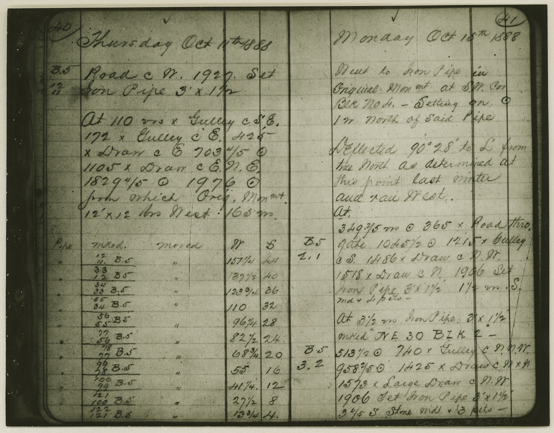
Copy of Surveyor's Field Book, Morris Browning - In Blocks 7, 5 & 4, I&GNRRCo., Hutchinson and Carson Counties, Texas
K-7-70
-
Map/Doc
62281
-
Collection
General Map Collection
-
Object Dates
1888/10/22 (Creation Date)
-
People and Organizations
Morris Browning (Surveyor/Engineer)
-
Counties
Hutchinson Carson
-
Height x Width
6.9 x 8.8 inches
17.5 x 22.4 cm
-
Comments
Copy of Surveyor's field book presented to the General Land Office by Morris Browning on February 3, 1941.
Surveyed from September 14, 1888 to October 22, 1888.
Part of: General Map Collection
San Patricio County NRC Article 33.136 Location Key Sheet

Print $20.00
- Digital $50.00
San Patricio County NRC Article 33.136 Location Key Sheet
1975
Size 27.0 x 23.0 inches
Map/Doc 77036
Sterling County

Print $20.00
- Digital $50.00
Sterling County
1891
Size 23.2 x 17.7 inches
Map/Doc 4056
Edwards County Working Sketch 123

Print $20.00
- Digital $50.00
Edwards County Working Sketch 123
1976
Size 18.3 x 25.2 inches
Map/Doc 68999
Calhoun County Rolled Sketch 18

Print $20.00
- Digital $50.00
Calhoun County Rolled Sketch 18
1952
Size 12.2 x 11.9 inches
Map/Doc 5371
Flight Mission No. DQO-2K, Frame 163, Galveston County

Print $20.00
- Digital $50.00
Flight Mission No. DQO-2K, Frame 163, Galveston County
1952
Size 18.8 x 22.5 inches
Map/Doc 85052
Kimble County Working Sketch 57

Print $20.00
- Digital $50.00
Kimble County Working Sketch 57
1958
Size 20.3 x 30.5 inches
Map/Doc 70125
Williamson County Sketch File 17

Print $8.00
- Digital $50.00
Williamson County Sketch File 17
1876
Size 6.5 x 8.1 inches
Map/Doc 40338
[Bastrop County line]
![65, [Bastrop County line], General Map Collection](https://historictexasmaps.com/wmedia_w700/maps/65.tif.jpg)
Print $2.00
- Digital $50.00
[Bastrop County line]
1841
Size 7.8 x 6.3 inches
Map/Doc 65
Packery Channel

Print $20.00
- Digital $50.00
Packery Channel
1930
Size 26.6 x 37.1 inches
Map/Doc 2990
Duval County Sketch File 25

Print $8.00
- Digital $50.00
Duval County Sketch File 25
Size 11.4 x 9.1 inches
Map/Doc 21328
Bandera County Sketch File 30A

Print $40.00
- Digital $50.00
Bandera County Sketch File 30A
Size 18.7 x 17.0 inches
Map/Doc 10899
Sutton County Working Sketch 58

Print $40.00
- Digital $50.00
Sutton County Working Sketch 58
1958
Size 57.3 x 37.5 inches
Map/Doc 62401
You may also like
[Surveys in the vicinity of Archer County School Land]
![90325, [Surveys in the vicinity of Archer County School Land], Twichell Survey Records](https://historictexasmaps.com/wmedia_w700/maps/90325-1.tif.jpg)
Print $20.00
- Digital $50.00
[Surveys in the vicinity of Archer County School Land]
Size 15.1 x 20.6 inches
Map/Doc 90325
Floyd County Working Sketch 7

Print $20.00
- Digital $50.00
Floyd County Working Sketch 7
1922
Size 14.4 x 17.9 inches
Map/Doc 69186
Yoakum County Sketch File 9

Print $20.00
- Digital $50.00
Yoakum County Sketch File 9
Size 14.1 x 8.9 inches
Map/Doc 40753
[Surveys in the Bexar District along the Guadalupe River and Cibolo Creek]
![3169, [Surveys in the Bexar District along the Guadalupe River and Cibolo Creek], General Map Collection](https://historictexasmaps.com/wmedia_w700/maps/3169.tif.jpg)
Print $20.00
- Digital $50.00
[Surveys in the Bexar District along the Guadalupe River and Cibolo Creek]
1846
Size 9.6 x 18.3 inches
Map/Doc 3169
Presidio County Sketch File 90

Print $6.00
- Digital $50.00
Presidio County Sketch File 90
Size 16.1 x 11.0 inches
Map/Doc 34761
Kent County Sketch File 4

Print $20.00
- Digital $50.00
Kent County Sketch File 4
Size 27.5 x 28.3 inches
Map/Doc 11912
Archer County Working Sketch 4

Print $40.00
- Digital $50.00
Archer County Working Sketch 4
1918
Size 49.9 x 68.3 inches
Map/Doc 67144
Right of Way and Track Map, International & Gt. Northern Ry. operated by the International & Gt. Northern Ry. Co. Gulf Division, Mineola Branch

Print $40.00
- Digital $50.00
Right of Way and Track Map, International & Gt. Northern Ry. operated by the International & Gt. Northern Ry. Co. Gulf Division, Mineola Branch
1917
Size 25.2 x 120.8 inches
Map/Doc 64703
Sabine Pass and Lake

Print $20.00
- Digital $50.00
Sabine Pass and Lake
1975
Size 46.9 x 27.8 inches
Map/Doc 69827
Flight Mission No. DAG-28K, Frame 29, Matagorda County

Print $20.00
- Digital $50.00
Flight Mission No. DAG-28K, Frame 29, Matagorda County
1953
Size 16.2 x 16.1 inches
Map/Doc 86597
Sketch Showing all that Portion of Block 24 North of Santa Fe R. R. Right-of-Way in Original Town of Lubbock

Print $20.00
- Digital $50.00
Sketch Showing all that Portion of Block 24 North of Santa Fe R. R. Right-of-Way in Original Town of Lubbock
1925
Size 26.9 x 34.4 inches
Map/Doc 92809
Reeves County Working Sketch 35

Print $40.00
- Digital $50.00
Reeves County Working Sketch 35
1970
Size 41.5 x 55.7 inches
Map/Doc 63478