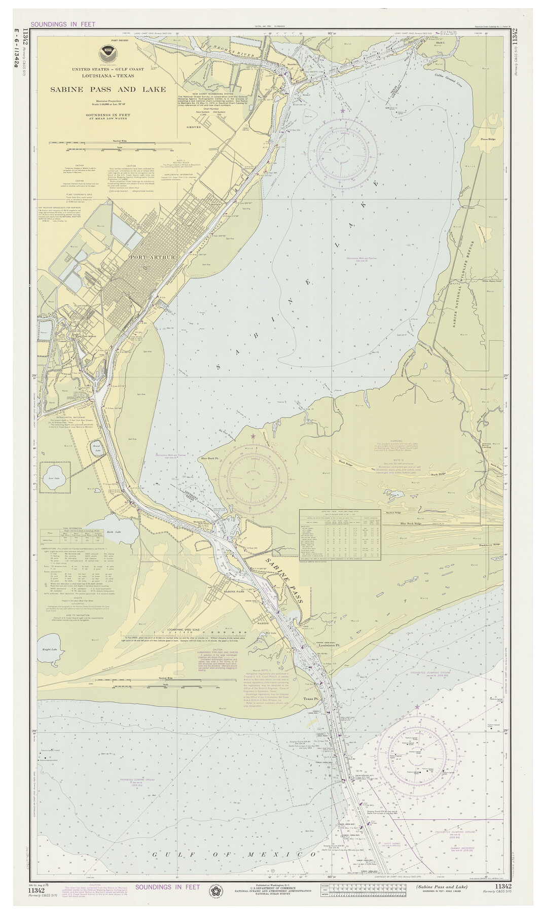
Sabine Pass and Lake
K-2-517a
-
Map/Doc
69827
-
Collection
General Map Collection
-
Object Dates
1975/8/2 (Creation Date)
-
Counties
Orange Jefferson
-
Subjects
Nautical Charts
-
Height x Width
46.9 x 27.8 inches
119.1 x 70.6 cm
Part of: General Map Collection
Flight Mission No. CLL-1N, Frame 29, Willacy County

Print $20.00
- Digital $50.00
Flight Mission No. CLL-1N, Frame 29, Willacy County
1954
Size 18.5 x 22.1 inches
Map/Doc 87010
Starr County Sketch File 36

Print $26.00
- Digital $50.00
Starr County Sketch File 36
1939
Size 14.3 x 8.7 inches
Map/Doc 36977
Flight Mission No. DIX-8P, Frame 63, Aransas County

Print $20.00
- Digital $50.00
Flight Mission No. DIX-8P, Frame 63, Aransas County
1956
Size 18.7 x 22.5 inches
Map/Doc 83894
Bell County Working Sketch 14

Print $20.00
- Digital $50.00
Bell County Working Sketch 14
1966
Size 38.7 x 30.8 inches
Map/Doc 67354
Flight Mission No. CLL-1N, Frame 31, Willacy County

Print $20.00
- Digital $50.00
Flight Mission No. CLL-1N, Frame 31, Willacy County
1954
Size 18.5 x 22.2 inches
Map/Doc 87012
Colorado River, Lane City Sheet

Print $4.00
- Digital $50.00
Colorado River, Lane City Sheet
1941
Size 27.0 x 29.9 inches
Map/Doc 65316
Flight Mission No. DAG-17K, Frame 138, Matagorda County

Print $20.00
- Digital $50.00
Flight Mission No. DAG-17K, Frame 138, Matagorda County
1952
Size 18.5 x 22.2 inches
Map/Doc 86355
Edwards County Working Sketch 98

Print $20.00
- Digital $50.00
Edwards County Working Sketch 98
1970
Size 35.1 x 37.6 inches
Map/Doc 68974
Flight Mission No. DAG-28K, Frame 28, Matagorda County

Print $20.00
- Digital $50.00
Flight Mission No. DAG-28K, Frame 28, Matagorda County
1953
Size 18.5 x 22.5 inches
Map/Doc 86596
Erath County Working Sketch 36

Print $20.00
- Digital $50.00
Erath County Working Sketch 36
1973
Size 33.5 x 30.4 inches
Map/Doc 69117
Presidio County Working Sketch 20

Print $20.00
- Digital $50.00
Presidio County Working Sketch 20
1943
Size 25.6 x 25.5 inches
Map/Doc 71696
Harris County Working Sketch 74

Print $20.00
- Digital $50.00
Harris County Working Sketch 74
1959
Size 25.7 x 30.0 inches
Map/Doc 65966
You may also like
Controlled Mosaic by Jack Amman Photogrammetric Engineers, Inc - Sheet 45

Print $20.00
- Digital $50.00
Controlled Mosaic by Jack Amman Photogrammetric Engineers, Inc - Sheet 45
1954
Size 20.0 x 24.0 inches
Map/Doc 83504
Childress County Sketch File 17a

Print $96.00
- Digital $50.00
Childress County Sketch File 17a
Size 12.4 x 8.6 inches
Map/Doc 18316
Right of Way and Track Map International & Gt. Northern Ry. operated by the International & Gt. Northern Ry. Co., Gulf Division, Columbia Branch

Print $40.00
- Digital $50.00
Right of Way and Track Map International & Gt. Northern Ry. operated by the International & Gt. Northern Ry. Co., Gulf Division, Columbia Branch
1917
Size 25.1 x 57.0 inches
Map/Doc 64600
Jefferson County Rolled Sketch 37

Print $20.00
- Digital $50.00
Jefferson County Rolled Sketch 37
1957
Size 36.4 x 30.1 inches
Map/Doc 6396
Current Miscellaneous File 95

Print $24.00
- Digital $50.00
Current Miscellaneous File 95
1994
Size 8.8 x 11.3 inches
Map/Doc 74270
Reagan County Working Sketch 14a

Print $20.00
- Digital $50.00
Reagan County Working Sketch 14a
1949
Size 25.9 x 15.2 inches
Map/Doc 71854
Delta County Working Sketch 2

Print $20.00
- Digital $50.00
Delta County Working Sketch 2
1963
Size 26.6 x 25.2 inches
Map/Doc 68639
Harrison County Working Sketch 34

Print $20.00
- Digital $50.00
Harrison County Working Sketch 34
2015
Size 13.7 x 17.9 inches
Map/Doc 93726
King County Sketch File 8

Print $46.00
- Digital $50.00
King County Sketch File 8
Size 8.8 x 8.9 inches
Map/Doc 29060
Plat of a portion of Buchel County, Texas

Print $20.00
- Digital $50.00
Plat of a portion of Buchel County, Texas
Size 16.0 x 26.2 inches
Map/Doc 82526
Aransas County Boundary File 1

Print $14.00
- Digital $50.00
Aransas County Boundary File 1
Size 14.2 x 8.6 inches
Map/Doc 49774
Starr County Rolled Sketch 38

Print $40.00
- Digital $50.00
Starr County Rolled Sketch 38
1944
Size 97.9 x 25.0 inches
Map/Doc 10297