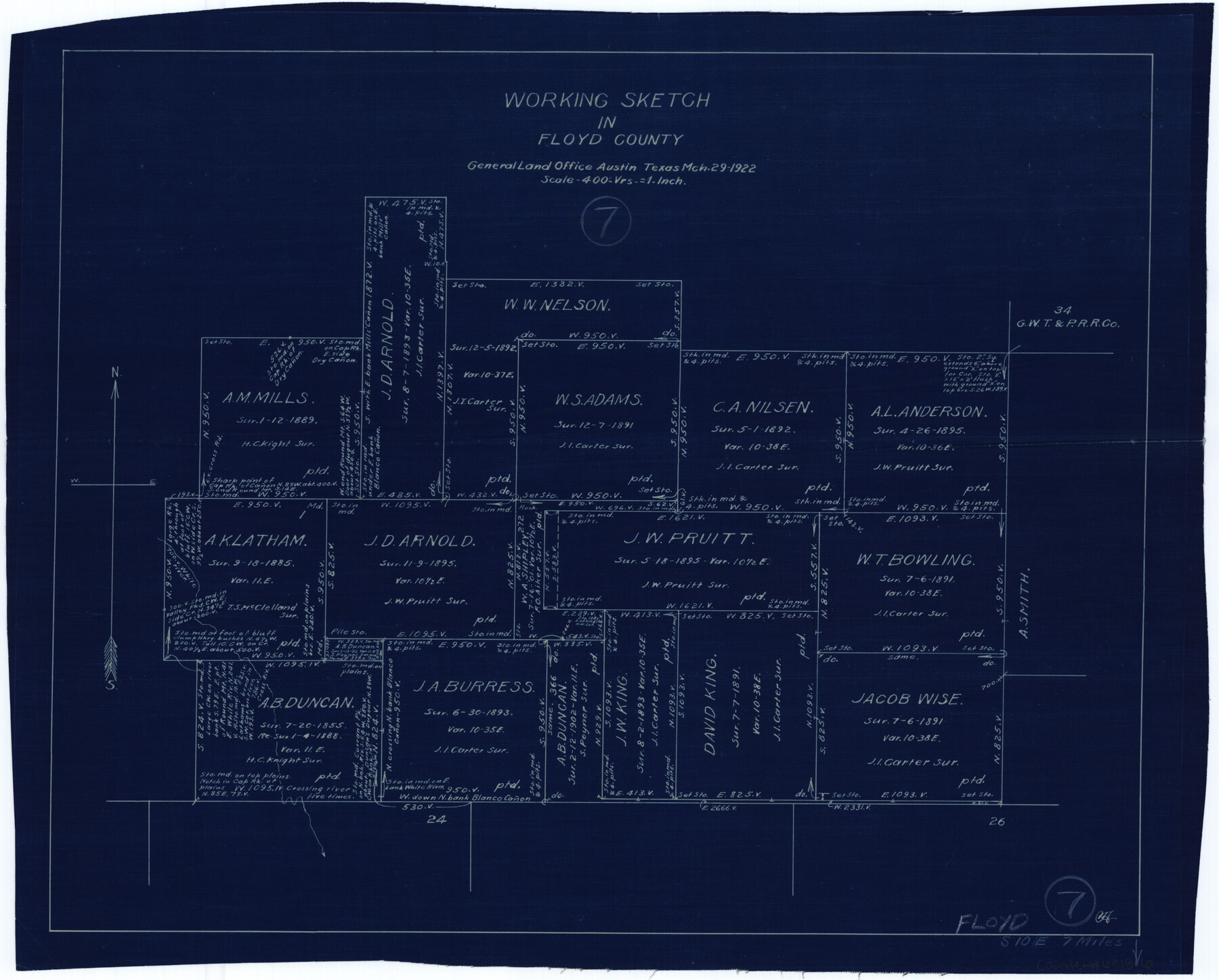
Floyd County Working Sketch 7
-
Map/Doc
69186
-
Collection
General Map Collection
-
Object Dates
3/29/1922 (Creation Date)
-
Counties
Floyd
-
Subjects
Surveying Working Sketch
-
Height x Width
14.4 x 17.9 inches
36.6 x 45.5 cm
-
Scale
1" = 400 varas
Part of: General Map Collection
Cherokee County Working Sketch 12

Print $20.00
- Digital $50.00
Cherokee County Working Sketch 12
1957
Size 36.6 x 46.0 inches
Map/Doc 67967
Flight Mission No. DAG-14K, Frame 134, Matagorda County

Print $20.00
- Digital $50.00
Flight Mission No. DAG-14K, Frame 134, Matagorda County
1952
Size 17.6 x 17.4 inches
Map/Doc 86305
Foard County Working Sketch 6

Print $20.00
- Digital $50.00
Foard County Working Sketch 6
1944
Size 43.4 x 31.4 inches
Map/Doc 69197
Williamson County Working Sketch 7

Print $20.00
- Digital $50.00
Williamson County Working Sketch 7
1949
Size 30.2 x 37.3 inches
Map/Doc 72567
Blanco County Boundary File 53

Print $50.00
- Digital $50.00
Blanco County Boundary File 53
Size 9.2 x 7.7 inches
Map/Doc 50580
Hardeman County

Print $20.00
- Digital $50.00
Hardeman County
1935
Size 46.0 x 42.7 inches
Map/Doc 95520
Lamb County Rolled Sketch 3

Print $20.00
- Digital $50.00
Lamb County Rolled Sketch 3
1917
Size 23.0 x 42.5 inches
Map/Doc 9413
Right of Way and Track Map, Texas & New Orleans R.R. Co. operated by the T. & N. O. R.R. Co., Dallas-Sabine Branch

Print $40.00
- Digital $50.00
Right of Way and Track Map, Texas & New Orleans R.R. Co. operated by the T. & N. O. R.R. Co., Dallas-Sabine Branch
1918
Size 24.6 x 56.4 inches
Map/Doc 64631
Hardeman County Working Sketch 11

Print $40.00
- Digital $50.00
Hardeman County Working Sketch 11
1960
Size 40.0 x 58.1 inches
Map/Doc 63392
Map of Wood County Showing Location of the Texas and Pacific Railway

Print $20.00
- Digital $50.00
Map of Wood County Showing Location of the Texas and Pacific Railway
1872
Size 19.1 x 23.8 inches
Map/Doc 64135
Donley County

Print $20.00
- Digital $50.00
Donley County
1944
Size 46.8 x 40.6 inches
Map/Doc 95484
The Texas Co-Ordinate System, Title 86 Art. 5300A

Print $20.00
- Digital $50.00
The Texas Co-Ordinate System, Title 86 Art. 5300A
1943
Size 27.7 x 30.3 inches
Map/Doc 3122
You may also like
Menard County Working Sketch 6

Print $20.00
- Digital $50.00
Menard County Working Sketch 6
1924
Size 24.4 x 15.3 inches
Map/Doc 70953
Gregg County Rolled Sketch TMB

Print $20.00
- Digital $50.00
Gregg County Rolled Sketch TMB
1931
Size 20.9 x 20.8 inches
Map/Doc 6042
Travis County Rolled Sketch 31

Print $20.00
- Digital $50.00
Travis County Rolled Sketch 31
1943
Size 43.4 x 27.3 inches
Map/Doc 8033
Panola County Working Sketch 31

Print $20.00
- Digital $50.00
Panola County Working Sketch 31
1981
Map/Doc 71440
La Salle County Sketch File 41

Print $20.00
- Digital $50.00
La Salle County Sketch File 41
1918
Size 25.8 x 15.9 inches
Map/Doc 11986
Mason County Sketch File 22

Print $8.00
- Digital $50.00
Mason County Sketch File 22
1932
Size 11.1 x 8.9 inches
Map/Doc 30719
[Map showing T&P Lands in El Paso County]
![88931, [Map showing T&P Lands in El Paso County], Library of Congress](https://historictexasmaps.com/wmedia_w700/maps/88931.tif.jpg)
Print $20.00
[Map showing T&P Lands in El Paso County]
Size 22.4 x 17.3 inches
Map/Doc 88931

Map showing the environs of Brazos Island, Texas

Print $20.00
- Digital $50.00
Map showing the environs of Brazos Island, Texas
Size 18.1 x 25.0 inches
Map/Doc 72926
[Folder for] Nautical Chart 11303: Texas Intracoastal Waterway, Laguna Madre, Chubby Island to Stover Point including the Arroyo Colorado
![75914, [Folder for] Nautical Chart 11303: Texas Intracoastal Waterway, Laguna Madre, Chubby Island to Stover Point including the Arroyo Colorado, General Map Collection](https://historictexasmaps.com/wmedia_w700/maps/75914-1.tif.jpg)
Print $20.00
- Digital $50.00
[Folder for] Nautical Chart 11303: Texas Intracoastal Waterway, Laguna Madre, Chubby Island to Stover Point including the Arroyo Colorado
1976
Size 15.9 x 18.8 inches
Map/Doc 75914
From Citizens Living in What Was to Become Fannin County for the Creation of a New County (Unnamed), Undated

Print $20.00
From Citizens Living in What Was to Become Fannin County for the Creation of a New County (Unnamed), Undated
2020
Size 17.6 x 21.7 inches
Map/Doc 96400
I No. 2 - Preliminary Sketch of Galveston Bay, Texas

Print $20.00
- Digital $50.00
I No. 2 - Preliminary Sketch of Galveston Bay, Texas
1852
Size 22.1 x 19.0 inches
Map/Doc 97227