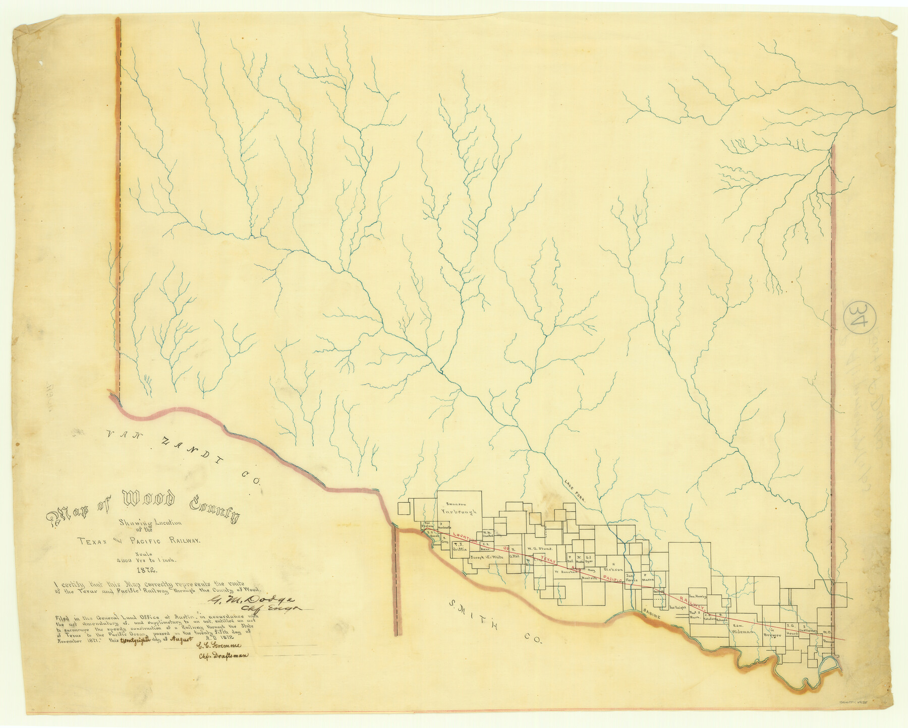
Map of Wood County Showing Location of the Texas and Pacific Railway
Z-2-34
-
Map/Doc
64135
-
Collection
General Map Collection
-
Object Dates
1872 (Creation Date)
1872/8/28 (File Date)
-
People and Organizations
G.M. Dodge (Surveyor/Engineer)
C. C. Stremme (Draftsman)
-
Counties
Wood
-
Subjects
Railroads
-
Height x Width
19.1 x 23.8 inches
48.5 x 60.5 cm
-
Medium
linen, manuscript
-
Scale
1" = 4000 varas
-
Comments
Adopted and conservation funded in 2006 by Dick and Cathy Roberts, Quitman, Texas.
See 64134 through 64139 for all sheets of this map. -
Features
T&P
Sabine River
Lake Fork [of Sabine River]
Part of: General Map Collection
Borden County Working Sketch 11

Print $40.00
- Digital $50.00
Borden County Working Sketch 11
1955
Size 51.6 x 26.5 inches
Map/Doc 67471
Hidalgo County Working Sketch 7

Print $40.00
- Digital $50.00
Hidalgo County Working Sketch 7
1963
Size 26.4 x 73.9 inches
Map/Doc 66184
Flight Mission No. DCL-7C, Frame 68, Kenedy County

Print $20.00
- Digital $50.00
Flight Mission No. DCL-7C, Frame 68, Kenedy County
1943
Size 15.3 x 15.2 inches
Map/Doc 86054
Knox County Rolled Sketch 24

Print $20.00
- Digital $50.00
Knox County Rolled Sketch 24
2007
Size 28.5 x 34.5 inches
Map/Doc 87722
Culberson County Rolled Sketch 14

Print $20.00
- Digital $50.00
Culberson County Rolled Sketch 14
1902
Size 35.3 x 34.6 inches
Map/Doc 8743
Wise County Sketch File 13

Print $4.00
- Digital $50.00
Wise County Sketch File 13
Size 9.0 x 15.2 inches
Map/Doc 40546
Nueces County Sketch File 61

Print $4.00
- Digital $50.00
Nueces County Sketch File 61
1930
Size 10.5 x 8.6 inches
Map/Doc 32969
Webb County Rolled Sketch 40

Print $20.00
- Digital $50.00
Webb County Rolled Sketch 40
1941
Size 20.6 x 18.4 inches
Map/Doc 8195
Hockley County

Print $20.00
- Digital $50.00
Hockley County
1900
Size 27.0 x 20.7 inches
Map/Doc 6215
Nueces County Rolled Sketch 119

Print $90.00
Nueces County Rolled Sketch 119
1994
Size 26.1 x 36.5 inches
Map/Doc 7151
Williamson County Sketch File 20

Print $4.00
- Digital $50.00
Williamson County Sketch File 20
Size 8.2 x 12.9 inches
Map/Doc 40348
Cass County Rolled Sketch 7

Print $20.00
- Digital $50.00
Cass County Rolled Sketch 7
1957
Size 28.3 x 33.5 inches
Map/Doc 5413
You may also like
Flight Mission No. BRA-8M, Frame 132, Jefferson County

Print $20.00
- Digital $50.00
Flight Mission No. BRA-8M, Frame 132, Jefferson County
1953
Size 18.7 x 22.3 inches
Map/Doc 85628
Refugio County Boundary File 4

Print $28.00
- Digital $50.00
Refugio County Boundary File 4
Size 14.0 x 8.8 inches
Map/Doc 58251
United States - Gulf Coast Texas - Southern part of Laguna Madre

Print $20.00
- Digital $50.00
United States - Gulf Coast Texas - Southern part of Laguna Madre
1941
Size 18.2 x 27.7 inches
Map/Doc 72947
The Republic County of Colorado. 1841

Print $20.00
The Republic County of Colorado. 1841
2020
Size 18.4 x 21.7 inches
Map/Doc 96123
Henderson County Boundary File 3

Print $32.00
- Digital $50.00
Henderson County Boundary File 3
Size 6.3 x 14.0 inches
Map/Doc 54669
Val Verde County Sketch File XX

Print $20.00
- Digital $50.00
Val Verde County Sketch File XX
Size 14.5 x 16.7 inches
Map/Doc 12546
Montague County Working Sketch 15

Print $20.00
- Digital $50.00
Montague County Working Sketch 15
1943
Size 15.7 x 12.2 inches
Map/Doc 71081
Floyd County Boundary File 2

Print $53.00
- Digital $50.00
Floyd County Boundary File 2
Size 8.9 x 4.2 inches
Map/Doc 53462
Wilbarger County Sketch File 13

Print $28.00
- Digital $50.00
Wilbarger County Sketch File 13
1885
Size 12.7 x 8.0 inches
Map/Doc 40189
[Sketch Showing L. Gonzales, Wm. H. McBee and adjacent surveys, Kaufman County, Texas]
![5071, [Sketch Showing L. Gonzales, Wm. H. McBee and adjacent surveys, Kaufman County, Texas], Maddox Collection](https://historictexasmaps.com/wmedia_w700/maps/5071.tif.jpg)
Print $20.00
- Digital $50.00
[Sketch Showing L. Gonzales, Wm. H. McBee and adjacent surveys, Kaufman County, Texas]
Size 23.2 x 19.8 inches
Map/Doc 5071
Ellis County Working Sketch 5

Print $40.00
- Digital $50.00
Ellis County Working Sketch 5
1997
Size 49.2 x 32.4 inches
Map/Doc 69021
Live Oak County Boundary File 60c

Print $4.00
- Digital $50.00
Live Oak County Boundary File 60c
Size 14.0 x 8.7 inches
Map/Doc 56421