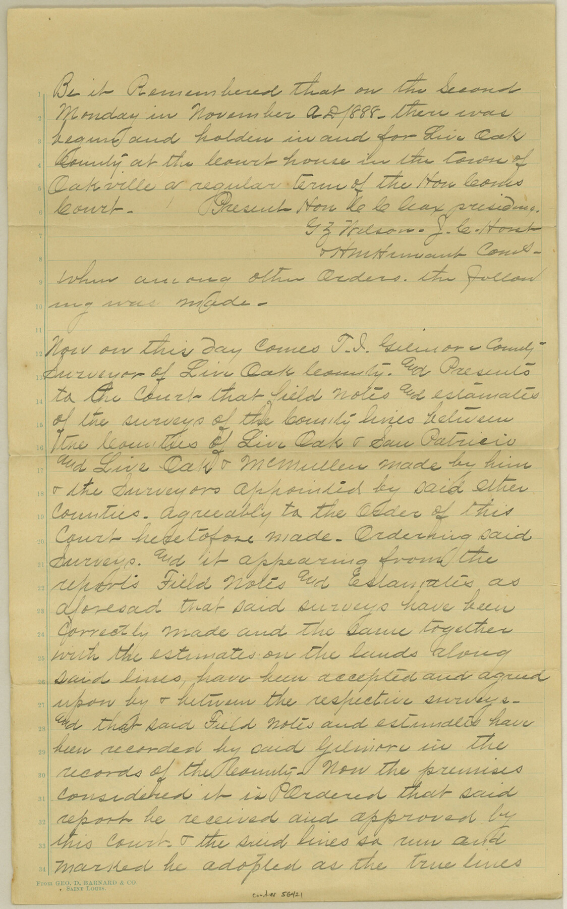
Live Oak County Boundary File 60c
[Court Order regarding Live Oak-San Patricio-McMullen Boundary line]
-
Map/Doc
56421
-
Collection
General Map Collection
-
Counties
Live Oak
-
Subjects
County Boundaries
-
Height x Width
14.0 x 8.7 inches
35.6 x 22.1 cm
Part of: General Map Collection
Hamilton County Sketch File 5

Print $4.00
- Digital $50.00
Hamilton County Sketch File 5
Size 10.2 x 8.1 inches
Map/Doc 24908
La Salle County Working Sketch 48

Print $20.00
- Digital $50.00
La Salle County Working Sketch 48
1983
Size 26.2 x 36.0 inches
Map/Doc 70349
Tyler County Working Sketch 2

Print $20.00
- Digital $50.00
Tyler County Working Sketch 2
1915
Size 17.5 x 10.4 inches
Map/Doc 69472
Old Miscellaneous File 33

Print $4.00
- Digital $50.00
Old Miscellaneous File 33
1874
Size 9.8 x 8.1 inches
Map/Doc 75753
Travis County Sketch File 39

Print $20.00
- Digital $50.00
Travis County Sketch File 39
1914
Size 15.5 x 25.7 inches
Map/Doc 12463
San Patricio County Working Sketch 22

Print $20.00
- Digital $50.00
San Patricio County Working Sketch 22
1981
Size 30.0 x 24.1 inches
Map/Doc 63784
[Surveys in Cherokee County]
![251, [Surveys in Cherokee County], General Map Collection](https://historictexasmaps.com/wmedia_w700/maps/251.tif.jpg)
Print $2.00
- Digital $50.00
[Surveys in Cherokee County]
Size 8.0 x 5.6 inches
Map/Doc 251
Wilbarger County Working Sketch 18

Print $20.00
- Digital $50.00
Wilbarger County Working Sketch 18
1965
Size 42.0 x 46.6 inches
Map/Doc 72556
Waller County Sketch File 6

Print $12.00
- Digital $50.00
Waller County Sketch File 6
Size 13.1 x 6.3 inches
Map/Doc 39602
Brewster County Rolled Sketch 155

Print $20.00
- Digital $50.00
Brewster County Rolled Sketch 155
Size 36.8 x 24.7 inches
Map/Doc 78343
Grayson County

Print $20.00
- Digital $50.00
Grayson County
1935
Size 45.9 x 41.2 inches
Map/Doc 1844
Flight Mission No. DQN-2K, Frame 32, Calhoun County

Print $20.00
- Digital $50.00
Flight Mission No. DQN-2K, Frame 32, Calhoun County
1953
Size 18.7 x 22.3 inches
Map/Doc 84239
You may also like
Angelina County Sketch File 18a

Print $5.00
- Digital $50.00
Angelina County Sketch File 18a
Size 7.7 x 12.0 inches
Map/Doc 13030
Coleman County Sketch File 4a

Print $20.00
- Digital $50.00
Coleman County Sketch File 4a
1873
Size 12.4 x 20.9 inches
Map/Doc 11118
La Salle County Rolled Sketch 16

Print $20.00
- Digital $50.00
La Salle County Rolled Sketch 16
1948
Size 26.7 x 20.9 inches
Map/Doc 6580
Tarrant County Sketch File 29

Print $4.00
- Digital $50.00
Tarrant County Sketch File 29
1879
Size 7.9 x 11.6 inches
Map/Doc 37745
Childress County

Print $20.00
- Digital $50.00
Childress County
1883
Size 20.6 x 17.4 inches
Map/Doc 3393
Map of Comal County

Print $20.00
- Digital $50.00
Map of Comal County
1897
Size 40.4 x 46.3 inches
Map/Doc 4917
Section IX, Galveston Harbor and Bar

Print $20.00
- Digital $50.00
Section IX, Galveston Harbor and Bar
1850
Size 30.0 x 45.7 inches
Map/Doc 69855
Webb County Working Sketch 90

Print $20.00
- Digital $50.00
Webb County Working Sketch 90
1982
Size 26.9 x 25.5 inches
Map/Doc 72457
Chambers County NRC Article 33.136 Sketch 7

Print $28.00
- Digital $50.00
Chambers County NRC Article 33.136 Sketch 7
2011
Size 18.0 x 24.0 inches
Map/Doc 94753
Palo Pinto County Working Sketch 2

Print $20.00
- Digital $50.00
Palo Pinto County Working Sketch 2
1906
Size 15.2 x 46.2 inches
Map/Doc 71385
Midland County Sketch File 18

Print $4.00
- Digital $50.00
Midland County Sketch File 18
Size 14.7 x 8.1 inches
Map/Doc 31585
Padre Island National Seashore

Print $4.00
- Digital $50.00
Padre Island National Seashore
Size 16.1 x 22.1 inches
Map/Doc 60531