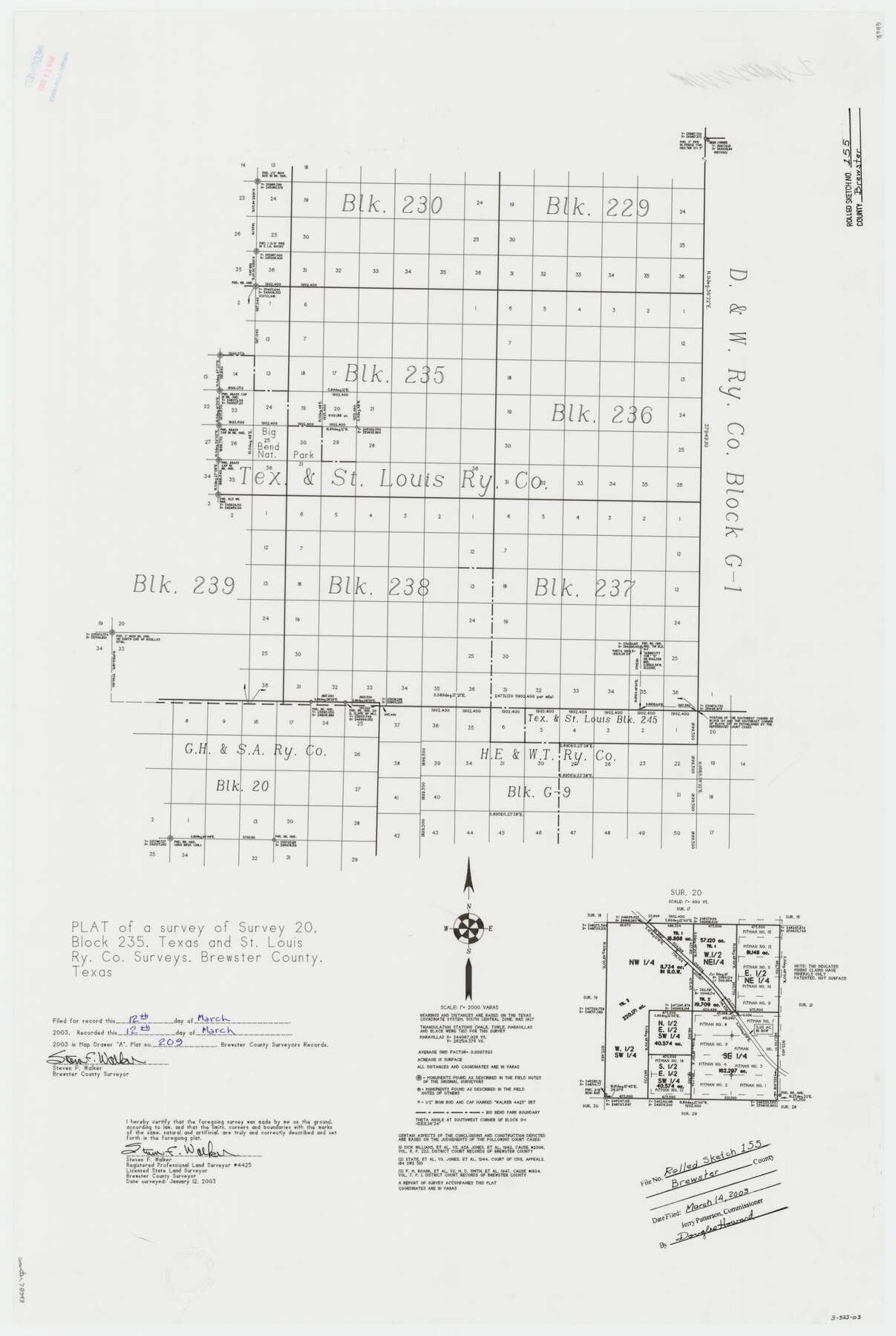
Brewster County Rolled Sketch 155
Plat of a survey of survey 20, Block 235, Texas and St. Louis Ry. Co.
-
Map/Doc
78343
-
Collection
General Map Collection
-
Object Dates
2003/1/12 (Survey Date)
2003/3/14 (File Date)
-
People and Organizations
Steven F. Walker (Surveyor/Engineer)
-
Counties
Brewster
-
Subjects
Surveying Rolled Sketch
-
Height x Width
36.8 x 24.7 inches
93.5 x 62.7 cm
-
Medium
mylar, print
-
Scale
1" = 2000 varas
Part of: General Map Collection
Bee County Working Sketch 22

Print $20.00
- Digital $50.00
Bee County Working Sketch 22
1983
Size 37.9 x 37.2 inches
Map/Doc 67272
Flight Mission No. BQR-20K, Frame 6, Brazoria County

Print $20.00
- Digital $50.00
Flight Mission No. BQR-20K, Frame 6, Brazoria County
1952
Size 18.6 x 22.3 inches
Map/Doc 84108
Harris County Rolled Sketch 45

Print $20.00
- Digital $50.00
Harris County Rolled Sketch 45
Size 20.2 x 21.0 inches
Map/Doc 6103
Flight Mission No. DQN-2K, Frame 74, Calhoun County

Print $20.00
- Digital $50.00
Flight Mission No. DQN-2K, Frame 74, Calhoun County
1953
Size 18.6 x 22.2 inches
Map/Doc 84266
Oldham County Sketch File 16

Print $6.00
- Digital $50.00
Oldham County Sketch File 16
1904
Size 11.2 x 8.8 inches
Map/Doc 33264

Fractional Township No. 8 South Range No. 1 West of the Indian Meridian, Indian Territory

Print $20.00
- Digital $50.00
Fractional Township No. 8 South Range No. 1 West of the Indian Meridian, Indian Territory
1898
Size 19.2 x 24.4 inches
Map/Doc 75198
Flight Mission No. DQN-7K, Frame 94, Calhoun County

Print $20.00
- Digital $50.00
Flight Mission No. DQN-7K, Frame 94, Calhoun County
1953
Size 18.6 x 22.1 inches
Map/Doc 84485

Edwards County Working Sketch 35

Print $20.00
- Digital $50.00
Edwards County Working Sketch 35
1948
Size 20.9 x 31.1 inches
Map/Doc 68911
McMullen County Working Sketch 15

Print $20.00
- Digital $50.00
McMullen County Working Sketch 15
1939
Size 18.4 x 27.5 inches
Map/Doc 70716
Coke County Sketch File 23

Print $20.00
- Digital $50.00
Coke County Sketch File 23
Size 43.9 x 18.5 inches
Map/Doc 10338
You may also like
Ochiltree County Rolled Sketch 2

Print $20.00
- Digital $50.00
Ochiltree County Rolled Sketch 2
Size 23.0 x 17.7 inches
Map/Doc 7172
Reeves County Working Sketch 45

Print $20.00
- Digital $50.00
Reeves County Working Sketch 45
1974
Size 46.9 x 32.3 inches
Map/Doc 63488
Map of Escarpment Section through Jim Hogg County

Print $40.00
- Digital $50.00
Map of Escarpment Section through Jim Hogg County
1925
Size 43.3 x 88.7 inches
Map/Doc 93158
Castro County Working Sketch 6

Print $20.00
- Digital $50.00
Castro County Working Sketch 6
1975
Size 28.4 x 26.4 inches
Map/Doc 67901
Brazoria County Sketch File 32

Print $60.00
- Digital $50.00
Brazoria County Sketch File 32
1896
Size 14.1 x 16.2 inches
Map/Doc 10955
Jefferson County Working Sketch 14

Print $20.00
- Digital $50.00
Jefferson County Working Sketch 14
1948
Size 30.3 x 25.8 inches
Map/Doc 66557
Map of the Lands Surveyed by the Memphis, El Paso & Pacific R.R. Company

Print $20.00
- Digital $50.00
Map of the Lands Surveyed by the Memphis, El Paso & Pacific R.R. Company
1859
Size 15.0 x 30.0 inches
Map/Doc 2219
Lampasas County Rolled Sketch 2

Print $20.00
- Digital $50.00
Lampasas County Rolled Sketch 2
Size 21.0 x 39.2 inches
Map/Doc 6565
Morris County Rolled Sketch 2A

Print $20.00
- Digital $50.00
Morris County Rolled Sketch 2A
Size 24.0 x 18.6 inches
Map/Doc 10235
Hydrography Survey H-6395 Off Coast of Texas, Aransas Pass to Corpus Christi Pass in the Gulf of Mexico

Print $40.00
- Digital $50.00
Hydrography Survey H-6395 Off Coast of Texas, Aransas Pass to Corpus Christi Pass in the Gulf of Mexico
1938
Size 56.1 x 33.6 inches
Map/Doc 2696
Amistad International Reservoir on Rio Grande 65

Print $20.00
- Digital $50.00
Amistad International Reservoir on Rio Grande 65
1949
Size 28.2 x 39.8 inches
Map/Doc 73350
Van Zandt County

Print $20.00
- Digital $50.00
Van Zandt County
1870
Size 22.8 x 21.1 inches
Map/Doc 4638