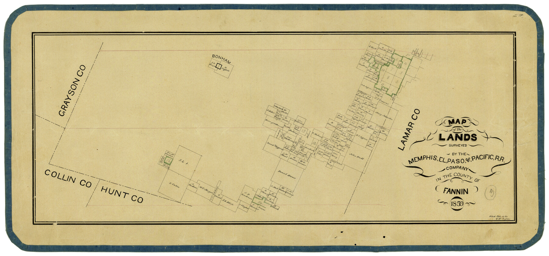
Map of the Lands Surveyed by the Memphis, El Paso & Pacific R.R. Company
T-1-12
- 
                          Map/Doc2219
- 
                            CollectionGeneral Map Collection
- 
                            Object Dates1859 (Creation Date)
- 
                            CountiesFannin
- 
                            SubjectsRailroads
- 
                            Height x Width15.0 x 30.0 inches38.1 x 76.2 cm
- 
                            CommentsBecame Texas and Pacific Railway Company in 1873.
 Adopted with contributions from the State Employee Charitable Campaign (SECC) and conservation funded in 2011.
Part of: General Map Collection
            Pecos County Working Sketch 135


                                            Print $20.00                    
                                             -                         Digital $50.00                                    
                Pecos County Working Sketch 135
1979
Size 46.4 x 37.3 inches
                                Map/Doc 71609
            
            Flight Mission No. DQO-7K, Frame 103, Galveston County


                                            Print $20.00                    
                                             -                         Digital $50.00                                    
                Flight Mission No. DQO-7K, Frame 103, Galveston County
1952
Size 18.5 x 22.7 inches
                                Map/Doc 85118
            
            Wilbarger County Working Sketch 14


                                            Print $20.00                    
                                             -                         Digital $50.00                                    
                Wilbarger County Working Sketch 14
1955
Size 24.8 x 21.7 inches
                                Map/Doc 72552
            
            Coke County Boundary File 5


                                            Print $36.00                    
                                             -                         Digital $50.00                                    
                Coke County Boundary File 5
Size 7.7 x 37.9 inches
                                Map/Doc 51606
            
            Natural Heritage of Texas


                                            Print $40.00                    
                                             -                         Digital $50.00                                    
                Natural Heritage of Texas
1986
Size 54.3 x 56.0 inches
                                Map/Doc 10786
            
            Dimmit County Working Sketch 29


                                            Print $40.00                    
                                             -                         Digital $50.00                                    
                Dimmit County Working Sketch 29
1957
Size 58.1 x 36.2 inches
                                Map/Doc 68690
            
            Travis County


                                            Print $40.00                    
                                             -                         Digital $50.00                                    
                Travis County
1880
Size 59.0 x 70.2 inches
                                Map/Doc 16902
            
            Coleman County Sketch File 15


                                            Print $4.00                    
                                             -                         Digital $50.00                                    
                Coleman County Sketch File 15
1848
Size 7.3 x 13.0 inches
                                Map/Doc 18681
            
            Map of the Country upon the Brazos and Big Witchita Rivers Explored in 1854 by Capt. R.B. Marcy 5th U.S. Infy. Embracing the Lands appropriated by the State of Texas for the Use of the Indians


                                            Print $20.00                    
                                             -                         Digital $50.00                                    
                Map of the Country upon the Brazos and Big Witchita Rivers Explored in 1854 by Capt. R.B. Marcy 5th U.S. Infy. Embracing the Lands appropriated by the State of Texas for the Use of the Indians
Size 29.6 x 33.8 inches
                                Map/Doc 93999
            
            Kinney County Working Sketch 40


                                            Print $20.00                    
                                             -                         Digital $50.00                                    
                Kinney County Working Sketch 40
1972
Size 30.7 x 34.1 inches
                                Map/Doc 70222
            You may also like
            Reeves County Rolled Sketch 40


                                            Print $20.00                    
                                             -                         Digital $50.00                                    
                Reeves County Rolled Sketch 40
2019
Size 18.1 x 24.2 inches
                                Map/Doc 95826
            
            Flight Mission No. CGI-3N, Frame 161, Cameron County


                                            Print $20.00                    
                                             -                         Digital $50.00                                    
                Flight Mission No. CGI-3N, Frame 161, Cameron County
1954
Size 18.7 x 22.4 inches
                                Map/Doc 84625
            
            Stonewall County Boundary File 1


                                            Print $34.00                    
                                             -                         Digital $50.00                                    
                Stonewall County Boundary File 1
Size 9.0 x 8.4 inches
                                Map/Doc 58938
            
            Rand McNally Standard Map of Texas


                                            Print $20.00                    
                                             -                         Digital $50.00                                    
                Rand McNally Standard Map of Texas
1926
Size 27.3 x 39.9 inches
                                Map/Doc 95855
            
            Red River, Bois D'Arc Creek Floodway Sheet No. 6


                                            Print $20.00                    
                                             -                         Digital $50.00                                    
                Red River, Bois D'Arc Creek Floodway Sheet No. 6
1917
Size 28.9 x 23.4 inches
                                Map/Doc 69661
            
            McMullen County Rolled Sketch 9


                                            Print $20.00                    
                                             -                         Digital $50.00                                    
                McMullen County Rolled Sketch 9
Size 34.4 x 40.9 inches
                                Map/Doc 6726
            
            Carson County Boundary File 7


                                            Print $64.00                    
                                             -                         Digital $50.00                                    
                Carson County Boundary File 7
Size 9.3 x 6.9 inches
                                Map/Doc 51157
            
            Refugio County Sketch File 16


                                            Print $4.00                    
                                             -                         Digital $50.00                                    
                Refugio County Sketch File 16
Size 7.1 x 8.2 inches
                                Map/Doc 35270
            
            Coast Chart No. 210 Aransas Pass and Corpus Christi Bay with the coast to latitude 27° 12' Texas


                                            Print $20.00                    
                                             -                         Digital $50.00                                    
                Coast Chart No. 210 Aransas Pass and Corpus Christi Bay with the coast to latitude 27° 12' Texas
1887
Size 27.6 x 18.3 inches
                                Map/Doc 72790
            
            Map of Texas to Accompany Granger's Southern and Western Texas Guide


                                            Print $20.00                    
                                    
                Map of Texas to Accompany Granger's Southern and Western Texas Guide
1878
Size 26.4 x 20.4 inches
                                Map/Doc 76235
            
            Knox County Sketch File 10


                                            Print $20.00                    
                                             -                         Digital $50.00                                    
                Knox County Sketch File 10
1889
Size 20.1 x 12.8 inches
                                Map/Doc 11958
            
            Township No. 1 South Range No. 25 West of the Indian Meridian


                                            Print $20.00                    
                                             -                         Digital $50.00                                    
                Township No. 1 South Range No. 25 West of the Indian Meridian
1875
Size 19.2 x 24.3 inches
                                Map/Doc 75248
             
                         
                                