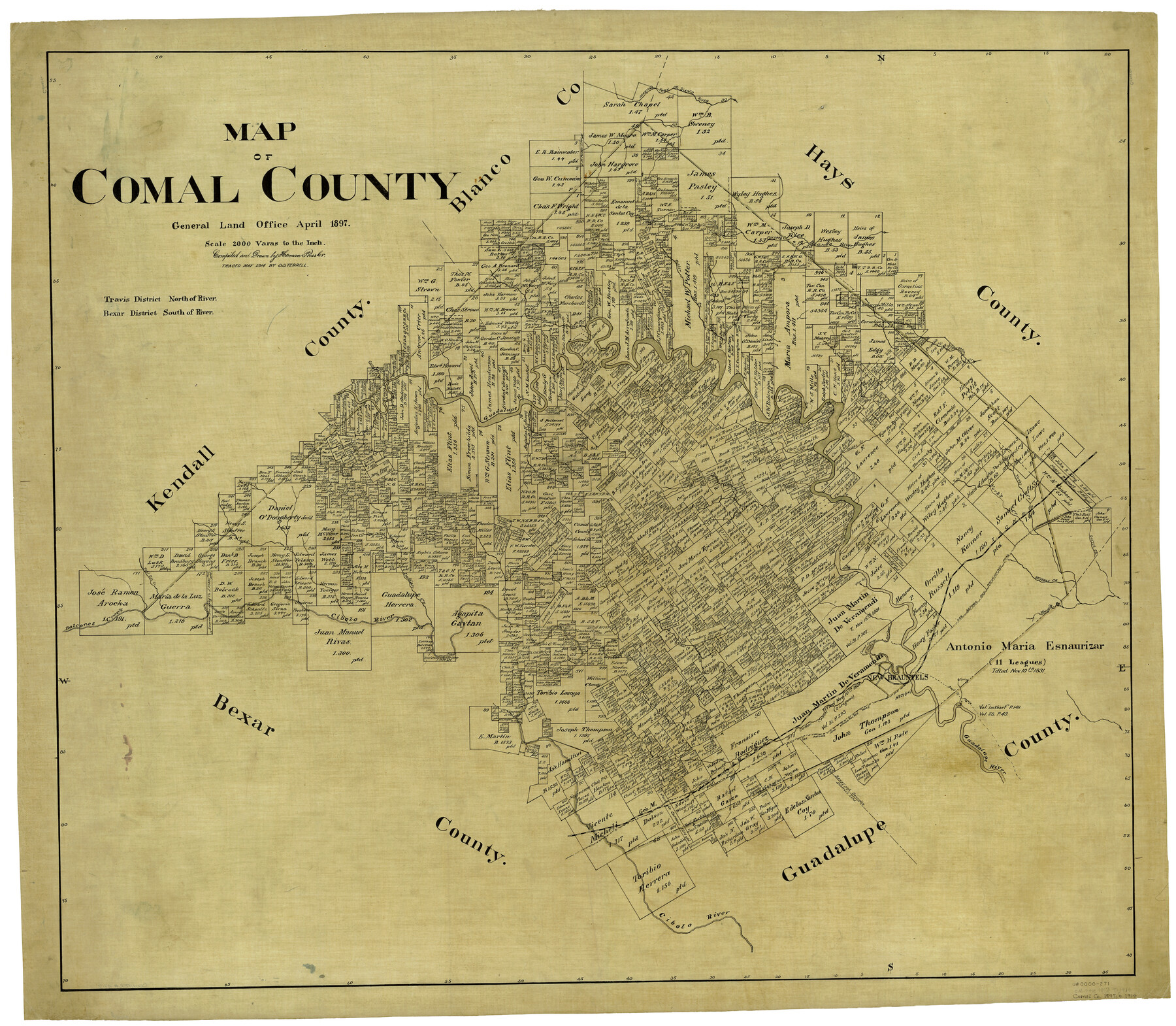
Map of Comal County
-
Map/Doc
4917
-
Collection
General Map Collection
-
Object Dates
4/1897 (Creation Date)
5/1914 (Tracing Date)
-
People and Organizations
Herman Pressler (Draftsman)
O.O. Terrell (Tracer)
-
Counties
Comal
-
Subjects
County
-
Height x Width
40.4 x 46.3 inches
102.6 x 117.6 cm
Part of: General Map Collection
Ector County Rolled Sketch 14

Print $20.00
- Digital $50.00
Ector County Rolled Sketch 14
1957
Size 38.0 x 31.3 inches
Map/Doc 5779
Ile de la Réunion, Colonie Française (Océan indien)

Print $20.00
- Digital $50.00
Ile de la Réunion, Colonie Française (Océan indien)
Size 14.5 x 20.5 inches
Map/Doc 94451

Flight Mission No. CGI-3N, Frame 79, Cameron County

Print $20.00
- Digital $50.00
Flight Mission No. CGI-3N, Frame 79, Cameron County
1954
Size 18.6 x 22.4 inches
Map/Doc 84573
Kerr County Rolled Sketch 19

Print $20.00
- Digital $50.00
Kerr County Rolled Sketch 19
1954
Size 43.4 x 28.4 inches
Map/Doc 6501
Newton County Rolled Sketch 27A
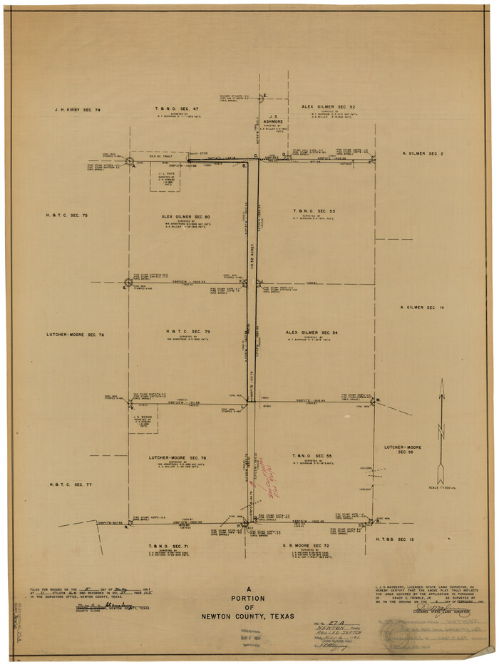
Print $20.00
- Digital $50.00
Newton County Rolled Sketch 27A
1961
Size 35.9 x 27.1 inches
Map/Doc 6857
Briscoe County Sketch File L

Print $40.00
- Digital $50.00
Briscoe County Sketch File L
1935
Size 30.4 x 27.4 inches
Map/Doc 11009
Gregg County Rolled Sketch 9A

Print $20.00
- Digital $50.00
Gregg County Rolled Sketch 9A
1932
Size 38.1 x 30.2 inches
Map/Doc 6035
Hood County Sketch File 7

Print $6.00
- Digital $50.00
Hood County Sketch File 7
Size 12.9 x 7.9 inches
Map/Doc 26581
Topographical Map of the Rio Grande, Sheet No. 11

Print $20.00
- Digital $50.00
Topographical Map of the Rio Grande, Sheet No. 11
1912
Map/Doc 89535
Greater Austin, Texas Streetmap

Greater Austin, Texas Streetmap
Size 46.1 x 36.3 inches
Map/Doc 94430
Flight Mission No. BQR-4K, Frame 67, Brazoria County

Print $20.00
- Digital $50.00
Flight Mission No. BQR-4K, Frame 67, Brazoria County
1952
Size 18.7 x 22.5 inches
Map/Doc 84000
You may also like
Webb County Sketch File 12-2

Print $20.00
- Digital $50.00
Webb County Sketch File 12-2
1936
Size 24.5 x 20.1 inches
Map/Doc 12630
Brazoria County Sketch File 12

Print $8.00
- Digital $50.00
Brazoria County Sketch File 12
1886
Size 12.8 x 8.2 inches
Map/Doc 14967
Brewster County Working Sketch 39

Print $20.00
- Digital $50.00
Brewster County Working Sketch 39
1944
Size 26.8 x 37.5 inches
Map/Doc 67573
Texas City Heights being a subdivision of the east half of the Robert Logan one third league, Galveston County, Texas

Print $20.00
- Digital $50.00
Texas City Heights being a subdivision of the east half of the Robert Logan one third league, Galveston County, Texas
1895
Size 22.4 x 17.3 inches
Map/Doc 95356
Ward County Working Sketch 33

Print $20.00
- Digital $50.00
Ward County Working Sketch 33
1968
Size 26.3 x 32.3 inches
Map/Doc 72339
Runnels County Rolled Sketch 18

Print $20.00
- Digital $50.00
Runnels County Rolled Sketch 18
Size 23.1 x 25.3 inches
Map/Doc 7513
Kaufman County Working Sketch 7

Print $20.00
- Digital $50.00
Kaufman County Working Sketch 7
1984
Size 33.6 x 35.5 inches
Map/Doc 66670
Cottle County Rolled Sketch D

Print $20.00
- Digital $50.00
Cottle County Rolled Sketch D
1898
Size 29.0 x 20.4 inches
Map/Doc 5572
La Salle County Rolled Sketch 15

Print $20.00
- Digital $50.00
La Salle County Rolled Sketch 15
Size 22.0 x 32.4 inches
Map/Doc 6579
Baylor County Working Sketch 4

Print $20.00
- Digital $50.00
Baylor County Working Sketch 4
1938
Size 30.4 x 21.0 inches
Map/Doc 67289
Crosby County Sketch File 15a

Print $20.00
- Digital $50.00
Crosby County Sketch File 15a
1907
Size 37.6 x 41.1 inches
Map/Doc 10352
[In Northwest 1/4 of County in the vicinity of the John Walker Survey]
![90903, [In Northwest 1/4 of County in the vicinity of the John Walker Survey], Twichell Survey Records](https://historictexasmaps.com/wmedia_w700/maps/90903-1.tif.jpg)
Print $2.00
- Digital $50.00
[In Northwest 1/4 of County in the vicinity of the John Walker Survey]
Size 7.3 x 15.3 inches
Map/Doc 90903