Old Miscellaneous File 33
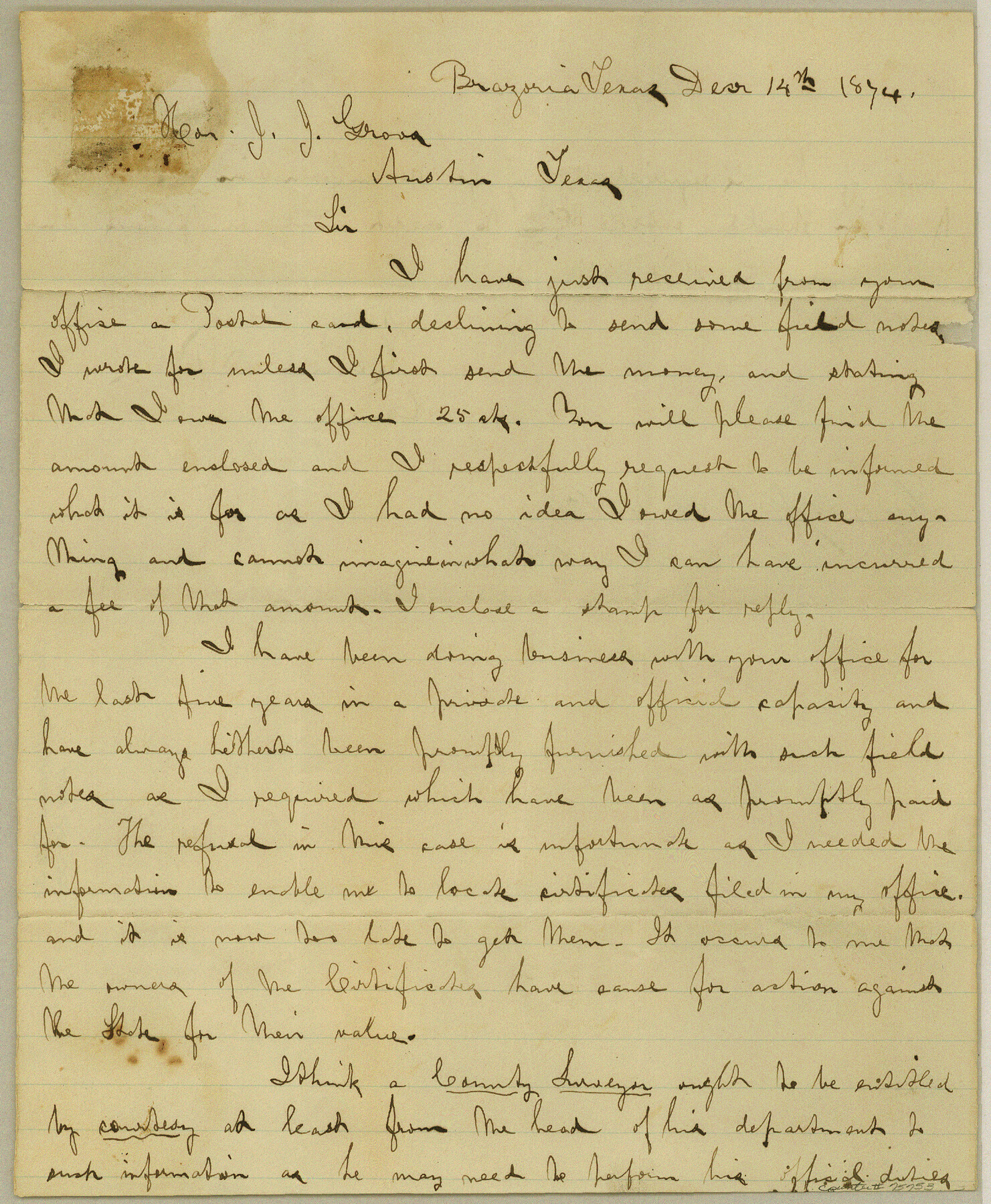
Letter from County Surveyor of Brazoria County requesting field notes
-
Map/Doc
75753
-
Collection
General Map Collection
-
Object Dates
1874/12/14 (Creation Date)
1985/2/8 (File Date)
-
People and Organizations
Hennell Stevens (Author)
-
Subjects
Curiosities
-
Height x Width
9.8 x 8.1 inches
24.9 x 20.6 cm
Part of: General Map Collection
Ochiltree County Boundary File 5

Print $54.00
- Digital $50.00
Ochiltree County Boundary File 5
Size 9.3 x 8.3 inches
Map/Doc 57684
Moore County Rolled Sketch 14

Print $20.00
- Digital $50.00
Moore County Rolled Sketch 14
1981
Size 22.6 x 26.6 inches
Map/Doc 6830
Nueces County Rolled Sketch 51A

Print $20.00
- Digital $50.00
Nueces County Rolled Sketch 51A
1978
Size 27.6 x 39.1 inches
Map/Doc 6890
Flight Mission No. DAG-22K, Frame 81, Matagorda County

Print $20.00
- Digital $50.00
Flight Mission No. DAG-22K, Frame 81, Matagorda County
1953
Size 18.6 x 22.4 inches
Map/Doc 86465
Falls County Sketch File 16

Print $8.00
- Digital $50.00
Falls County Sketch File 16
Size 13.3 x 8.5 inches
Map/Doc 22374

Houston County Sketch File 19

Print $4.00
- Digital $50.00
Houston County Sketch File 19
1851
Size 12.8 x 8.3 inches
Map/Doc 26785
Travis County Sketch File 41

Print $22.00
- Digital $50.00
Travis County Sketch File 41
1928
Size 11.7 x 30.2 inches
Map/Doc 12465
Index sheet to accompany map of survey for connecting the inland waters along margin of the Gulf of Mexico from Donaldsonville in Louisiana to the Rio Grande River in Texas

Print $20.00
- Digital $50.00
Index sheet to accompany map of survey for connecting the inland waters along margin of the Gulf of Mexico from Donaldsonville in Louisiana to the Rio Grande River in Texas
1874
Size 18.2 x 27.1 inches
Map/Doc 72696
Terrell County Working Sketch 68

Print $20.00
- Digital $50.00
Terrell County Working Sketch 68
1973
Size 43.7 x 26.4 inches
Map/Doc 69589
Polk County Working Sketch 6

Print $20.00
- Digital $50.00
Polk County Working Sketch 6
1933
Size 22.8 x 32.7 inches
Map/Doc 71621
Motley County Working Sketch 6

Print $20.00
- Digital $50.00
Motley County Working Sketch 6
1963
Size 17.6 x 29.3 inches
Map/Doc 71211
You may also like
Travis County Boundary File 6

Print $109.00
- Digital $50.00
Travis County Boundary File 6
Size 14.6 x 9.1 inches
Map/Doc 59433
Terry County Rolled Sketch 8

Print $20.00
- Digital $50.00
Terry County Rolled Sketch 8
Size 31.7 x 22.3 inches
Map/Doc 7982
University Land Loving-Ward-Winkler Counties

Print $40.00
- Digital $50.00
University Land Loving-Ward-Winkler Counties
1931
Size 47.9 x 63.2 inches
Map/Doc 2415
Stonewall County Rolled Sketch 18

Print $20.00
- Digital $50.00
Stonewall County Rolled Sketch 18
1950
Size 27.4 x 29.4 inches
Map/Doc 7872
[Atlas D, Table of Contents]
![78350, [Atlas D, Table of Contents], General Map Collection](https://historictexasmaps.com/wmedia_w700/maps/78350.tif.jpg)
Print $20.00
- Digital $50.00
[Atlas D, Table of Contents]
Size 18.3 x 9.5 inches
Map/Doc 78350
San Jacinto County Rolled Sketch 3

Print $40.00
- Digital $50.00
San Jacinto County Rolled Sketch 3
Size 24.4 x 59.4 inches
Map/Doc 9880
Hood County Sketch File 20

Print $4.00
- Digital $50.00
Hood County Sketch File 20
1873
Size 6.8 x 6.9 inches
Map/Doc 26607
Flight Mission No. BRA-16M, Frame 71, Jefferson County

Print $20.00
- Digital $50.00
Flight Mission No. BRA-16M, Frame 71, Jefferson County
1953
Size 18.7 x 22.3 inches
Map/Doc 85688
[Tom Green County]
![16901, [Tom Green County], General Map Collection](https://historictexasmaps.com/wmedia_w700/maps/16901.tif.jpg)
Print $20.00
- Digital $50.00
[Tom Green County]
1888
Size 33.2 x 34.4 inches
Map/Doc 16901
Hutchinson County Rolled Sketch 4

Print $20.00
- Digital $50.00
Hutchinson County Rolled Sketch 4
Size 21.3 x 30.1 inches
Map/Doc 6277
Hemphill County Rolled Sketch 13

Print $20.00
- Digital $50.00
Hemphill County Rolled Sketch 13
1905
Size 20.7 x 28.9 inches
Map/Doc 6193
Ellwood Farms Subdivision Number 2 of the Spade Ranch Lamb and Hale Counties, Texas

Print $20.00
- Digital $50.00
Ellwood Farms Subdivision Number 2 of the Spade Ranch Lamb and Hale Counties, Texas
Size 20.9 x 29.1 inches
Map/Doc 92173