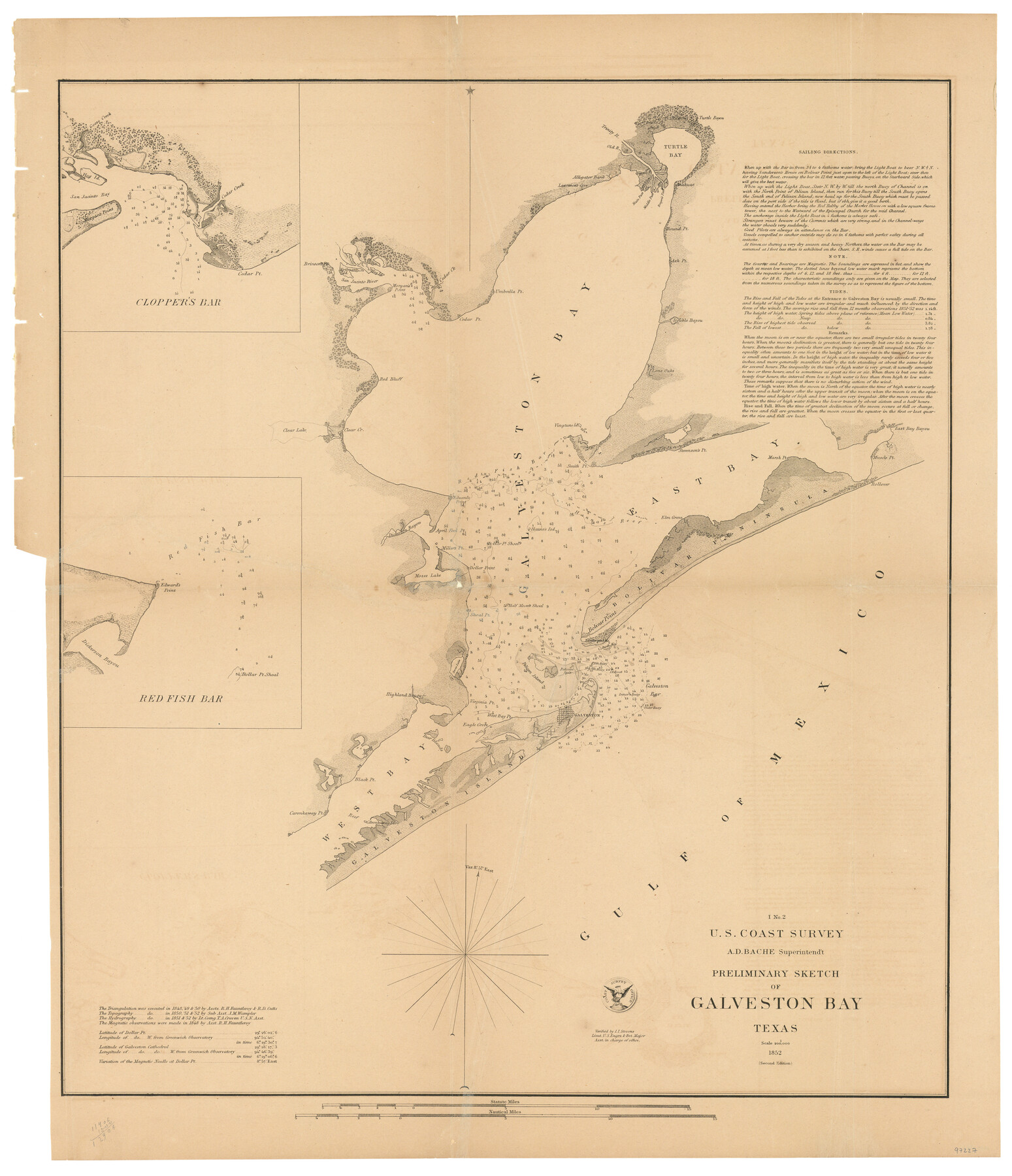
I No. 2 - Preliminary Sketch of Galveston Bay, Texas
-
Map/Doc
97227
-
Collection
General Map Collection
-
Object Dates
1852 (Creation Date)
-
People and Organizations
A.D. Bache (Superintendent)
I.I. Stevens (Surveyor/Engineer)
U.S. Coast Survey (Publisher)
-
Subjects
Coastal
-
Height x Width
22.1 x 19.0 inches
56.1 x 48.3 cm
-
Comments
Sketch from the book "Report of the Superintendent of the Coast Survey Showing the Progress of the Survey in the year 1852" (81738)
Related maps
Report of the Superintendent of the Coast Survey showing the progress of the survey during the year 1852

Report of the Superintendent of the Coast Survey showing the progress of the survey during the year 1852
1853
Map/Doc 81738
Part of: General Map Collection
Cottle County Sketch File 6a

Print $8.00
- Digital $50.00
Cottle County Sketch File 6a
Size 8.6 x 7.3 inches
Map/Doc 19476
Copy of a portion of Arista's map

Print $20.00
- Digital $50.00
Copy of a portion of Arista's map
1847
Size 27.5 x 18.3 inches
Map/Doc 73057
Atascosa County Rolled Sketch 22

Print $40.00
- Digital $50.00
Atascosa County Rolled Sketch 22
1917
Size 26.5 x 57.2 inches
Map/Doc 8922
Hunt County Working Sketch 2

Print $20.00
- Digital $50.00
Hunt County Working Sketch 2
Size 20.5 x 16.5 inches
Map/Doc 66349
Wood County Sketch File 6

Print $8.00
- Digital $50.00
Wood County Sketch File 6
1877
Size 8.2 x 5.4 inches
Map/Doc 40641
Atascosa County Working Sketch 15

Print $40.00
- Digital $50.00
Atascosa County Working Sketch 15
1935
Size 43.8 x 53.6 inches
Map/Doc 67211
Map of section no. 7 of a survey of Padre Island made for the Office of the Attorney General of the State of Texas

Print $40.00
- Digital $50.00
Map of section no. 7 of a survey of Padre Island made for the Office of the Attorney General of the State of Texas
1941
Size 56.3 x 41.2 inches
Map/Doc 2263
Eastland County Working Sketch 43

Print $20.00
- Digital $50.00
Eastland County Working Sketch 43
1979
Size 19.7 x 31.0 inches
Map/Doc 68824
Runnels County Rolled Sketch 55

Print $20.00
- Digital $50.00
Runnels County Rolled Sketch 55
2012
Size 20.9 x 18.7 inches
Map/Doc 93386
Brewster County Rolled Sketch 45

Print $20.00
- Digital $50.00
Brewster County Rolled Sketch 45
1921
Size 20.3 x 15.6 inches
Map/Doc 5221
Harris County Working Sketch 30

Print $20.00
- Digital $50.00
Harris County Working Sketch 30
1935
Size 25.9 x 28.0 inches
Map/Doc 65922
Flight Mission No. DCL-7C, Frame 70, Kenedy County

Print $20.00
- Digital $50.00
Flight Mission No. DCL-7C, Frame 70, Kenedy County
1943
Size 15.4 x 15.3 inches
Map/Doc 86056
You may also like

Coke County Boundary File 5

Print $36.00
- Digital $50.00
Coke County Boundary File 5
Size 7.7 x 37.9 inches
Map/Doc 51606
Matagorda County NRC Article 33.136 Sketch 2

Print $26.00
- Digital $50.00
Matagorda County NRC Article 33.136 Sketch 2
2005
Size 22.1 x 34.8 inches
Map/Doc 83395
Map of Fort Bend Co.

Print $20.00
- Digital $50.00
Map of Fort Bend Co.
1898
Size 45.1 x 41.1 inches
Map/Doc 75965
Hood County Sketch File 7

Print $6.00
- Digital $50.00
Hood County Sketch File 7
Size 12.9 x 7.9 inches
Map/Doc 26581
Culberson County Working Sketch 33

Print $20.00
- Digital $50.00
Culberson County Working Sketch 33
1960
Size 26.9 x 34.1 inches
Map/Doc 68486
Childress County Rolled Sketch 3

Print $40.00
- Digital $50.00
Childress County Rolled Sketch 3
Size 21.1 x 57.0 inches
Map/Doc 8598
Flight Mission No. CUI-1H, Frame 96, Milam County

Print $20.00
- Digital $50.00
Flight Mission No. CUI-1H, Frame 96, Milam County
1951
Size 18.7 x 22.5 inches
Map/Doc 86604
Navarro County Working Sketch 15

Print $20.00
- Digital $50.00
Navarro County Working Sketch 15
1993
Size 16.1 x 17.8 inches
Map/Doc 71245
Pecos County Working Sketch 104

Print $40.00
- Digital $50.00
Pecos County Working Sketch 104
1971
Size 63.1 x 26.9 inches
Map/Doc 71577
University Land Field Notes for Block 52 in Crockett, Irion, and Schleicher Counties, Blocks 55 and 56 in Crockett and Schleicher Counties, Block 53 in Irion and Schleicher Counties, and Blocks 54 and 57 in Schleicher County

University Land Field Notes for Block 52 in Crockett, Irion, and Schleicher Counties, Blocks 55 and 56 in Crockett and Schleicher Counties, Block 53 in Irion and Schleicher Counties, and Blocks 54 and 57 in Schleicher County
Map/Doc 81719
Henderson County Sketch File 23

Print $38.00
- Digital $50.00
Henderson County Sketch File 23
1956
Size 9.1 x 9.1 inches
Map/Doc 26372