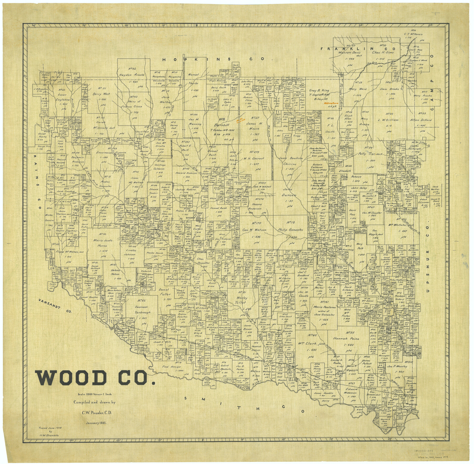
Wood Co.
-
Map/Doc
63136
-
Collection
General Map Collection
-
Object Dates
1895 (Creation Date)
-
People and Organizations
Texas General Land Office (Publisher)
Chas. W. Pressler (Compiler)
Chas. W. Pressler (Draftsman)
-
Counties
Wood
-
Subjects
County
-
Height x Width
35.2 x 36.0 inches
89.4 x 91.4 cm
-
Comments
Traced in June 1914 by H. M. Bramlette.
Part of: General Map Collection
Upton County Sketch File 7

Print $4.00
- Digital $50.00
Upton County Sketch File 7
Size 14.4 x 8.9 inches
Map/Doc 38820
Montgomery Co.

Print $40.00
- Digital $50.00
Montgomery Co.
1943
Size 44.0 x 52.4 inches
Map/Doc 77377
Brewster County Working Sketch 2

Print $20.00
- Digital $50.00
Brewster County Working Sketch 2
1907
Size 29.0 x 26.4 inches
Map/Doc 67535
Outer Continental Shelf Leasing Maps (Louisiana Offshore Operations)

Print $20.00
- Digital $50.00
Outer Continental Shelf Leasing Maps (Louisiana Offshore Operations)
1955
Size 12.4 x 12.7 inches
Map/Doc 76086

Live Oak County Sketch File 27

Print $4.00
- Digital $50.00
Live Oak County Sketch File 27
1922
Size 14.3 x 8.7 inches
Map/Doc 30312
Rusk County Working Sketch 21

Print $20.00
- Digital $50.00
Rusk County Working Sketch 21
1953
Size 27.6 x 28.3 inches
Map/Doc 63657
Williamson County Sketch File 28

Print $20.00
- Digital $50.00
Williamson County Sketch File 28
1941
Size 23.0 x 18.2 inches
Map/Doc 12695
Sterling County Sketch File 26

Print $24.00
- Digital $50.00
Sterling County Sketch File 26
1989
Size 14.2 x 8.8 inches
Map/Doc 37194
Wood County Sketch File 3

Print $4.00
- Digital $50.00
Wood County Sketch File 3
1848
Size 10.1 x 8.1 inches
Map/Doc 40633
Harris County Sketch File B

Print $4.00
- Digital $50.00
Harris County Sketch File B
1860
Size 8.0 x 5.5 inches
Map/Doc 25309
Wharton County

Print $40.00
- Digital $50.00
Wharton County
1946
Size 43.0 x 49.2 inches
Map/Doc 73321
You may also like
Voyages Autour du Monde, et vers les deux poles par terre et par mer - Tome Second

Voyages Autour du Monde, et vers les deux poles par terre et par mer - Tome Second
1782
Map/Doc 97086
[Movements & Objectives of the 143rd & 144th Infantry and many other divisions and regiments, 1918] - Verso
![94139, [Movements & Objectives of the 143rd & 144th Infantry and many other divisions and regiments, 1918] - Verso, Non-GLO Digital Images](https://historictexasmaps.com/wmedia_w700/maps/94139-1.tif.jpg)
Print $40.00
[Movements & Objectives of the 143rd & 144th Infantry and many other divisions and regiments, 1918] - Verso
1918
Size 37.2 x 63.9 inches
Map/Doc 94139
C. C. S. D. & R. G. N. G. RR. Company, Block C2]
![90780, C. C. S. D. & R. G. N. G. RR. Company, Block C2], Twichell Survey Records](https://historictexasmaps.com/wmedia_w700/maps/90780-1.tif.jpg)
Print $20.00
- Digital $50.00
C. C. S. D. & R. G. N. G. RR. Company, Block C2]
Size 14.0 x 21.2 inches
Map/Doc 90780
Reagan County Sketch File 33

Print $4.00
- Digital $50.00
Reagan County Sketch File 33
1948
Size 8.9 x 14.4 inches
Map/Doc 35028
Travis County Working Sketch 60

Print $20.00
- Digital $50.00
Travis County Working Sketch 60
1992
Size 21.8 x 20.9 inches
Map/Doc 69444
Collin County Working Sketch 6

Print $20.00
- Digital $50.00
Collin County Working Sketch 6
1996
Size 11.2 x 42.2 inches
Map/Doc 68100
Flight Mission No. BQR-5K, Frame 64, Brazoria County

Print $20.00
- Digital $50.00
Flight Mission No. BQR-5K, Frame 64, Brazoria County
1952
Size 18.8 x 22.5 inches
Map/Doc 84009
Current Miscellaneous File 64

Print $12.00
- Digital $50.00
Current Miscellaneous File 64
1954
Size 10.8 x 8.5 inches
Map/Doc 74103
Reeves County Sketch File 15

Print $28.00
- Digital $50.00
Reeves County Sketch File 15
1879
Size 13.1 x 8.2 inches
Map/Doc 35194
[Texas & Pacific Railway through Callahan County]
![64234, [Texas & Pacific Railway through Callahan County], General Map Collection](https://historictexasmaps.com/wmedia_w700/maps/64234.tif.jpg)
Print $20.00
- Digital $50.00
[Texas & Pacific Railway through Callahan County]
1918
Size 21.3 x 8.8 inches
Map/Doc 64234
Flight Mission No. DQO-11K, Frame 18, Galveston County

Print $20.00
- Digital $50.00
Flight Mission No. DQO-11K, Frame 18, Galveston County
1952
Size 18.7 x 22.4 inches
Map/Doc 85211
Pecos County Rolled Sketch 81

Print $20.00
- Digital $50.00
Pecos County Rolled Sketch 81
1930
Size 35.9 x 25.4 inches
Map/Doc 7240